Welcome to Hertfordshire Walker

Download and enjoy our FREE walks

Free walks in the Hertfordshire countryside

A bridleway on the first walk in the collection
Hertfordshire Walker has 300 free walks, all complete with maps, directions, photographs, and GPS navigation. No registration or payment required. Simply choose a walk, download it, and you are all set. Hertfordshire Walker will always be free.

Short videos of selected walks

Free videos of some of the free Hertfordshire Walker walks
Fancy checking out our walks before putting your boots on? Well now you can, thanks to keen local walker, Gerry Gross.

Walk 300: Wyddial Loop

5.3 miles (8.5 km) with 58m of total ascent


The route between points 6 & 7
This is a wonderful walk with panoramic views across the Hertfordshire countryside north-east of Buntingford. For large sections of the route you will escape civilisation with the only sound being birdsong. But pick a day when the sun is shining and the sky is clear to get the best from the wide open views along the walk.

Walk 299: Thorley West Loop

4.9 miles (7.9 km) with 43m of total ascent


Looking back along Thorley footpath 13 before point 23
This is an excellent walk for those fascinated by WWII archaeology. You will cross what was once RAF Sawbridgeworth. You will walk along parts of the airfield's perimeter track, pass some aircraft parking bays, as well as a few wartime buildings on the Woodside Trading Estate and Shingle Hall Farm. You will also pass a WWII pillbox.

Walk 298: Bury Green Loop

5.7 miles (9.3 km) with 48m of total ascent


A footpath at point 8 in the walk
This is a great walk for lovers of 'chocolate box' cottages. The picturesque hamlet of Bury Green where the walk starts is full of them. You will then walk across some wonderful rolling countryside with excellent views. You will cross several livestock fields, including one with a broken 'Bull in Field' sign. We didn't see a bull but we did see cattle in the distance. There is an optional detour which we haven't tested. You will also walk around the edge of a polo field where you might spot a polo match taking place.

Walk 297: Patmore Heath South Loop

5.9 miles (9.6 km) with 92m of total ascent


The Harcamlow Way between points 4 & 5
This is our second walk from Patmore Heath, this time venturing south towards Little Hadham. We delayed publishing this route until work on the Little Hadham bypass had been completed. You will cross the new road twice and, along those stretches, will have to put up some traffic noise. But it's worth it for the lovely rolling countryside you will cross along the way. There are some wonderful stretches.

Walk 296: Hitchwood Long Loop

7.2 miles (11.6 km) with 186m of total ascent


The bridleway between points 18 and 19
This is a walk for lovers of wide open spaces. It offers amazing views as it crosses the undulating countryside north-east of Hitchwood. The route follows well-defined rights of way and some quiet country lanes as it weaves its way past Rush Green and St Paul's Walden. The walk passes two pubs along the way.

Walk 295: Ware East Loop

5.7 miles (9.1 km) with 94m of total ascent


The River Ash close to point 28 in the walk
This is a lovely route which crosses the River Ash six times as it weaves its way north-east from Ware. The first part explores open countryside overlooking the beautiful Ash valley before dropping down to follow the course of the river along well-defined public rights of way. It's another route where you will escape the noise of cars and will be able to enjoy birdsong and the sound of running water. The wildflowers are amazing in April.

Walk 294: Weston East Loop

5.3 miles (8.6 km) with 75m of total ascent


A bridleway to the east of Weston
The bridleway between points 10 and 11
This walk covers the rolling countryside to the east of Weston. It's the third in the collection that starts and finishes in the village and the fifth that passes through. This new route explores several new paths as well as some old friends walked in reverse. You will notice birdsong along parts of this route as you leave the noise of civilisation behind.

Walk 293: Hexton Long Loop

7.9 miles (12.7 km) with 153m of total ascent


The Icknield Way soon after point 19 in the walk
This is a lovely walk which criss-crosses the border between Hertfordshire and Bedfordshire four times as we explore parts of the Barton Hills and Pegsdon Hills which were not visited on our two previous routes in the area. The new route combines parts of the two shorter walks but follows different paths, and the previously walked paths are walked in reverse. If you are planning to try this route make sure you pick a dry and clear day, preferably with sunny skies because the views are wonderful.

Walk 292: Panshanger Park Boundary Loop

4 miles (6.3 km) with 87m of total ascent


Looking towards the River Mimram at point 8
This is another walk in the beautiful Panshanger Park. We have several walks in this area. Unlike the others, this walk starts in the car park off Panshanger Lane then follows the boundary of the park making a loop round the ecologically important River Mimram.

Walk 291: Stapleford West Loop

2.8 miles (4.5 km) with 38m of total ascent


Stapleford footpath 4 between points 7 & 8
This short walk south and west of Stapleford includes public rights of way that have not featured in our collection before. The wide open views to the west of the River Beane are excellent. There is also a lovely stretch of the route alongside the River Beane which those who are working through our collection of walks might recognise.

Walk 290: Welwyn Garden City to Wheathampstead Linear

4.8 miles (7.8 km) with 56m of total ascent


The Ayot Greenway between points 8 & 9
Ayot Greenway between points 8 & 9
This linear route follows the course of the former railway line between Welwyn Garden City (WGC) and Wheathampstead. It includes almost the entire length of Ayot Greenway, a former branch line which linked WGC with Luton and Dunstable.

Walk 289: St Albans to Redbourn Linear

5.3 miles (8.5 km) with 20m of total ascent


The River Ver before point 10 in the walk
This linear route follows sections of both The Hertfordshire Way and The River Ver Trail connecting St Albans and Redbourn. The route weaves alongside the River Ver through some lovely countryside. However there are days when walking this route is not possible because a section of The Hertfordshire Way will be closed to the public, details below.

Walk 288: Broxbourne Woods Medium Loop

3.7 miles (6 km) with 92m of total ascent


The route between points 16 & 17
We added this walk in order to take advantage of some new wooden walkways across a particularly boggy stretch of Broxbourne Woods, which is Hertfordshire's only National Nature Reserve (NNR). The section to benefit the most is between points 14 & 17. The addition of this sturdy structure has enabled us to create a new loop to add to several walks in the collection that explore this wonderful woodland.

Walk 287: Nomansland South-East Loop

5.1 miles (8.1 km) with 83m of total ascent


Footpath between points 18 & 19
This walk starts at the car park on Nomansland Common then heads SE along the edge of Heartwood Forest before looping back through Symondshyde Great Wood. It includes several rights-of-way that are new to our Hertfordshire Walker collection of walks as well as revisiting some old favourites.

Walk 286: Willian South Loop

4.2 miles (6.8 km) with 53m of total ascent


The Hertfordshire Way between points 4 & 5
This walk explores an area south of and including Letchworth Greenway following many permissive paths which are not marked on the Ordnance Survey map. It's an area of open countryside with some great views. The paths from point 12 to the end are popular with walkers and joggers.

Walk 285: Preston North Loop

6.6 miles (10.7 km) with 134m of total ascent


Preston bridleway 11 between points 23 & 24
This is a wonderful walk over high rolling countryside with magnificent views. It follows well-defined rights of way including some lovely old tree-lined byways and holloways. The walk starts and finishes at The Red Lion in Preston.

Walk 284: Rabley Heath North Loop

2.5 miles (4 km) with 21m of total ascent
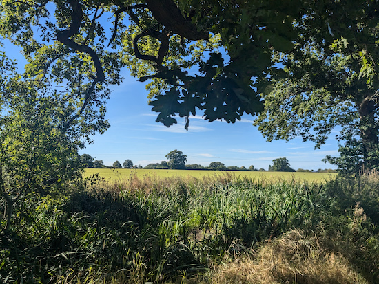

The view from Codicote bridleway 25 at point 7
This is our second walk from Rabley Heath and is one of the shortest in the Hertfordshire Walker collection. It follows well-defined footpaths, bridleways, and quiet country lanes across some lovely countryside. The walk starts and finishes at The Robin Hood & Little John pub at Rabley Heath then passes close to The Lytton Arms which involves a 525m detour at point 6 in the walk.

Walk 283: Much Hadham West Loop

7.4 miles (11.9 km) with 104m of total ascent


The view as you leave Much Hadham
This is a great walk for those who enjoy wide open views across rolling countryside well away from traffic and people. At times all you will hear is birdsong and the occasional plane overhead. There is a good mix of footpaths, bridleways and byways with some shaded stretches.

Facebook group rules

Facebook group rules
We have set 10 rules for our Hertfordshire Walker Facebook group which are designed to help keep the group focused on walking in the Hertfordshire countryside

Promoted charity: The Trussell Trust

Promoted charity: The Trussell Trust
Supporting those locked in poverty