4 miles (6.4km) with 77m of total ascent
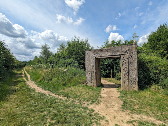 |
| One of the entrances to The Magical Wood at Heartwood Forest |
This is a lovely walk through five wooded areas on the north-west side of
Heartwood Forest and along the edge of a sixth. You will walk through Langley Wood, Round Wood, Pudler's Wood, Well Wood, and The Magical Wood, and along the edge of Pismire Spring.
Despite the title of the walk, only about a third is shaded. The rest follows footpaths through what were meadows and which are now rich in wildflowers.
According to
The Woodland Trust, Heartwood Forest is "
a vast new forest of more than half a million trees, pockets of ancient woodland, wildflower meadows and fantastic wildlife spotting."
The forest covers 347-hectares (858-acres) of what was once mainly agricultural land as well as several old and ancient woodland areas.
The combined site is now the largest continuous new native forest in England. It includes old established woodlands including Pismire Spring and Langley Wood, and newly planted woodland which has matured well over recent years.
The Woodland Trust says the vast majority of the site allows for dogs to be let off the lead, however there are designated areas where dogs must be kept on leads. They are Langley Wood, the areas of ancient woodland, and in the long grass during the bird nesting season.
We have been visiting Heartwood Forest for several years and have four more walks that explore the area, see the
list at the bottom of this page.
Getting there
There are bus stops close to point 2 in the walk (location -
https://w3w.co/guitar.power.risky) and (location -
https://w3w.co/beats.loans.bucket) which are served by the number 304, 305, 357, and 612 buses. You can check bus times at
Intalink.
Fly through preview of walk
If you want to check what sort of landscape you will be crossing before you set off on this walk you can view a short 3D video of the route below. It's created using the free version of
Relive.
Directions
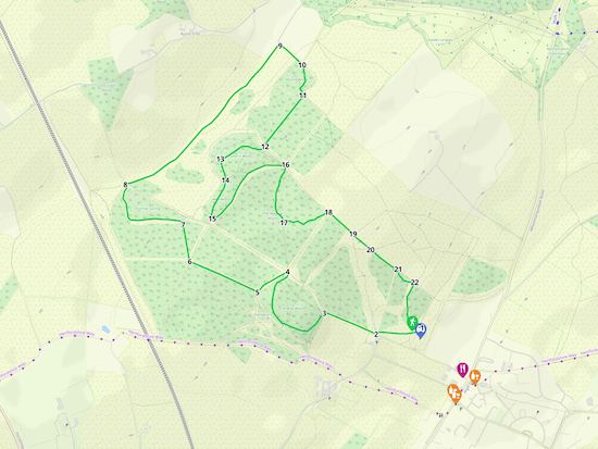 |
Map for 235: Heartwood Forest Six Woods Loop
Click on the map above for a larger version
Created on Map Hub by Hertfordshire Walker
Elements © Thunderforest © OpenStreetMap contributors
There is an interactive map below these directions |
Those with GPS devices can download
GPX or
KML files for this walk. We've added
What3Words location references for those who use that system. If you print these walks you might want to use the green
PrintFriendly icon at the bottom of these directions to delete elements such as photographs.
The walks starts and finishes in the Heartwood Forest car park (location -
https://w3w.co/began.mull.tribal) which, at the time of writing at the end of June 2023, was free-of-charge.
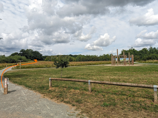 |
| Head diagonally west and uphill from the car park |
1: As you face the information circle (location -
https://w3w.co/swear.chimp.linen) from the car park take the path that heads W and diagonally left and uphill for 200m until you reach a gate (location -
https://w3w.co/deep.lake.actual), see image below.
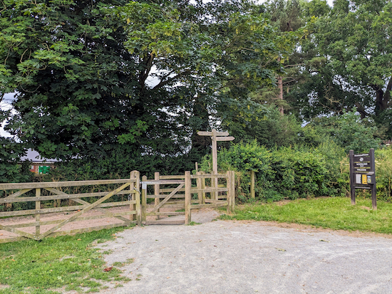 |
| Go through the gate then turn right on Sandridge bridleway 8 |
2: Go through the gate, turn right on Sandridge bridleway 8, then head WNW and uphill for 275m until you reach a path on the left (location -
https://w3w.co/plants.warns.chained), see image below.
 |
| Turn left on a path that heads SSW into Langley Wood |
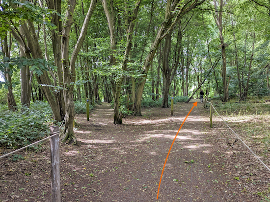
3: Turn left on a path that heads SSW into Langley Wood. If you follow this walk in spring you will be treated to a wonderful display of bluebells on either side of the path. The routes through Langley Wood have been roped off to prevent walkers wandering off the designated paths and damaging the plants. Dog owners are asked to keep their pets on a lead when walking through Langley Wood.
After 80m you will reach a junction (location -
https://w3w.co/camps.lowest.valve), see image below.
 |
| Take the right fork through Langley Wood |
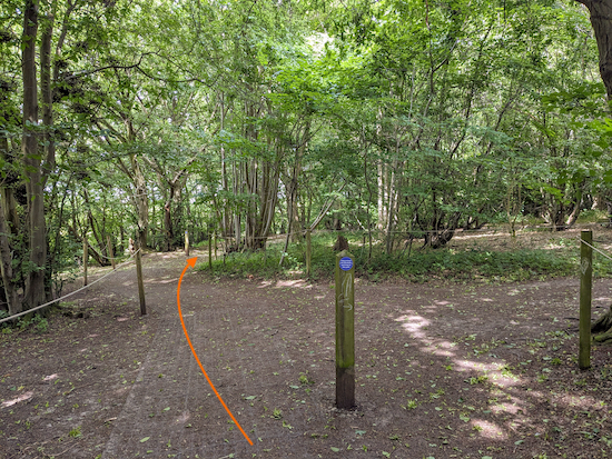
Take the right fork then follow the path WNW for 130m until you reach a junction (location -
https://w3w.co/banana.famed.sides), see image below.
 |
| Ignore paths to the right and left and continue straight |
When you reach the junction ignore the paths to the right and left and continue straight following the path as it bends slightly to the right and heads NW for 30m to another junction (location -
https://w3w.co/deputy.magic.woven), see image below.
 |
| Follow the path as it continues to bend to the right |
Follow the path as it continues to bend to the right then heads N then NNE for 225m until you reach a junction by a bench (location -
https://w3w.co/spring.limit.voters), see image below.
 |
| Turn left before the bench |
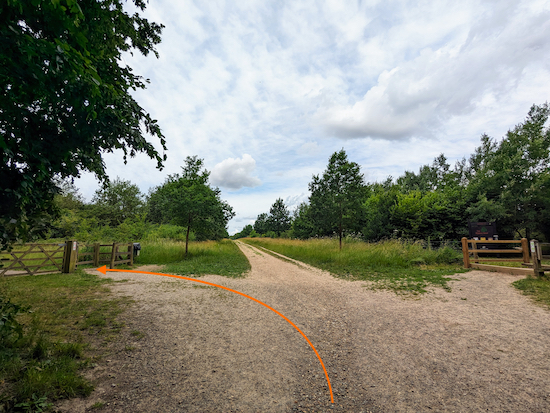
Turn left before the bench then head NNE for 45m until you reach the NW edge of Langley Wood and emerge on Sandridge bridleway 8 (location -
https://w3w.co/smart.burns.dame), see image below.
 |
| Turn left on Sandridge bridleway 8 then turn left through a gate |
4: Turn left on Sandridge bridleway 8 then head NW for 10m before turning left through a gate. Head SW for 155m until you reach a bench on the right (location -
https://w3w.co/fuels.settle.mugs). We spotted a
common spotted-orchid along this stretch.
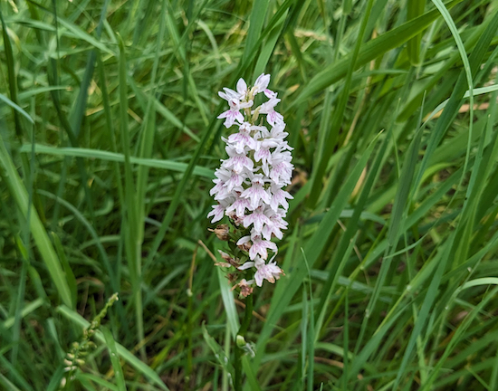 |
| A common spotted-orchid |
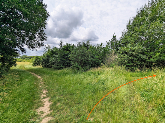
Continue for 15m until you reach a path on the right (location -
https://w3w.co/gained.polite.tiger), see image below.
 |
| Turn right shortly after the bench |
5: Turn right then head WNW. This is a lovely stretch edged by hedgerow.
 |
| Continue heading WNW for 370m |
Continue for 370m until a track crosses the path you are on (location -
https://w3w.co/each.area.rotate), see image below.
 |
| Cross the track then continue on a path through the hedgerow |
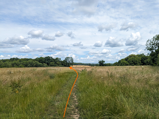
6: Cross the track then continue on a path through the hedgerow. You will pass a bench on the right (location -
https://w3w.co/sings.kick.shirts) then walk across an open field, see image below.
 |
| Head NNW across an open wildflower meadow |
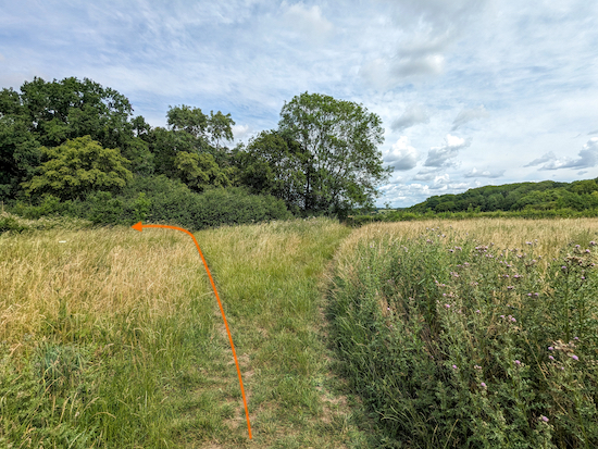
Head NNW across a meadow which was a mass of wildflowers when we tested this route in June. Continue for 180m until the path splits (location -
https://w3w.co/leaned.flats.merit), see image below.
 |
| Take the left fork at the junction |
7: Take the left fork when the path splits then head NW for 20m before reaching a T-junction (location -
https://w3w.co/yards.broom.neck). Turn left at the T-junction on a path that runs along the south side of Pismire Spring, see image below.
 |
| Follow the path along the south side of Pismire Spring |
Pismire Spring was named after a wood ant called the pismire (formica rufa) which spray formic acid as their defence method. At the time of their naming, some noses obviously likened the smell of their acid to that of urine - hence pis-mire! Walkers needn't worry about getting a dose of the spray while in Pismire Spring, as wood ants haven't been known there for perhaps centuries. Thanks to Phil for sharing the information about the ants in
a comment at the foot of these directions.
Spring is the old name given to coppiced woods, usually hazel or hornbeam, which spring back into growth after being cut down.
Follow the path as it heads W for 260m before bending to the right (location -
https://w3w.co/desire.muddy.stuck) then heads N for 170m to a gate (location -
https://w3w.co/thanks.town.wisdom), see image below.
 |
| Go through the gate then head NW to another gate |
Go through the gate then head NW for 15m until you reach another gate (location -
https://w3w.co/ripe.bills.slam), see image below.
 |
| Go through the gate then cross Sandridge bridleway 8 |
8: Go through the gate then cross Sandridge bridleway 8 to another gate, see image below.
 |
| After crossing the bridleway go through another gate |
After crossing the bridleway go through another gate then follow the path NE for 1.1km, with the hedgerow on the left and a wonderful field of wildflowers on the right. Continue until you reach a bend (location -
https://w3w.co/grass.rate.glitz), see image below.
 |
| Turn right at the bend then head SE and uphill |
9: Turn right at the bend then head SE and uphill for 140m. Take a look behind you to your right as you climb this hill for a view of a meadow full of wildflowers.
 |
| The meadow of flowers to the NW of Round Wood |
Continue climbing, with the hedgerow on the left and meadow on the right until you reach woodland. Ignore the first path on the right (location -
https://w3w.co/arch.tanks.bounty) and continue until you reach a path leading into Round Wood on the right (location -
https://w3w.co/bother.cheer.oasis), see image below.
 |
| Turn right into Round Wood |
10: Turn right into Round Wood then follow the path as it zig-zags S for 130m to a junction (location -
https://w3w.co/brass.loses.battle), see image below.
 |
| Turn left at the junction then head SE for 20m |
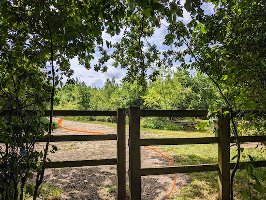
Turn left at the junction then head SE for 20m until you reach a fence leading to a track (location -
https://w3w.co/saints.goes.horn), see image below.
 |
| Cross the track then continue heading straight and SE |
11: Cross the track then continue heading straight and SE for 17m until you reach a path on the right (location -
https://w3w.co/maybe.moving.path), see image below.
 |
| Turn right and head SW |
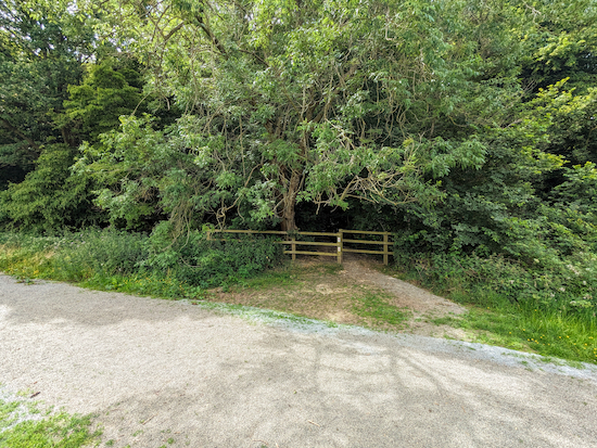
Turn right on this lovely open path and head SW for 325m. You will pass a bench on the left (location -
https://w3w.co/pinks.carry.boot) just before you reach a junction (location -
https://w3w.co/voters.kept.enhancement), see image below.
 |
| Cross the junction then follow the path through Pudler's Wood |
12: Cross the junction then follow the path W then SW through Pudler's Wood for 250m until you reach a junction (location -
https://w3w.co/chops.create.wacky), see image below.
 |
| Turn left at the junction then head S |
13: Turn left at the junction then head S for 110m until you reach a junction (location -
https://w3w.co/remind.fight.work), see image below.
 |
| Cross the junction then continue heading S |
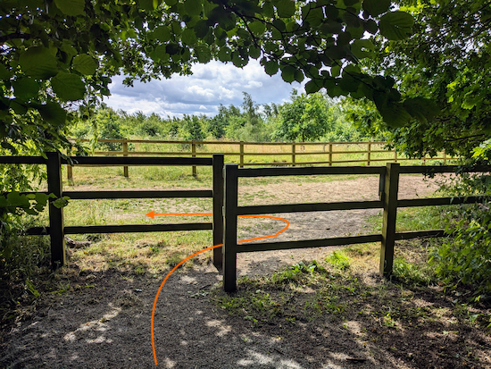
14: Cross the junction then continue heading S, SW, then S. You are now walking through Well Wood which was thought to be the site of an old well which has not been found. What was found was a deep
sink hole which The Woodland Trust filled in for safety reasons. Continue along the path through Well Wood for 210m to a fence leading to a junction (location -
https://w3w.co/forms.songs.aspect), see image below.
 |
| Turn left after leaving Well Wood |
15: After passing through the gap in the fence turn left then follow the path NE for 480m to a junction (location -
https://w3w.co/stands.slower.spine), see image below.
 |
| Turn right then right again to enter The Magical Wood |
16: When you reach the junction turn right then right again to enter The Magical Wood. Head S for 300m to a junction in the centre of the wood where you will find picnic tables and a tunnel for the little ones to explore (location -
https://w3w.co/ticket.strain.backed), see images below.
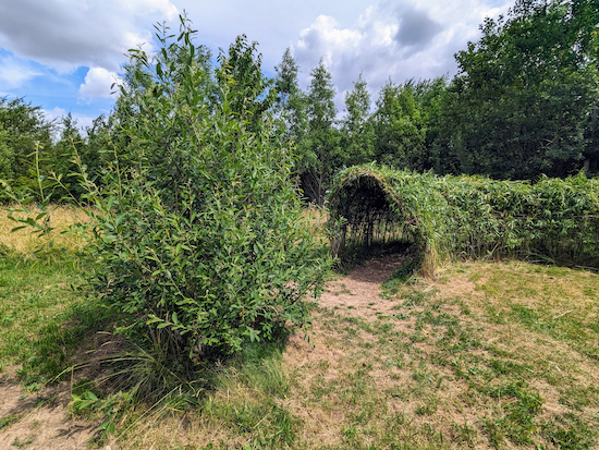 |
| The tunnel in the centre of The Magical Wood |
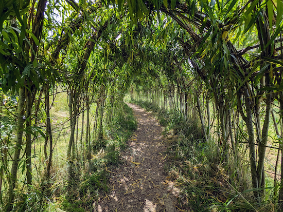 |
| Inside The Magical Wood tunnel |
 |
| After the tunnel turn left then follow the path E |
17: After the tunnel, turn left then follow the path E for 230m. Along the way see if you can spot the worried owl on the right of the path (location -
https://w3w.co/fees.pinks.photos), see image below.
 |
| The worried owl alongside the path in The Magical Wood |
Continue on this path until you leave The Magical Wood at a wooden arch and reach a junction (location -
https://w3w.co/park.issues.vote), see image below.
 |
| Go through the arch then take the second path on the right |
18: Go through the arch, ignore the first path immediately on your right, and continue to the second path on the right (see orange arrow on the image above).
Head SE along this path for 160m to a junction (location -
https://w3w.co/putty.kick.moth), see image below.
 |
| Continue heading SE keeping to the right of the hedgerow |
19: Continue heading SE keeping to the right of the hedgerow with the meadow on the right and the hedgerow on the left (see orange arrow on the photograph above) for 120m to another junction (location -
https://w3w.co/fault.foster.meal), see image below.
 |
| Cross the junction then continue heading SE |
20: Cross the junction then continue heading SE with the hedgerow on the left and meadow on the right for 170m until you reach a junction (location -
https://w3w.co/notice.smiled.today), see image below.
 |
| Turn right on the detour |
21: At this point the path used to continue heading SE, but The Woodland Trust has created a detour in order to protect the habitat in the area. Turn right to take the detour then head S, SE, then E for 120m until you reach a gravelled track (location -
https://w3w.co/exist.fence.bronze), see image below.
 |
| Turn right on the gravelled track then head S back to the car park |
22: Turn right on the gravelled track then head S for 270m to the car park and the starting point.
The Woodland Trust has
a map on its Heartwood Forest website showing all the paths. There is also a pdf, which we have embedded below. They ask walkers to stay on the designated paths.
There are three pubs in Sandridge. The pubs are
The Green Man (location -
https://w3w.co/units.jolly.rail),
The Rose and Crown (location -
https://w3w.co/truth.bronze.agenda), and
The Queens Head (location -
https://w3w.co/alarm.solo.decay). There is also
Heartwood Tearooms attached to the village store.
Our other walks in Heartwood Forest
This walk is our fifth route in and around Heartwood Forest. The others are:
Interactive map


We completed this very enjoyable walk on 20 July. It contains a good mix of woodland and open fields. We got into a bit of a muddle in Langley and Pudler's Woods, but soon found our way. The marker post shown in the second photo under 3 had fallen over and been placed away from the path.
ReplyDeleteIt would be helpful to have the postcode for the starting point to use in sat navs, although for this walk the postcode for the car park led us to Langley Grove, on the wrong side of Sandridge High Street.
Glad you enjoyed it. Sorry to hear the marker post had fallen down. We use What3Words for reference points instead of postcodes because they are more accurate. Postcodes cover a much wider area. The What3Words reference for the car park is in the directions and is (https://what3words.com/began.mull.tribal). Just enter your destination's what3words address into the what3words app, then tap 'Navigate' to get directions in your favourite apps such as Google Maps, Waze or Navmii.
DeleteNice walk and description! Just a minor comment on the wood ants which gave Pismire Spring its name. The ants in question (Formica rufa, as currently known) don't actually spray urine, but Formic Acid, as their defence method. At the time of their naming, some noses obviously likened the smell of their acid to that of urine - hence pis-mire! Walkers needn't worry about getting a dose of the spray while in Pismire Spring, as wood ants haven't been known there for perhaps centuries!
ReplyDeleteThanks Phil, very interesting. I have added that information to the walk directions (below point 7) and credited you as the source. By the way, if you haven't already done so, please consider joining our members-only Facebook group where people are sharing information, tips and photos about the walks they are enjoying in the Hertfordshire countryside. David
Deletehttps://www.facebook.com/groups/hertfordshirewalker
We’ve done this walk a couple of times now. It is great that it takes you away from the main areas of the woods which can get busy. Our dog has loved having new areas to explore. Thanks for setting up this website and taking the time to map all the walks - it really is a fantastic resource. Having the w3words links to follow is so helpful for knowing you are heading in the right direction. We hope to try a new long walk each week when the weather allows.
ReplyDeleteHi Carolyn, it's really nice to hear that you and you dog like that walk. We added that walk because we enjoyed the fact that you can escape the crowds (when the rest of Heartwood Forest gets busy). Thanks for the feedback. There is someone with the same name in our Facebook group. If it's you, please feel free to share any photos taken along our routes. David
ReplyDeletehttps://www.facebook.com/groups/hertfordshirewalker
Just tried this walk. People seemed to be losing
ReplyDeletethe instructions around point 8 where you needed to fork right up a hill with hedge on left and meadow on right before turning right through a wood. Never found the correct right bend. Tried two or three then just asked other people who were also confused and headed down hill to carpark. Shame entrances to woods don't say which they are. Will try again when maybe vegetation will help . Looking forward to seeing bluebells in the Spring.
Sorry you got confused. Previous comments haven't reported the same problem. At point 8 you DO NOT fork right up a hill. That is the wrong way. There is a fork there, but the directions clearly state "Go through the gate then cross Sandridge bridleway 8 to another gate. After crossing the bridleway go through another gate then follow the path NE for 1.1km, with the hedgerow on the left and a wonderful field of wildflowers on the right. Continue until you reach a bend". It seems that, if took the fork going uphill you did not head NE with the hedgerow on the left as stipulated in the walk directions. Next time you might want to try following the free GPX file that comes with the directions. That way you can use your phone like a sat nav to help you.
Delete