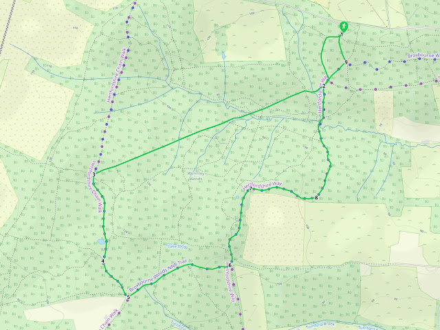
2.5 miles (4 km) with 76m total ascent
 |
Fly through preview of walk
If you want to check what sort of landscape you will be crossing before you set off on this walk you can view a short 3D video of the route below. It's created using the free version of Relive.
Directions
GPX or KML files for this walk. We've added What3Words location references for those who use that system. If you print these walks you might want to use the green PrintFriendly icon at the bottom of these directions to delete elements such as photographs.
Park in Bencroft Wood (West) car park on the south side of White Stubbs Lane (location - https://w3w.co/candy.expose.couches). It's a free car park but has limited space. You will find a sign in the car park with a map showing two trail options for Bencroft Wood, but your route is not one of them, although the first section uses one of the paths on our route in order to access Wormley Wood.
1: From the car park head SW, following the wooden signs with the purple circle around the top. Continue as the path heads S downhill, first down some wooden steps and then along a wooden elevated walkway.
 |
| Follow the trail downhill and S |
 |
| Cross the footbridge and climb the steps as you continue to head SW |
 |
| Continue heading WSW as the track climbs through the woodland |
This is the only exposed part of the walk and you will spend about five minutes walking along an elevated walkway with flowers either side. Look out for butterflies along this part of the path. It's a charming section.
 |
| A Silver-Washed Fritillary butterfly on brambles between points 3 & 4 |
 |
| After the elevated walkway section you enter the woods again |
6: At the next footpath crossing turn left and head N and NE for 360m.
7: When you reach the coal post on your left (location - https://w3w.co/words.fact.struck), turn right and head E for 300m.
 |
| The coal post at point 7 on the route |
9: At the point where a track crosses your path, turn left and head NNW for 110m back to the car park, see image below.
 |
| Turn left and head N back to the car park |


Worth noting that the Bencroft Wood (West) carpark on the south side of White Stubbs Lane (WSL) is currently closed. An abandoned caravan is stuck in the height-restricted entrance. The local council is aware of the issue, according to stickers. on the caravan. But you can still park in the Bencroft Wood (East) carpark which is also on the south side of WSL just before the junction with West End Lane. There is a well-defined path between the 2 carparks which runs parallel to WSL about 50m in from the road. If you park in the east carpark and follow this path at the beginning and end of your walk, it extends the walk to about 3.5miles, but you will still be in the woods for the whole circuit.
ReplyDeleteThanks for that. Good to know. Dave
DeleteHi David Update from previous message . Caravan has gone all clear . Walked this route again today but in reverse . Still a lovely walk on a crisp day like today . Thank You. .IR.
ReplyDeleteHi Ian, we often do walks in reverse. So different. Thanks for the update.
DeleteA lovely walk in dappled shade - great on a hot, sunny day.
ReplyDeleteWe walked it in June and there were still a few areas of mud but perfectly manageable in walking shoes. I would imagine it could be difficult in places in wintertime.
Great to see our first “coal post”. I need to find out more about them …
There is a link in the walk directions to an article I wrote about coal posts. It's at point 7. Click on the words coal post in green in the directions.
Delete