4.9 miles (7.9 km) with 98m of total ascent
 |
| Hatfield footpath 59 crossing the River Lea at point 20 |
This is a lovely walk over rolling countryside. You will cross the River Lea four times, pass a Grade II listed chimney that is said to have been part of a house where John Bunyan lived, and you will cross a golf course with excellent views of the Brocket Hall estate from a Grade II* listed bridge.
The walk starts in the village of
Lemsford then heads west to Coleman Green before looping back via Cromer Hyde. There are alternative starting points at pubs at point 10 and point 18 in the directions.
We had wanted to explore this loop for some time and were able to add it to the collection after finding a track that links two public rights of way and avoids having to walk alongside a busy road. However you will have to cross the B653 Hatfield to Wheathampstead Road twice, so please take care if you are walking with small children or in a large group.
This walk includes some of the same rights of way as
Walk 193: Lemsford West Loop, but those that are repeated are walked in reverse, and this new route branches out further to the west to reach Coleman Green.
Getting there
There are bus stops in Lemsford close to the start of the walk (location -
https://w3w.co/ages.staple.glory). They are served by the number 366 bus. There are also stops at point 18 close to The Crooked Chimney (location -
https://w3w.co/feels.cheat.fuzzy), served by the number 366 and 601 buses. You can check bus times at Intalink.
Parking
Parking is difficult in Lemsford, but the management at
The Sun pub/restaurant at the start/finish point told me that walkers are welcome to park in the pub's car park if they are buying refreshments before or after the walk. Please check with The Sun by calling
01707-322247.
You can also park at
The John Bunyan pub/restaurant at point 10 in the walk and start the route from there. Management there told me that walkers are welcome to park in their car park if they are buying refreshments before or after the walk. Please check with The John Bunyan by calling
01582-832037. The John Bunyan asks walking groups who intend to eat at the pub to let them know in advance so they can meet your catering requirements.
The Crooked Chimney pub/restaurant at point 18 in the walk told me that it also allows walkers to use their car park if they are buying refreshments before or after the walk. Please check with the pub on
01707-397021 to make sure this has not changed.
Fly through preview of walk
If you want to check what sort of landscape you will be crossing before you set off on this walk you can view a short 3D video of the route below. It's created using the free version of
Relive.
Directions
 |
Map for Walk 246: Lemsford West Long Loop
Click on the map above for a larger version
Created on Map Hub by Hertfordshire Walker
Elements © Thunderforest © OpenStreetMap contributors
There is an interactive map below these directions |
Those with GPS devices can download
GPX or
KML files for this walk. We've added
What3Words location references for those who use that system. If you print these walks you might want to use the green
PrintFriendly icon at the bottom of these directions to delete elements such as photographs.
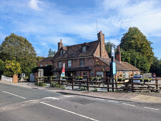 |
| As you face The Sun turn right then head SW |
1: As you face The Sun pub/restaurant (location -
https://w3w.co/retire.daisy.shell), with your back to the
River Lea, turn right then head SW for 65m until you reach a road leading to a bridge and a footbridge on the right (location -
https://w3w.co/reform.rang.bands), see image below.
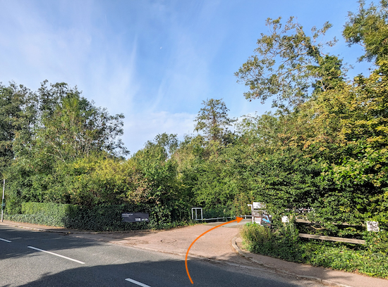 |
| Turn right, then cross a footbridge over the River Lea |
Turn right, then head NW for 75m crossing a footbridge over the River Lea and continuing to a
footpath junction (location -
https://w3w.co/backed.cycle.funded), see image below.
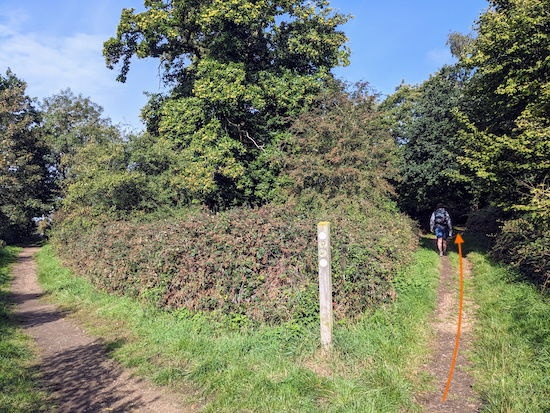 |
| Take the right fork at the footpath junction |
2: Take the right fork at the footpath junction then follow Hatfield footpath 57 NW across the Brocket Hall golf course for 550m. You will cross several fairways so take care to look both ways. Continue until you reach a footpath junction (location -
https://w3w.co/scarcely.rocky.film), see image below.
 |
| Keep heading NW, and still on Hatfield footpath 57 |
3: Keep heading NW, and still on Hatfield footpath 57, with fir trees on the left and the golf course on the right. Continue for 280m until you reach a metalled track (location -
https://w3w.co/sleepy.shades.crate), see image below.
 |
| Cross the metalled track then continue heading NW |
4: Cross the metalled track then continue heading NW, still on Hatfield footpath 57, (see the orange arrow on the photograph above).
Follow Hatfield footpath 57 as it heads NW for 520m until you leave the golf course and enter woodland (location -
https://w3w.co/lace.throw.case), see image below.
 |
| Enter the woodland, still on Hatfield footpath 57 |
5: Enter the woodland and continue heading NW, still on Hatfield footpath 57, for 245m until the footpath drops down to a junction (location -
https://w3w.co/cases.enable.whips), see image below. Just before this junction the footpath you are on crosses a parish boundary and becomes Wheathampstead footpath 13.
 |
| Turn left at the junction on Wheathampstead footpath 15 |
6: Turn left at the junction then head SW on Wheathampstead footpath 15. After 70m you will cross the River Lea and will pass an interesting flint and brick structure on the right, see image below.
 |
| Continue as the footpath climbs a hill |
Continue, as the footpath climbs a hill and crosses another parish boundary (location -
https://w3w.co/shark.being.cloth) where it becomes Hatfield footpath 97. Follow this footpath for 395m until you reach a disused lay-by off the B653 (location -
https://w3w.co/races.clues.glitz). Turn right in the lay-by then head NW until you reach a path on the right just before the road (location -
https://w3w.co/assure.vital.pipes), see image below.
 |
| Follow this path NW for 60m until you reach a fork |
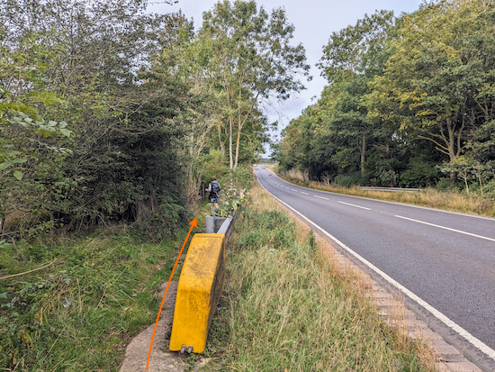
7: Follow this path NW for 60m until you reach a fork with a path leading off to the left leading to the B653. Take this left-hand fork to reach the road just to the left of a yellow crash barrier (location -
https://w3w.co/twist.avoid.lawn), see image below.
 |
| Cross the B653 with care - traffic travels at speed along this stretch |
8: Cross the road with care. Traffic travels at speed along this stretch. Once across the road turn right then follow the path behind the crash barrier (location -
https://w3w.co/kicked.skips.became), see image below.
 |
| Continue following the path downhill to a junction |
Continue following the path downhill to a junction. I have created a closeup of the route map showing this section of the walk, see below.
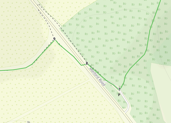 |
| The route between points 7 & 9 |
9: When you reach the junction (location -
https://w3w.co/drop.crops.exit) turn left, see image below.
 |
| At the junction turn left on a byway |
You will now head SW on a BOAT (
byway open to all traffic). This is an interesting byway because it follows a parish boundary for its entire 1.5km length and therefore has two names; it is both Wheathampstead BOAT 3 and Hatfield BOAT 56. It is also an enchanting
holloway where you can just sense the history of bygone ages and you walk between the twisted trees. It's easy to imagine bumping into a character from a Hardy or Dickens novel along this stretch.
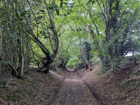 |
| The byway that is both Wheathampstead BOAT 3 and Hatfield BOAT 56 |
When you reach the end of the BOAT look to your right and you will see the
Grade II listed site that is John Bunyan's Chimney (location -
https://w3w.co/filled.tigers.album). It's worth stopping here for a while to take a look.
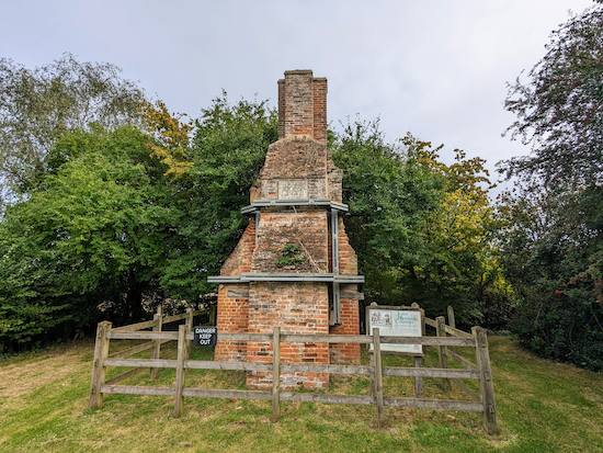 |
| John Bunyan's Chimney from the front |
 |
John Bunyan's Chimney from the side
|
 |
The information board at John Bunyan's Chimney
Click on the image for a larger version |
10: After visiting the monument turn left on Coleman Green Lane then head SW passing The John Bunyan pub on the right (location -
https://w3w.co/shut.slide.bucks), see image below.
 |
| The John Bunyan pub |
Continuing heading SW along Coleman Green Lane for 160m until you reach a footpath on the left (location -
https://w3w.co/feels.divisions.line), see image below.
 |
| Turn left on Sandridge footpath 39 |
11: Turn left on Sandridge footpath 39 then follow it SE for 35m to a junction (location -
https://w3w.co/latest.each.being) where you continue to head SE, now on Hatfield footpath 48, with the hedgerow on the right and field on the left, see image below.
 |
| Continue heading SE on Hatfield footpath 48 |
Continue heading SE on Hatfield footpath 48 until you reach a gap in the hedgerow at the corner of a field (location -
https://w3w.co/glory.slang.trips), see image below.
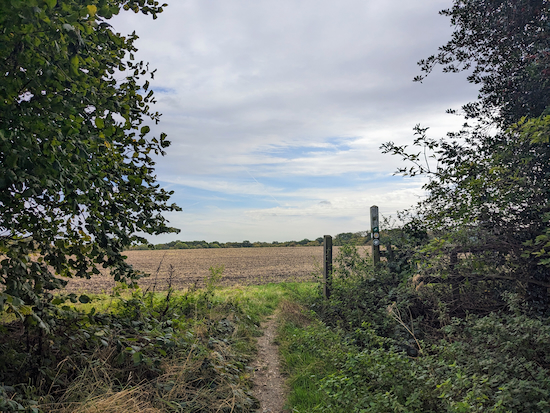 |
| Go through the gap then head SSE still on Hatfield footpath 48 |
12: Go through the gap then head SSE, still on Hatfield footpath 48, for 80m until the path crosses an arable field (location -
https://w3w.co/festivity.basket.study), see image below.
 |
| Cross the arable field, still on Hatfield footpath 48 |
When we tested this walk on 6 October 2023 the path had not been reinstated after being cultivated, but walkers had trodden a route across the field.
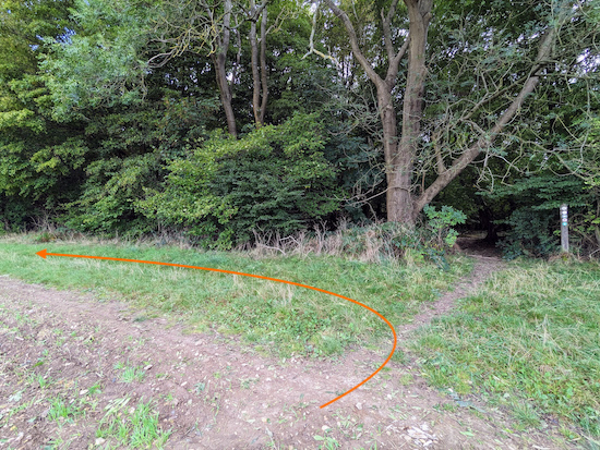
13: Cross the arable field, still on Hatfield footpath 48, heading SSE for 330m until you reach woodland and a junction (location -
https://w3w.co/fields.reward.prefer), see image below.
 |
| Don't enter the woodland but turn left and walk NE along the edge |
14: Don't enter the woodland but turn left and walk NNE along the edge on Hatfield footpath 52 for 160m until the path crosses a field (location -
https://w3w.co/pardon.party.cycle), see image below.
 |
| Cross the field, still on Hatfield footpath 52 |
15: Cross the field, still on Hatfield footpath 52 and now heading NE, for 295m until you reach a gap in the woodland (location -
https://w3w.co/eating.worth.leave).
 |
| Go through the gap then continue across an arable field |
16: Go through the gap then continue across an arable field, still on Hatfield footpath 52 and still heading NE, for 355m until you reach Cromer Hyde Lane (location -
https://w3w.co/stores.mimic.scrap). This field had not been reinstated following recent cultivation (03/10/2023) but walkers had trodden a route. See the orange arrow on the photograph above.
 |
| Turn right on Cromer Hyde Lane |
17: Turn right on Cromer Hyde Lane then follow it in an easterly direction for 855m until you reach the B653 (location -
https://w3w.co/scale.herb.chips). It was along this stretch that we met a young deer and gently ushered it into the undergrowth.
 |
| Young deer on Cromer Hyde Lane |
18: When you reach the B653 you could turn right for refreshments at
The Crooked Chimney pub/restaurant (location -
https://w3w.co/leader.frost.bend). If not, cross the road then take the footpath on the other side (location -
https://w3w.co/reject.stand.moons), see image below.
 |
| Follow Hatfield footpath 59 ENE until you reach an ornate bridge |
Follow Hatfield footpath 59 ENE for 505m until you reach an ornate bridge over the River Lea (location -
https://w3w.co/amused.pouch.liability), see image below. This is
Paine Bridge, a Grade II* listed structure.
 |
| Brocket Hall viewed from the bridge over the River Lea |
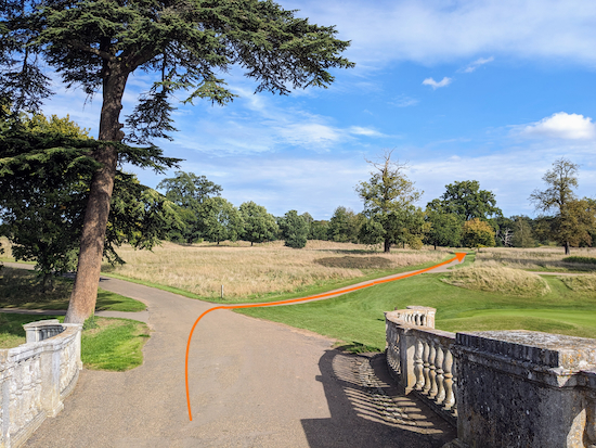
19: Cross the bridge then head ENE for 25m until you reach a fork (location -
https://w3w.co/level.index.fool), see image below.
 |
| Take the right fork, Hatfield footpath 65 |
Take the right fork, which is Hatfield footpath 65, then head SE for 70m, ignoring a golf track on the right, before keeping right at a fork (location -
https://w3w.co/deep.chest.loops) still on Hatfield footpath 65, see image below.
 |
| Take the right fork and follow Hatfield footpath 65 |
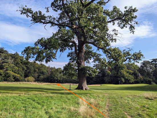
Continue along Hatfield footpath 65, and still heading SE, for 330m until you reach a large tree (location -
https://w3w.co/reject.shunts.across) and a golf green on the right, see image below.
 |
| Keep left of the tree then continue heading SE on Hatfield footpath 65 |
Keep left of the tree then continue heading SE, still on Hatfield footpath 65, for 135m until you reach the junction you passed at point 2 in the walk (location -
https://w3w.co/move.book.sung). From there retrace your steps over the River Lea and back to Lemsford.
Interactive map


This is a lovely walk through woods countryside and golf course. Not to strenuous and the dogs loved it
ReplyDeleteWonderful, glad you enjoyed it. Perhaps it was you that just shared some lovely photos on our Facebook group. If not, please consider joining the group where fellow walkers are sharing their walking experiences and photos. David
Deletehttps://www.facebook.com/groups/hertfordshirewalker
Did walk 246 today. Great walk but the byway BOAT 3 is more like a river at moment! We'll attempt it again and see if there's access along edge of field to left of byway
ReplyDeleteWhat a pity. That is usually a lovely byway, but I can imagine that it could become a river after rain. Glad it didn't put you off trying it again.
DeleteWe walked this today. The arable field at point 16 has been ploughed and there is no visible path again. We walked across but it was difficult. The walk is otherwise lovely and easy to follow. We have walked quite a few of the walks on this site and we are so grateful to the Brewers for what they have provided for everyone’s benefit. They deserve an honour.
ReplyDeleteWalked this today. Great walk except the arable field mentioned at point 16 has been ploughed and any path across it has been obliterated. We did cross the large field but it was difficult. Also we are so grateful to the Brewers for all the work they have done. The site is brilliant and they deserve an Honour.
ReplyDeleteYes, public rights of way being ploughed over is fairly common this time of the years once the harvest has been gathered. Landowners have to reinstate the paths within 14 days, but in my experience this deadline often gets missed. I then report the issue to the Hertfordshire County Council Rights of Way team and they deal with it. The law states that farmers should "avoid cultivating a cross-field footpath or bridleway", but, if they have to cultivate they must make sure the footpath or bridleway "remains apparent on the ground to at least the minimum width of 1 metre for a footpath or 2 metres for a bridleway, and is not obstructed by crops". But glad you enjoyed the walk despite this. And thanks for your kind words.
Deletehttps://www.hertfordshirewalker.uk/p/tips.html#faults
Walked this on 2 Mar 2025. The holloway (never heard this word before!) was pretty muddy with a few tricky spots where it was better to walk on the sloping sides, but all perfectly doable. The directions on this site are outstanding – could not be clearer and the use of W3W at every point removed all ambiguity. Thank you for this!
ReplyDeleteThanks for the feedback. Glad you enjoyed the walk and found the directions helpful.
DeleteDid this walk this morning with a friend. Lovely scenery and autumn colours, very few other walkers, and no mud yet. It was useful to have 3 pubs on the route for loo stops. John Bunyan's Chimney was interesting! A good mix of woodland and open fields, and the GPX route was very clear and easy to follow.
ReplyDelete