4.2 miles (6.6 km) with 118m total ascent
 |
| Hornbeam Lane between points 8 & 9 |
This is a lovely circular walk along footpaths, bridleways, quiet lanes, and through shaded woodland. Some of the paths can be muddy at certain times of the year, and there are nettles to deal with on some of the narrow paths in the summer months. The walk starts and finishes at The Woodman, Wildhill.
Please note that this route involves walking along a section of Cucumber Lane where there is no pedestrian pavement. The lane has always been quiet on the dozens of times we have walked it, but a user of Hertfordshire Walker reported (October 2024) that it was busy when they walked the route. Walking groups or those walking with children might want to choose a different walk from our collection.
Getting there
There is a bus stop outside The Woodman at the start of the walk which is served by the numbers 200 and 201 buses. You can check bus times at
Intalink.
Fly through preview of walk
If you want to check what sort of landscape you will be crossing before you set off on this walk you can view a short 3D video of the route below. It's created using the free version of
Relive.
Directions
 |
Map for Walk 17: Hornbeam Lane Loop
Click on the map above for a larger version
Created on Map Hub by Hertfordshire Walker
Elements © Thunderforest © OpenStreetMap contributors
There is an interactive map embedded at the end of these directions |
Those with GPS devices can download
GPX or
KML files for this walk. We've added
What3Words references for those who use that system. If you print these walks you might want to use the green
PrintFriendly icon at the bottom of these directions to delete elements such as photographs.
If you intend to take refreshments before or after your walk the landlord at The Woodman says you are welcome to use the pub car park (location -
https://w3w.co/congratulations.trim.usual).
1: As you enter The Woodman car park head S with the beer garden on your left and the pub on your right then take the footpath just below the beer garden on the E side of the car park (location -
https://w3w.co/star.yard.oppose), see orange arrow on the image below.
 |
| The footpath is just below the beer garden, see orange arrow |
 |
| Go through a metal gate then follow Hatfield footpath 85 |
Go through a metal gate then follow Hatfield footpath 85 uphill and diagonally SE across a field for 130m until you reach a gate in the hedgerow (location -
https://w3w.co/trials.shins.ever).
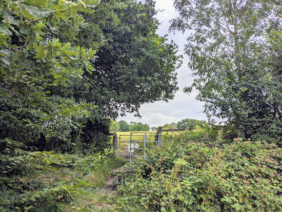
2: Go through the gate then head SSE across a field for 135m, still on Hatfield footpath 85, until you reach another gate at the edge of woodland (location -
https://w3w.co/pizza.began.sands), see image below.
 |
| Continue through the gate with the woodland on your left |
3: Continue through the gate then head SE, still on Hatfield footpath 85, with the woodland on your left for 145m until the path crosses the corner of a field for 125m then it goes through a gap in the hedgerow to reach the B158, (location -
https://w3w.co/tight.meal.puddles), see image below.
 |
| Hatfield footpath 85 cuts through the hedgerow |
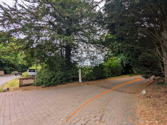
4: Cross the road then turn left and walk NE along the E side of the B158 for 315m until you reach a footpath on the right at the point where Wildhill Road goes off to the left (location -
https://w3w.co/filed.author.dame), see image below.
 |
| Turn right along Essendon footpath 19 |
5: Turn right along Essendon footpath 19, which follows a private road heading SE for 140m before the footpath veers to the left (location -
https://w3w.co/ripe.tunes.pies), see image below.
 |
| Keep left and continue heading SE on Essendon footpath 19 |
Continue heading SE on Essendon footpath 19 for 70m until you reach a wooden footbridge and a gate on the left (location -
https://w3w.co/gender.splice.funny), see image below.
 |
| Go through the gate then head NE on Essendon footpath 20 |
6: Turn left then go through the gate and keep to the right heading NE. Follow Essendon footpath 20 with the woodland on your right and the field on your left. After 120m you will reach the end of the woodland where you drop down slightly to the right to go through a wooden gate by an outbuilding (location -
https://w3w.co/fields.blast.funded), see image below.
 |
| Go through the gate then continue on Essendon footpath 20 |
Turn right, go through the gate, then continue heading NE, now with the house and gardens on your right and the hedge on your left for 70m until you reach Hornbeam Lane.
7: Turn right on Hornbeam Lane, which is also Essendon bridleway 18, then head SW for 260m until Hornbeam Lane becomes a track (location -
https://w3w.co/globe.snaps.drape), see image below.
 |
| Continue along Essendon bridleway 18 |
8: Continue along Essendon bridleway 18 for 985m until you reach Cucumber Lane (location -
https://w3w.co/seated.seats.older), see image below.
 |
| Turn left on Cucumber Lane |
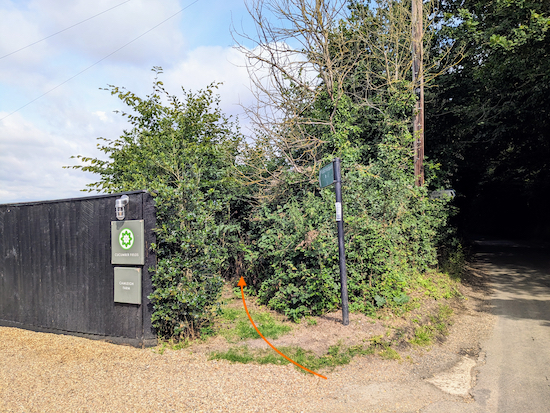
9: Turn left on Cucumber Lane then head NNW for 1.3km until you reach Berkhamsted Lane on the right and a footpath on the left (location -
https://w3w.co/gave.spot.mess), see image below.
 |
| Turn left on Essendon footpath 6 |
10: Turn left on Essendon footpath 6 then head NNW for 120m before the path bends left (location -
https://w3w.co/island.fake.love).
11: Continue following Essendon footpath 6 as it heads W for 210m, with the hedgerow on the right and livestock fields on the left, until you reach the B158 (location -
https://w3w.co/yards.pushy.trunk), see image below.
 |
| Cross the road and continue on Essendon footpath 16 |
12: Cross the road then take the footpath opposite, which is still Essendon footpath 16. Follow the footpath down a set of wooden steps into Panther’s Wood and a footbridge (location -
https://w3w.co/actor.slide.parent), see image below.
 |
| Cross the footbridge over Essendon Brook |
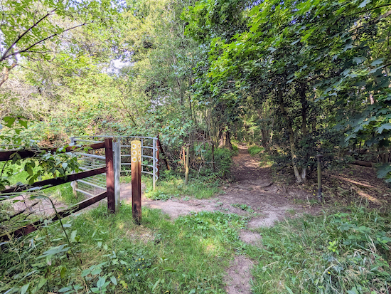
Cross the footbridge over Essendon Brook then turn right and head NW for 30m to a junction (location -
https://w3w.co/fuzzy.metals.gravy), see image below.
 |
| Keep heading straight at the junction, still on Essendon footpath 16 |
13: Keep heading straight and NW at the junction, still on Essendon footpath 16, continuing for 425m until you reach a footbridge (location -
https://w3w.co/globe.school.sprint), see image below.
 |
| Cross the footbridge still on Essendon footpath 16 |
14: Cross a footbridge then climb the hill with the field on your left and the hedgerow on your right until you come to a gate (location -
https://w3w.co/gosh.calculating.wiser) leading to Essendon BOAT 14 (
byway open to all traffic).
 |
| Turn left then head SE along Essendon BOAT 14 |
15: Turn left then head SE along Essendon BOAT 14 for 640m to West End Lane (location -
https://w3w.co/aspect.tones.blank), see image below.
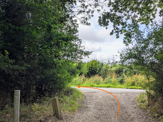 |
| Turn left on West End Lane |
16: Turn left on West End Lane then follow the lane S for 110m then SW for 115m until you reach a left-hand bend with a track on your right (location -
https://w3w.co/passes.tribe.froth), see image below.
 |
| Keep left at the bend then head downhill |
17: Keep left at the bend then head SSE and downhill for 485m to Wildhill Road (location -
https://w3w.co/fuel.full.rental).
18: Turn left on Wildhill Road then head E for 115m back to The Woodman and the start of the walk.
 |
| The Woodman at Wildhill |
We have dedicated this walk to the late
Nigel Hickson (1956 - 2025), a local man whose family members walked the route on Saturday 4 October in his memory because it was
"an area he loved to walk".
Interactive Map


Enjoyable and easy to follow route, good for dogs but limited 'off lead' stretches (particularly if you have a pooch that roams!)
ReplyDeleteNice walk and good directions, thanks! The stretches in Hornbeam Wood & Panthers Wood were particularly enjoyable. Nice to see donkeys, goats and alpacas grazing in the fields just off Cucumber Lane.
ReplyDeleteHi Gareth, glad you enjoyed it. That is one of our local walks which we often enjoy revisiting, especially when it ends with a pint at The Woodman. David
DeleteLovely walk with very easy to follow directions. We really enjoyed it today despite the weather but our waterproof walking boots were tested to the limit
ReplyDeleteGlad you enjoyed the walk, despite the mud. If you are not already a member please consider joining out Hertfordshire Walker Facebook group where fellow walkers are sharing photos and reports from their walks.
Deletehttps://www.facebook.com/groups/hertfordshirewalker