5.5 miles (8.8 km) with 104m of total ascent
 |
| A footpath along the route Photograph courtesy of Chris Dowsett |
Some sections of this walk can be muddy when wet, particularly between points 2 and 5 and 21 to the end. There are a couple of sections which can become overgrown with nettles in the summer.
Getting there
There are bus stops close to The Bull in Cottered at the start of the walk served by the number 37 bus. You can check bus times at Intalink.
Fly through preview of walk
If you want to check what sort of landscape you will be crossing before you set off on this walk you can view a short 3D video of the route below. It's created using the free version of Relive.
Directions
 |
| Map for Walk 166: Cottered North Loop Click on the map for a larger version Created on Map Hub by Hertfordshire Walker Elements © Thunderforest © OpenStreetMap contributors There is an interactive map below these directions |
1: With your back to The Bull in Cottered (location - https://w3w.co/surpasses.extend.responses), turn right then head W along Baldock Road for 370m until you reach a turn off on the right called Stocking Hill Lane (location - https://w3w.co/puncture.lies.strategy), see image below.
 |
| Stocking Hill Lane, which is also Cottered restricted byway 6 |
After the sewage works Cottered restricted byway 6 becomes a track (location - https://w3w.co/puddles.epidemics.stems), see image below.
 |
| Head NNW on Cottered restricted byway 6 |
* After 300m along this stretch there can be a problem with nettles. The section is about 230m long and can be particularly bad during the spring/summer months. The problem area is between (location - https://w3w.co/cherished.brass.onion), and (location - https://w3w.co/chugging.bluffs.advantage). Walkers have made a path on the edge of the field to avoid the troublesome section.
 |
| The River Beane passes under the byway |
4: At the far side of the field you will come to a junction where you turn right on Rushden & Wallington bridleway 9 (location - https://w3w.co/afflicted.gobbling.physical), see image below. This section can be also overgrown with nettles in the summer months.
 |
| Cottered restricted byway 6 meets Rushden & Wallington bridleway 9 |
5: Turn left on Rushden & Wallington footpath 9 then head NW for 250m until you reach the end of woodland (location - https://w3w.co/treaty.reflected.deployed). At this point Rushden & Wallington footpath 9 bends to the right, see image below.
 |
| Rushden & Wallington footpath 9 bends right after the woodland |
 |
| Keep to the right of the hedgerow following Rushden & Wallington footpath 9 |
 |
| Continue through the woodland, still on Rushden & Wallington footpath 9 |
8: Continue heading NW, now on Treacle Lane, for 165m until you reach Bennett's Lane, Rushden (location - https://w3w.co/poetic.skies.seaweed).
9: Turn right on Bennet's Lane then head NNE for 140m through Rushden until you reach the junction of Bennett's Lane and School Lane (location - https://w3w.co/filled.sketching.uplifting).
10: Turn left on School Lane then head N for 110m until you reach St Mary's Church Rushden (location - https://w3w.co/busters.stunning.recitals).
* At this point you could turn left on Rushden & Wallington footpath 7 then follow it W for 280m to visit The Moon & Stars pub at Mill End (location - https://w3w.co/disband.stuffy.slanting). Be sure to check for opening times to avoid disappointment.11: Turn right at the church then follow Rushden & Wallington footpath 7 E to a gate where you leave the churchyard (location - https://w3w.co/portfolio.renovated.shiny), see image below.
 |
| Rushden & Wallington footpath 7 leaving the churchyard |
 |
| Turn left on Rushden & Wallington footpath 43 Image courtesy of Gerry Gross |
 |
| Continue heading NW across the wooden walkway |
 |
| Turn right at the junction, still on Rushden & Wallington footpath 43 |
 |
| The deer gate on Rushden & Wallington footpath 43 Image courtesy of Gerry Gross |
14: Keep straight at the junction then head NE, now on Rushden & Wallington footpath 4, then continue for 395m to a junction (location - https://w3w.co/upholding.tactical.brings), see image below.
 |
| Turn right then head SE, now on Rushden & Wallington footpath 20 |
 |
| The deer gate leading to the junction Image courtesy of Gerry Gross |
16: Follow the lane S for 340m to a junction (location - https://w3w.co/mistress.estimate.flask), see image below.
 |
| Keep left and head SSE on Broadfield Lodge Farm Road |
Don't be put off by the sign, you are walking along Cottered restricted byway 38, which is a public right of way.
 |
| At the gate, Broadfield Lodge Farm Road becomes Cottered restricted byway 38 |
 |
| The right turn on Cottered footpath 1 |
20: Continue heading SE, now on Cottered restricted byway 1, for 220m until you reach the corner of a field where the byway bends to the left (location - https://w3w.co/famed.manicured.variation), see image below. An orange arrow shows the direction you should be heading.
 |
| Follow the track as it bends to the left - see orange arrow above |
Continue until you reach another footpath on the right leading to a footbridge (location - https://w3w.co/munch.sedative.migrants), see image above.
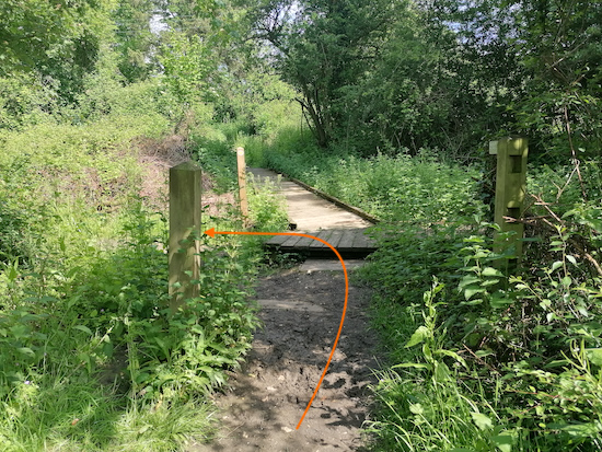
 |
| Take the second footpath on the right leading to a footbridge |
23: The path now bends to the left then heads SSE for 430m back to Cottered village and the starting point.


Hello, we enjoyed this walk a few weeks ago, but got confused at junction 15. I think the photo above junction 14 is actually at junction 15 where you turn SE. There is a footpath approx NE at this point so we ended up doing a short detour. No mud in July / Aug 2022!
ReplyDeleteThanks so much for this great feedback. You are right, one of the photographs was in the wrong place and the text was ambiguous. I have gone through the directions and made several adjustments. It's really nice of you to take the time to tell me.
DeleteI know a lot of people don't bother with my directions and photos and just download the free GPS files and follow them on the free Komoot app, so they won't spot any mistakes, but it's great that you reported back. Thanks again.
Dave