Welcome to Hertfordshire Walker

CPRE Hertfordshire double award winner 2022

Walk 98: Ardeley South-East Loop

5.1 miles (8.2km) with 50m total ascent


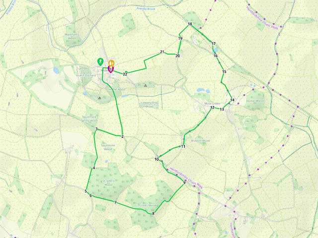
This is a lovely walk to the SE of Ardeley in north Hertfordshire. It follows byways, footpaths and quiet lanes through picturesque open countryside with excellent views. It’s fairly flat for most of the route. There are several gates and footbridges along the way. The Jolly Waggoner pub/restaurant is close to the start/finish point.

Hertfordshire County Council say that due to embankment work being carried out, Ardeley BOAT 10 / Cottered BOAT 34 (byway open to all traffic) heading S and E towards the junction with Cottered 21, for an approximate distance of 100m, will be closed for up to six months from 5 February 2024. They do suggest a diversion, please see map below.

Map courtesy of Hertfordshire County Council


Directions


Map for Walk 98: Ardeley South-East Loop
Click on the map for a larger version
Created on Map Hub by Hertfordshire Walker
Elements © Thunderforest © OpenStreetMap contributors

There is an interactive map below the directions
Those with GPS devices can download GPX or KML files for this walk. We've added What3Words location references for those who use that navigation system. If you print these walks you might want to use the green PrintFriendly icon at the bottom of these directions to delete elements you don't need.

1: With your back to The Jolly Waggoners (location - https://w3w.co/hoops.spell.deposits), and facing Church Farm Cafe (location - https://w3w.co/polices.blinking.terminology), turn right then head W for 110m until you reach School Lane (location - https://w3w.co/robes.regrowth.idealist) on the left.

Turn left on School Lane then follow it for 200m until it turns into a track (location - https://w3w.co/leaned.teardrop.neat). This is Ardeley BOAT 4 (byway open to all traffic). Continue along this byway past Church Farm on the left. The farm is described on its website as “a community interest, not-for-profit social enterprise, set up by its founders in order to innovate and create, replicable and sustainable small farm enterprises”.

Continue down the byway heading S for 750m until you meet a path going off to your right (location - https://w3w.co/gamer.grasp.sporting). This is Ardeley bridleway 9.

The turn at point 2 below leading to Ardeley bridleway 9 Image by Hertfordshire Walker released via Creative Commons BY-NC-SA 4.0
The turn at point 2 below leading to Ardeley bridleway 9
2: Turn right and follow the bridleway, Ardeley bridleway 9, heading WNW for 340m until you reach a path on your left (location - https://w3w.co/jumps.limits.pylon).

3: Take this path, Ardeley footpath 50, which leads down to a metal gate and then across a field, and head S. After 90m the path becomes Walkern footpath 39. After 400m the path turns to the right and then to the left.

The path leading to St John's Wood at point 4 below Image by Hertfordshire Walker released via Creative Commons BY-NC-SA 4.0
The path leading to St John's Wood at point 4 below
4: Continue heading S with the field on your right and the woodland on your left. At the end of the field you meet a lane (location - https://w3w.co/riskiest.spits.stance).

5: Turn left here for 80m looking out for a footpath on your left (location - https://w3w.co/relies.begin.abacus) just after the woodland (St John's Wood).

6: Turn left on this path, Walkern footpath 8, and head SE with the field on your right and the woodland on your left.

7: At the end of the woodland (location - https://w3w.co/outlined.tailwind.perkily) continue straight across the path which now crosses the fields. At the end of the field enter the Lord’s Wood and continue heading SE until you leave the wood via a footbridge (location - https://w3w.co/dispensed.crimson.earplugs).

The footbridge mentioned in point 7 above Image by Hertfordshire Walker released via Creative Commons BY-NC-SA 4.0
The footbridge mentioned in point 7 above
8: Turn left here and head NE with the woods on your left and the field on your right. This is now Ardeley footpath 32. Continue heading NE. Ignore a path on your right after which your path becomes Ardeley footpath 33 and continues NE.

The path mentioned in point 9 below Image by Hertfordshire Walker released via Creative Commons BY-NC-SA 4.0
The path mentioned in point 9 below
9: At end of field (location - https://w3w.co/enormous.norms.stitch) turn left and head NW with field on left and hedge on your right. This is Ardeley footpath 12. Continue for 300m, go through a gap in the hedge, down a dip and up the other side. Then cross a field heading for a white post on the other side (location - https://w3w.co/wipes.notifying.intricate).

The junction mentioned in point 10 below Image by Hertfordshire Walker released via Creative Commons BY-NC-SA 4.0
The junction mentioned in point 10 below
10: Cut through the hedgerow and you will come to a point where two tracks cross. Your way is straight ahead heading NE on Ardeley BOAT 8. Follow this track NE for 380m until you come to a T-junction (location - https://w3w.co/picturing.hypocrite.flipping).

11: Turn left and head N then NE along Ardeley BOAT 51 for 650m until you reach the lane (location - https://w3w.co/crunchy.inventors.gains).

12: Turn right on the lane and head E for 120m looking out for a byway on your left (location - https://w3w.co/heartened.stands.oils).

The byway turn mentioned in point 13 below Image by Hertfordshire Walker released via Creative Commons BY-NC-SA 4.0
The byway turn mentioned in point 13 below
13: Take this byway, Ardeley BOAT 24, and head NE for 180m until you reach the Moor Hall (location - https://w3w.co/blasted.spades.handyman).

14: Turn left and head NW along Honey Lane, which is still Ardeley BOAT 24. Continue for 400m looking out for a footpath on your left (location - https://w3w.co/vouch.sunshine.microchip).

15: Take this path, Ardeley footpath 24, to the end of the field where you take a right turn across a footbridge (location - https://w3w.co/notes.visits.pioneered).

16: Here you turn left and follow the path to the left of the pond. Immediately after the pond, and keeping the pond on your right, head towards a gate in the hedgerow to the right of the telegraph pole (location - https://w3w.co/capillary.fries.cabbies).

17: Go through the gate and turn left on a Roman road. This is Ardeley BOAT 10. Head NW for 380m looking out for a path on your left (location - https://w3w.co/posts.inserting.logbook).

Ardeley footpath 35 mentioned in point 18 below  Image by Hertfordshire Walker released via Creative Commons BY-NC-SA 4.0
Ardeley footpath 35 mentioned in point 18 below
18: Take this path, Ardeley footpath 35, and follow it SW for 230m where you will come to a point where several tracks cross (location - https://w3w.co/piglets.stealing.evoked).

19: Here you turn slightly left then turn right on a track heading S. Continue heading S for 210m looking out for a footpath on your right (location - https://w3w.co/powering.hairstyle.expose).

20: Take this path, Ardeley footpath 34, and head W for 200m until you reach a footpath crossing (location - https://w3w.co/boxing.dent.encroach).

The footpath crossing mentioned in point 20 above Image by Hertfordshire Walker released via Creative Commons BY-NC-SA 4.0
The footpath crossing mentioned in point 20 above
21: Turn left, still on Ardeley footpath 34, and head SW, SSE, then SW again for 660m heading back to Ardeley village. Eventually you reach a lane (location - https://w3w.co/breathing.strikers.recapture).

22: Turn right and head NW back to the village centre.
Interactive map


2 comments:

  1. We enjoyed this walk this morning in the pleasant spring sunshine. Good detailed written instructions and we liked the printer friendly text. We also used the gpx file as backup. Thank you.

    ReplyDelete
    Replies
    1. Hi Beryl,
      So glad you enjoyed it, and thanks for the feedback.
      David

      Delete

Comments and feedback
If you try any of the walks on this site, please let us know what you thought of them. You can either comment here, or on our members-only Facebook Group where walkers are sharing photographs of their walks and walking tips. Comments on our Facebook Group go live immediately, as they do on our Facebook Page. Comments here on our website are moderated, so there will be a slight delay before what you write goes live.

Supported Charity: The Trussell Trust

Supported Charity: The Trussell Trust
Supporting those locked in poverty

Search This Site