5.8 miles (9.4 km) with 112m total ascent
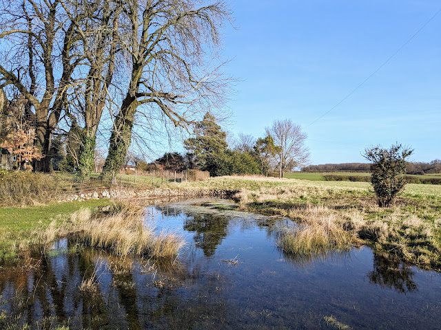 |
| A pond just before point 8 on the walk |
This is a lovely walk over undulating countryside with wide open views. There are well-signposted paths and a stretch along a deep cut waterway hidden by woodland and hedgerow. Apart from one short section this is a quiet walk where you will escape the sound of traffic. If you are lucky you might spot a herd of deer, the odd solitary muntjac, herons, kites, and buzzards. Along the way you will pass several signs urging dog owners to keep their pets on a lead. And you will cross a livestock field where you might meet friendly horses. There are two sections of the walk that can be muddy after rain. If you want refreshments there is a pub/restaurant and a cafe in Wadesmill close to the start and finish points.
Fly through preview of walk
If you want to check what sort of landscape you will be crossing before you set off on this walk you can view a short 3D video of the route below. It's created using the free version of
Relive.
Directions
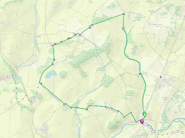 |
Map for Walk 58: The Wadesmill North-West Loop
Click on the map for a larger version
Created on Map Hub by Hertfordshire Walker
Elements © Thunderforest © OpenStreetMap contributors
There is an interactive map at the end of these directions |
Those with GPS devices can download
GPX or
KML files for this walk. We've added
What3Words location references for those who use that system. If you print these walks you might want to use the green
PrintFriendly icon at the bottom of these directions to delete elements such as photographs.
Park in the village of Wadesmill (location -
https://w3w.co/humble.swung.paper). There are several spots where (as of February 2024) you can park free of charge. But do check in case the parking restrictions have changed since this guide was written.
There are two opportunities for refreshments in Wadesmill.
The Feathers pub/restaurant (location -
https://w3w.co/wiring.error.total) and
Ermines Cafe (location -
https://w3w.co/flames.hatch.gazed), both close to the start/finish point.
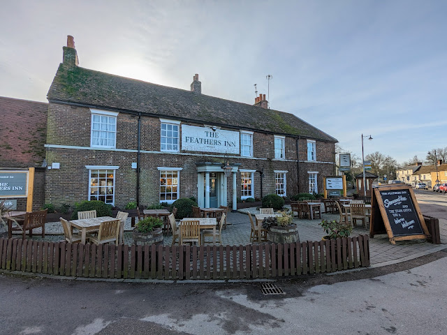 |
| The Feathers, Wadesmill |
1: With your back to
The Feathers (location -
https://w3w.co/verse.spot.outer) turn left then head SW for 75m until you reach a mini-roundabout and Anchor Lane on the right (location -
https://w3w.co/hello.supply.zones), see image below (
note that the pub on the corner has been converted into residential accommodation).
 |
| Turn right on Anchor Lane |
2: Turn right on Anchor Lane then head WSW for 200m until you reach a bridleway on the right (location -
https://w3w.co/hedge.sleep.unions), see image below.
 |
| Turn right on Thundridge bridleway 35 |
3: Turn right on Thundridge bridleway 35 (which looks like it's part of a private drive) then head NNW and uphill for 270m until you reach a junction with a path going off to your left (location -
https://w3w.co/window.global.look), see image below.
 |
| Turn left on Thundridge footpath 37 |
4: Turn left on Thundridge footpath 37 then head SW for 200m until you reach the point where the path bends to the right (location -
https://w3w.co/robe.scare.august), see image below.
 |
| Turn right, still on Thundridge footpath 37 |
5: Turn right, still on Thundridge footpath 37, then head NW and uphill for 210m until the path reaches the hedgerow (location -
https://w3w.co/record.rests.spins), see image below.
 |
| Follow the footpath through the hedgerow |
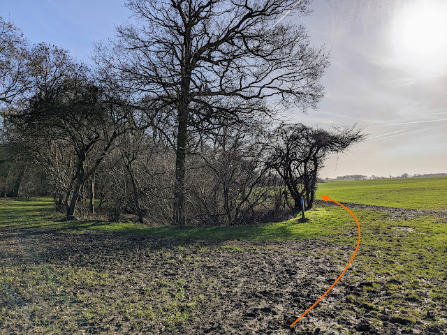
6: When the footpath passes through the hedgerow (see orange arrow on the photograph above) it becomes Bengeo rural footpath 4 which you follow as it heads NW. Along the way you will see signs asking dog owners to keep their pets on a lead, see image below.
 |
| 'Dogs on leads' sign alongside Bengeo rural footpath 4 |
Continue on Bengeo rural footpath 4 for 200m until the path bends to the left (location -
https://w3w.co/speaks.falls.wiping), see image below.
 |
| Follow Bengeo rural footpath 4 as it bends slightly to the left |
7: Follow Bengeo rural footpath 4 NW for 160m until you reach a farm track (location -
https://w3w.co/spoke.epic.desire), see image below.
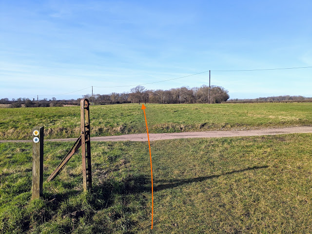 |
| Cross the track then continue heading NW, still on Bengeo rural footpath 4 |
8: Cross the track then continue heading NW, still on Bengeo rural footpath 4, for 370m until you reach woodland (location -
https://w3w.co/able.cooks.divisions), see image below.
 |
| Head SW on Bengeo rural footpath 4 |
9: When you reach the woodland follow Bengeo rural footpath 4 as it heads SW, with the woodland on the right and field on the left, for 120m where the path bends right (location -
https://w3w.co/privately.couch.nets). At this point we stood and watched a herd of deer crossing the field to our left.
10: Continue on Bengeo rural footpath 4 now heading W for 240m until the path enters the hedgerow (location -
https://w3w.co/abode.bells.veal), see image below.
 |
| Follow Bengeo rural footpath 4 through the hedgerow |
11: Follow Bengeo rural footpath 4 through the hedgerow and 50m on down to a junction (location -
https://w3w.co/hours.kinds.costs), see image below.
 |
| Head W, still on Bengeo rural footpath 4 |
Head W, still on Bengeo rural footpath 4, ignoring paths on the left and right (see orange arrow on the image above) and continue with the woodland on the right for 120m until the path turns right into the hedgerow (location -
https://w3w.co/strike.exist.called), see image below.
 |
| Turn right, still on Bengeo rural footpath 4 |
12: Turn right, still on Bengeo rural footpath 4, then head NW for 165m with farm buildings on your left and the field on your right. You will cross a small footbridge (location -
https://w3w.co/insect.usual.notes) before reaching a gate at the end of a building (location -
https://w3w.co/voted.sizes.frames), see image below.
 |
| Turn left, still on Bengeo rural footpath 4 |
13: At the end of the buildings turn left, still on Bengeo rural footpath 4, then head SW for 40m to a junction (location -
https://w3w.co/kick.healers.pushed), see image below.
 |
| Head NW on Bengeo rural footpath 3 |
Turn right at the junction then head NW on Bengeo rural footpath 3. Continue for 870m to a gate (location -
https://w3w.co/sang.report.output) see image below. As you reach this section you will be aware of noise from Ware Road to the left.
.jpeg) |
| Go through the gate then continue heading NW |
14: Go through the gate then continue heading NW for 60m, now on Sacombe footpath 11, until you reach a track (location -
https://w3w.co/hype.poster.beside). Turn right at the track, which is also Sacombe bridleway 12, then head NNE then NE for 560m until you reach a fork in the track (location -
https://w3w.co/peanut.pushes.zest), see image below.
 |
| Keep left at the fork then head NNE |
15: Keep left at the fork, still on Sacombe bridleway 12, then head NNE for 115m to a junction (location -
https://w3w.co/lock.neck.stone), see image below.
 |
| Head straight at the junction, still on Sacombe bridleway 12 |
16: Head straight at the junction, still on Sacombe bridleway 12, and now heading N for 400m until you reach
St Catherine’s Church, a Grade II* listed building which dates back to the 12th century (location -
https://w3w.co/good.doing.during), see image below.
 |
| Enter the churchyard then turn right in front of the church |
17: Enter the churchyard then turn right in front of the church, now on Sacombe footpath 3.
.jpg) |
| St Catherine’s Church, Sacombe |
There are two benches and a picnic table with a view behind the church (location -
https://w3w.co/leads.pirate.fancy) see image below.
 |
| The benches and picnic table with a view at St Catherine’s Church |
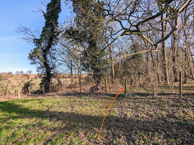
Head ENE on Sacombe footpath 3 through the churchyard for 50m to woodland (location -
https://w3w.co/rats.pushed.vest), see image below.
 |
| Enter the woodland, still on Sacombe footpath 3 |
18: Enter the woodland, still on Sacombe footpath 3, then head E then ENE for 180m until you leave the woodland (location -
https://w3w.co/buck.plan.square), see image below.
 |
| After leaving the woodland head NE and uphill |
19: After leaving the woodland turn right then head NE and uphill for 190m until you reach a fork (location -
https://w3w.co/acute.stamp.flats), see image below.
 |
| Ignore the fork to the left and continue heading NE |
20: Ignore the fork to the left and continue heading NE for another 65m to a gate (location -
https://w3w.co/dress.vision.blast), see image below. When we revisited this walk in February 2024 there was mud either side of this gate making it difficult to get through, but the mud was shallow and we managed to avoid getting too messy.
 |
| Go through the gate then head NE |
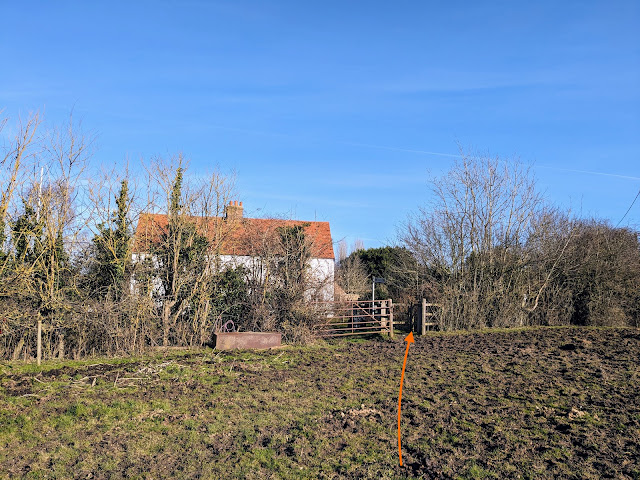
21: Go through the gate then head NE for 120m across a field which, when we visited, was populated by friendly horses. Walk to the right of a white cottage where you will find a gate leading to a lane (location -
https://w3w.co/bits.goad.fool), see image below. This section can be muddy after rain because the horses gather at both gates into the field.
 |
| Once through the gate, turn right on the lane |
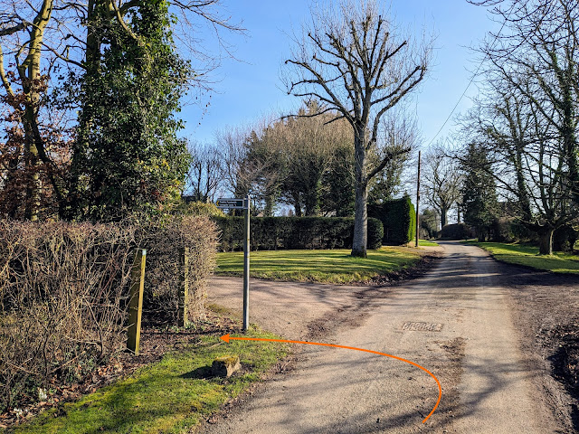
22: Once through the gate, turn right on Sacombe Green Road then head ESE for 35m following the road as it bends left then heads NE for 30m to reach a junction (location -
https://w3w.co/themes.risen.launch), see image below.
 |
| Keep right at the junction then head SE on Marshall's Lane |
Keep right at the junction then head SE on Marshall's Lane for 55m looking out for a footpath on the left (location -
https://w3w.co/dairy.raves.tune), see image below.
 |
| Turn left on Sacombe footpath 2 |
23: Turn left on Sacombe footpath 2 then head NE for 310m until you reach a hedge (location -
https://w3w.co/behave.tree.void), see image below.
 |
| Once through the hedge turn left, still on Sacombe footpath 2 |
24: Once through the hedge turn left, still on Sacombe footpath 2, then head NNW for 45m until you reach a lane (location -
https://w3w.co/moves.reader.opera). Turn right on the lane then head ENE for 80m to a junction (location -
https://w3w.co/shots.nerve.sage), see image below.
 |
| Continue heading straight and ENE at the junction |
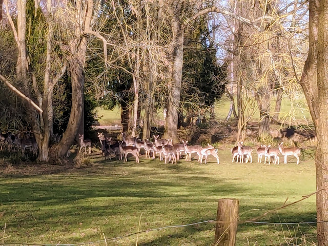
25: Continue heading straight and ENE at the junction, now Sacombe BOAT 1 (
byway open to all traffic). We were lucky to spot a herd of wild deer on our left along this stretch, see image below.
 |
| Wild deer to the left of Sacombe BOAT 1 |
Continue along Sacombe BOAT 1 for 420m until you pass Lowgate Farm on the right at which point the byway you are walking becomes Thundridge BOAT 41. Continue for another 420m until you reach a bridleway on the right, (location -
https://w3w.co/punt.reason.eaten), see image below.
 |
| Turn right on Thundridge bridleway 42 |
26: Turn right on Thundridge bridleway 42 then follow it as it heads S, This section can be muddy after rain. Continue for 370m, crossing a field and continuing until you reach woodland and a left-hand bend (location -
https://w3w.co/palm.buck.fantastic).
 |
| Head in a southerly direction with the woodland on your left |
27: Keeping the woodland on your left and the fields on your right, continue in a southerly direction with The Bourne and woodland on the left and fields on the right for 1.4km until you reach Marshall's Lane (location -
https://w3w.co/yoga.pops.hoot), see image below.
 |
| Cross Marshall's Lane then continue on Thundridge footpath 40 |
28: Cross Marshall's Lane then continue heading in a southerly direction with The Bourne on your left but now on Thundridge footpath 40 for 1.1km until you reach Cambridge Road, Wadesmill, where you turn right to return to the starting point.
As well as the Feathers, there is the option to visit Ermines cafe for refreshments. The cafe is a 105m detour from point 2 in the walk on the left just after the bridge over the River Rib (location -
https://w3w.co/keeps.ladder.pure). Please be sure to check for opening times.
 |
| Ermines Cafe close to point 2 in the walk |
Interactive map


.jpeg)


.jpg)


We have completed this walk a couple of times now and really enjoy the mixutre of open fields and woodland. An enjoyable walk, I would recommend.
ReplyDeleteNice to hear. We enjoyed this walk, too. The rolling countryside in that area is very attractive. Thanks for the feedback.
DeleteDavid
We had a nasty experience with young horses in the field before Sacombe Green. They chased us and wanted to kick and bite our dog. It was lucky there was two of us one could keep the horses away.
ReplyDeleteHi,
DeleteSorry you had a bad experience. The Ramblers site recommends that: "People keeping horses must ensure that their animals don’t cause a danger. As with cattle, they must assess the risk and decide if it’s safe to keep horses in fields with public access. Horses which chase people or otherwise act aggressively should be reported to the local authority."
https://www.ramblers.org.uk/advice/paths-in-england-and-wales/enjoying-the-countryside/animals-and-rights-of-way.aspx
If you want to report the incident you should email the Hertford County Council Rights of Way (ROW) officer for this area, Andrew Burton. As it's a footpath in the parish of Sacombe you should email row@hertfordshire.gov.org and say the email is for the attention of Andrew Burton. Send the link to this walk and give them the name of the footpath (from our directions) where the problem occurred. If you are able to add a What3Words location reference that will help them, too. But I am sure the name of the footpath and the directions on this page will help them identify the field.
David
Hi David I've emailed Andrew Burton Thanks Mary Dupplaw
DeleteHi I've emailed Andrew Burton but email is .uk not .org I think in case anyone else is emailing them. Waiting to see if I get a reply. Thanks Mary
DeleteHi Mary,
DeleteYou are right. My bad. Sorry. Glad you figured it out.
David
Did this walk yesterday on a perfect day for it. Such great open views across the countryside. Saw lots of red kites, butterflies and deer. No mud anywhere during this hot, dry weather but i dont think we would do this after heavy rain. No narrow footpaths or dark bridleways so this will become one of our favourites. So many blackberries to pick and eat along the way too. Very peaceful apart from the one section you mention. Sat outside for a well earned cup of tea and delicious homemade cake at Ermine’s at the end where we’ve been several times on these walks.
ReplyDelete