5.2 miles (8.3 km) with 76m of total ascent
 |
| Osprey Lake between points 7 & 8 in the walk |
This walk circles the Cole Green Way, a long distance path which follows what was once the track of the now disused
Hertford to Welwyn Junction railway line. Our route goes through
Panshanger Park, a
Herts & Middlesex Wildlife Trust nature reserve, which has some great information boards for those wanting to know more about nature.
You will also pass the Historic England scheduled monument,
the Baroque gardens at Grotto Wood, with the option to walk through the woods. Another information board will explain what you will see.
The walk passes
The White Horse pub/restaurant in Hertingfordbury close to the halfway point. Please check for opening times to avoid disappointment. The start point is 2.4 miles WSW from Hertford North station by road.
Getting there
For those travelling by bus there are two options. There are bus stops in Birch Green soon after the start of the walk (location -
https://w3w.co/city.press.powers) which are served by number 324 and 641 buses. There is also a bus stops soon after point 17 (location -
https://w3w.co/shunts.pushy.riding) which are served by the number 380 bus. You can check bus times at
Intalink.
Fly through preview of walk
If you want to check what sort of landscape you will be crossing before you set off on this walk you can view a short 3D video of the route below. It's created using the free version of
Relive.
Directions
 |
Map for Walk 181: Birch Green Loop
Click on the map for a larger version
Created on Map Hub by Hertfordshire Walker
Elements © Thunderforest © OpenStreetMap contributors
There is an interactive map below the directions |
Those with GPS devices can download
GPX or
KML files for this walk. We've added
What3Words location references for those who use that system. If you print these walks you might want to use the green
PrintFriendly icon at the bottom of these directions to delete elements such as photographs.
 |
| Turn right on the permissive path marked 'Cycleway' then head N |
We parked along Birch Green in a section which, at the time of writing, had no parking restrictions (location -
https://w3w.co/soil.zest.washed). But do check in case the situation has changed since this walk was published. You should not park near the school; there are signs advising people to keep that area clear.
1: With your back to the Birch Green village playground (location -
https://w3w.co/stored.arrive.stop), turn right then head N for 160m until you reach The Old Coach Road (location -
https://w3w.co/senses.pouch.scuba). Turn left on The Old Coach Road then head W for 225m ignoring the first footpath on the right and continuing until you reach a
permissive path on the right (location -
https://w3w.co/slower.view.combining) signposted 'Cycleway', see image above.
 |
| The permissive path meets Hertingfordbury footpath 10 before the bridge |
Turn right on the permissive path and follow it N for 295m until you join Hertingfordbury footpath 10 just before a bridge over the A414, see image above.
 |
| Head NW on Hertingfordbury footpath 10 with Forty Acres on the left |
2: Cross the A414 then follow Hertingfordbury footpath 10 as it bends left then heads NW. Ignore a footpath on the right (location -
https://w3w.co/foil.modes.cost) after 130m, and continue heading NW, crossing a quarry track (location -
https://w3w.co/flight.entry.impose), and continuing to another junction (location -
https://w3w.co/mice.famed.forms). Here you will see Forty Acres on the left, with an information board, see images above and below.
 |
| Forty Acres information board, Panshanger Park |
According to the information board:
"Forty Acres is an area of grassland and wetland pools. The area provides nesting places for solitary wasps and bees which dig burrows in the bare ground. The area also provides habitat for migrant birds such as the rare little ringed plover. Ditches and ponds provide breeding places for amphibians such as frogs, toads and newts and in the summer you will see plenty of wild flowers".
Continue heading NW for 385m until you reach a junction (location -
https://w3w.co/claim.safe.fortunate), see image below.
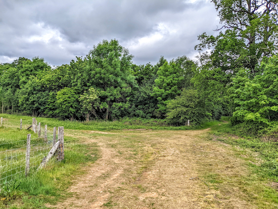 |
| Take the right-hand fork at the junction |
3: Turn right at this junction then follow the path N through woodland for 75m until you reach another junction (location -
https://w3w.co/solid.insert.useful). Keep left at the junction then head NNW then NNE along a winding track for 240m to a junction (location -
https://w3w.co/blunt.loose.combining), see image below.
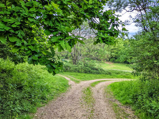 |
| Turn right at the junction then head ENE for 90m |
4: Turn right at the junction then head ENE for 90m to another junction (location -
https://w3w.co/faced.ballots.unity). Turn right then follow the path SE for 870m with the River Mimram and lakes on your left and the woodland on your right. Continue until you reach a junction (location -
https://w3w.co/lawn.dark.forks) just before Kings Lake, see image below.
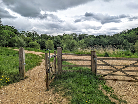 |
| Turn left when you reach Kings Lake |
5: Turn left at the junction then head NNE then N for 260m first with Kings Lake on the right (location -
https://w3w.co/slug.stamp.trying) then Riverside Lake on the left (location -
https://w3w.co/best.many.flag), continuing until you reach a junction (location -
https://w3w.co/bets.bunks.misty), see image below.
 |
| Turn right at the junction then head ENE for 70m |
6: Turn right at the junction then head ENE for 70m until you reach a cattle grid (location -
https://w3w.co/rise.pops.rocky), see image below.
 |
| Turn right after the cattle grid then head E |
 |
| English Longhorn cattle grazing between points 6 & 7 |
* On the day we tested this walk, Monday 23 May 2022, there was a herd of English Longhorn cattle in the field. We have not come across cattle in this field before. We were assured by someone we met at the gate to the field that they were harmless and that we could proceed without any worries, which we did and it was fine. I have since read up about the breed and, apparently, they are 'docile'. However, some might not want to walk through a field of cattle, so I have created a detour, shown on the map below in orange between points 5 an 8. If you use the detour you will avoid the cattle and pick up the route at point 8.
 |
Detour between points 5 and 8
Map created on Map Hub by Hertfordshire Walker
Elements © Thunderforest © OpenStreetMap contributors |
For those not worried about walking through a field of cattle (and keep in mind they might not always be there) turn right after the cattle grid then head E and follow a track for 610m until you reach a gate with Osprey Lake on the right (location -
https://w3w.co/snow.anyone.trip), see image below.
 |
| Turn left before the gate then head NE to a gate on the edge of the woodland |
Turn left just before the gate then head NE for 35m to a footpath gate (location -
https://w3w.co/noble.backs.grid), see image below.
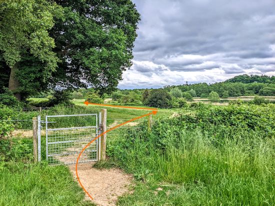 |
| Go through the footpath gate then head E |
Go through the footpath gate then head E for 280m to a junction (location -
https://w3w.co/paint.lovely.meant).
 |
| The entrance to The Dragonfly Trail |
7: Turn right at the junction then head S for 50m to a gate at the entrance to
The Dragonfly Trail (location -
https://w3w.co/answer.shaped.shed), see image above. This is a fascinating area with information boards, hides, and viewpoints along the way. Head SW then S along the trail for 220m until you cross the River Mimram (location -
https://w3w.co/thick.fast.jumped) - see if you can spot crayfish in the water.
 |
| Viewpoint on The Dragonfly Trail |
 |
| Information board on The Dragonfly Trail |
 |
| Information board on The Dragonfly Trail |
 |
| Hide on The Dragonfly Trail |
 |
| Information board on The Dragonfly Trail |
8: After crossing the River Mimram, keep left at the junction then go through the underpass beneath the A414. You are now on Hertford footpath 102, which you follow E, NE, then E for 470m until you reach Hertingfordbury Road (location -
https://w3w.co/parent.belly.ends). Look out for herons on the banks of the River Mimram on your left.
 |
| The White Horse on Hertingfordbury Road |
9: Turn right on Hertingfordbury Road then head S for 200m passing The White Horse pub/restaurant on the right (location -
https://w3w.co/thick.tent.wrong). Check with the pub for opening times to avoid disappointment. When we tested this walk the pub was closed on Mondays and Tuesdays. Continue heading S for 60m to a junction where Hertingfordbury Road bends to the right and St Mary's Lane goes straight ahead (location -
https://w3w.co/loads.beans.over), see image below.
 |
| Keep left at the junction and head along St Mary's Lane |
10: Keep left at the junction and head along St Mary's Lane for 380m, passing
the church of St Mary and St John, a Grade II* listed building, on the left (location -
https://w3w.co/hands.muddy.stuck). Continue along the lane until you reach the bridge carrying the Cole Green Way (location -
https://w3w.co/divisions.backs.emerge).
 |
| Go under the old railway bridge and continue heading S |
At this point there is no pedestrian footpath along the lane, but it is a short stretch and there are opportunities to stand to one side if vehicles approach. Go under the old railway bridge and continue heading S and SSE for 160m until you reach a bridleway on the right (location -
https://w3w.co/copy.spring.pass). As always, walk against the traffic and never on the inside of a blind bend.
 |
| Turn right on Hertford bridleway 57 |
11: Turn right on Hertford bridleway 57 then head SW for 340m at which point the track you are on crosses a parish boundary and becomes Hertingfordbury bridleway 2 (location -
https://w3w.co/sudden.swear.slurs). Continue heading SW, now on Hertingfordbury bridleway 2, for 890m to a junction (location -
https://w3w.co/finger.unwanted.each), see image below. This is a lovely stretch of footpath through woodland and then with open views to the SE.
 |
| Hertingfordbury bridleway 2 meets footpath 3 |
 |
| Head NW on Hertingfordbury footpath 3 |
12: When you reach the junction, turn right on Hertingfordbury footpath 3, see image above, then head NW for 210m until you reach Grotto Wood on the left (location -
https://w3w.co/struck.record.issue), see image below.
 |
| The entrance to Grotto Wood off Hertingfordbury footpath 3 |
* Here you have a choice of taking a short detour through Grotto Wood, however, in the summer this path can become overgrown with nettles and brambles. So if you are walking in shorts you might not want to wander through the wood. The map below shows the detour exploring Grotto Wood in orange. The main route is in green.
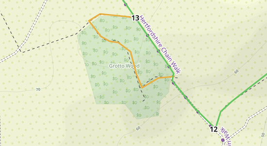 |
The orange line shows the detour through Grotto Wood
Map created on Map Hub by Hertfordshire Walker
Elements © Thunderforest © OpenStreetMap contributors |
It's free of charge to explore the 1.75 hectares of Grotto Wood, which contains “substantial earthworks”.
The following is from the Historic England site:
“The baroque garden in Grotto Wood is a compact and well-preserved example of this monument class, uncommon in that it was independent of its parent residence. The earthworks, undisturbed by subsequent redesign or changes in land use, will retain buried evidence relating to the former garden buildings, the water management system and the planting scheme, and may provide additional information concerning its period of construction and use. Contemporary documents confirm the functions of the various earthwork features and give a clear and vivid impression of the former structures and ornamentation of the established garden, and chart its abandonment and subsequent descent into obscurity. This garden is unusual in that it belonged to members of a disadvantaged religious minority of the merchant class rather than the landed gentry. As such it provides important contrasts with bigger, more famous gardens and allows significant insights into different levels of 18th century society.”
The sign at the gate to Grotto Wood explains what visitors are likely to see when visiting (see image below).
 |
| The sign at the entrance to Grotto Wood |
If you don't take the detour, keep walking NW on Hertingfordbury footpath 3 for 145m until you reach a junction with a footpath joining from the left (location -
https://w3w.co/slimy.trip.jelly). This is the point where the detour through Grotto Wood, marked in orange on the map above, rejoins the main route.
 |
| A lake to the left of Hertingfordbury footpath 3 |
13: Continue heading NW for 460m as Hertingfordbury footpath 3 passes lakes on the left. These are popular with bird watchers at all times of the year. The footpath then bends left at the top of the lakes before joining a byway (location -
https://w3w.co/seat.washed.pills).
 |
| Hertingfordbury footpath 4 off Staines Green |
14: Turn right on Hertingfordbury
restricted byway 19 then head NW, for 85m until you reach a lane called Staines Green (location -
https://w3w.co/duke.before.lied). Turn right on Staines Green, head N for 30m, then take a track on the left (location -
https://w3w.co/trick.charmingly.impact), see image above. At this point we spotted a
Kestrel perched at the top of a tree. This is Hertingfordbury footpath 4, which you follow through two fields, the first heading WNW for 90m with the hedgerow on the right and field on the left, and the second heading NW for 115m, with a fence on the right and field on the left until you reach The Cole Green Way (location -
https://w3w.co/fast.dash.pumps).
 |
| Cross The Cole Green Way then continue on Hertingfordbury footpath 4 |
15: Cross The Cole Green Way then continue heading NW, still on Hertingfordbury footpath 4, for 360m until you reach a residential area. Go through an archway between the houses then continue heading WNW through Foxdells for 120m until you reach Birch Green (location -
https://w3w.co/bless.tell.list), where you turn right then head N for 300m back to the starting point.
If you are in need of refreshments at this point, look out on the right as you reach the end of the walk for the
Four Rivers Coffee (location -
https://w3w.co/frock.voters.uses). Check opening times to avoid disappointment.
Interactive map


Did this walk today and enjoyed it very much. All the nettles and brambles are growing very fast but we manged to get through unscathed but didnt go into Grotto Wood. The Dragon Fly Trail was very interesting and we saw lots of them. We stopped half way at the White Horse and sat in their lovely outside space in the sun. Some great views on this walk and apart from when we were in earshot of the A414 it was very peaceful. The cattle had moved from where you saw them but we have often walked in Panshanger and never been bothered by them and, as you say, they are very docile. Thanks again for all these free walks.
ReplyDeleteSo glad you enjoyed it. We did too. Pity about the noise of the A414, but it's worth putting up with for other benefits the walk offers. Glad you saw some dragonflies. Thanks for the feedback.
DeleteAnother walk which we thoroughly enjoyed. Beautiful scenery.
ReplyDeleteGreat, glad you both enjoyed it. We really liked that walk too.
DeleteWe completed this walk on Friday 1 July and enjoyed it very much. The longhorn cattle had been moved to section 4 - we walked through them without them taking any notice of us. We managed to go wrong at section 7 and initially missed the dragonfly trail, but managed to find it later. We did the detour through Grotto Wood, but it's so overgrown that I'm not sure it's worth it. We may also have gone wrong when we rejoined the main path as we didn't see the lake mentioned at 13. However we successfully completed the rest of the walk.
ReplyDeleteYes, Grotto Wood is usually overgrown at this time of the year. Glad you managed to complete the walk despite missing the lake. I think I know what you probably did. Pleased it didn't spoil the walk. Dave
DeleteWe completed this walk yesterday. Thank you for sharing it. No problems with finding our way. We found it interesting with some lovely views. Good blackberries between points 11 and 12.
ReplyDeleteThanks for the feedback. Yes, it's a lovely walk. Glad you enjoyed it. And I hope the blackberry pie turns out well. :-)
Delete