3.7 miles (6 km) with 83m of total ascent
 |
| Looking back at point 13 in the walk |
This is a lovely walk over rolling countryside south of Benington. The route starts and finishes at The Lordship Arms at Hebing End then explores some wonderful countryside with great views. There are large stretches where the only sound you can hear is birdsong and the occasional plane.
Getting there
Parking is difficult for this walk, but the landlord at
The Lordship Arms told us (in May 2024) that walkers are welcome to use the pub car park if they intend to buy refreshments before or after the walk. Please check with the pub that this hasn't changed. There are limited parking opportunities on some local roads.
For those wanting to travel by bus there is a stop at the start and finish point which is served by the number 38 bus. You can check bus times at
Intalink.
Fly through preview of walk
If you want to check what sort of landscape you will be crossing before you set off on this walk you can view a short 3D video of the route below. It's created using the free version of
Relive.
Directions
 |
Map for Walk 266: Hebing End North-East Loop
Click on the map above for a larger version
Created on Map Hub by Hertfordshire Walker
Elements © Thunderforest © OpenStreetMap contributors
There is an interactive map below these directions |
Those with GPS devices can download
GPX or
KML files for this walk. We've added
What3Words location references for those who use that system. If you print these walks you might want to use the green
PrintFriendly icon at the bottom of these directions to delete elements such as photographs.
 |
| Turn right down a lane called Burn's Green |
1: With your back to
The Lordship Arms (location -
https://w3w.co/comedy.turned.various) turn right then right again along a lane called Burn's Green (location -
https://w3w.co/trophy.baking.starfish), see image below.
Head WSW along Burn's Green for 180m until you reach a fork (location -
https://w3w.co/icicles.embellish.punctuate), see image below.
 |
| Keep right at the fork |
2: Keep right at the fork then head NW for 50m until you reach a footpath on the right (location -
https://w3w.co/plodding.bravery.taxpayers), see image below.
 |
| Turn right on Benington footpath 29 |
3: Turn right on Benington footpath 29 then head N, see image below.
 |
| Continue on Benington footpath 29 to a junction |
Continue heading N on Benington footpath 29 for 285m until you cross a footbridge (location -
https://w3w.co/regal.inner.latitudes) and then reach a gate (location -
https://w3w.co/magical.boomed.insolvent), see images below.
 |
| Cross the footbridge then continue to a gate |
 |
| Go through the gate then enter a livestock field |
4: Go through the gate then continue heading N, still on Benington footpath 26, for 100m across a livestock field until you reach an avenue of trees (location -
https://w3w.co/sweeter.writers.quicksand), see image below.
 |
| Continue on Benington footpath 26 through the avenue of trees |
5: Continue on Benington footpath 26 through the avenue of trees and still heading N for 135m to the point where the footpath bends right to reach a gate leading to Town Lane (location -
https://w3w.co/cookie.pocket.doghouse), see image below.
 |
| The footpath bends right to a gate |
6: After going through the gate turn left on Town Lane then head NNW for 100m until you reach a bridleway on the right (location -
https://w3w.co/solids.surging.lakeside), see image below.
 |
| Turn right on Benington bridleway 22 |
7: Turn right on Benington bridleway 22, which is also a metalled lane, then head NE for 235m where the lane bends left and becomes Benington bridleway 20 (location -
https://w3w.co/cashier.tech.broached), see image below.
 |
| Turn left on Benington bridleway 20 |
8: Follow the lane, which is now
Benington bridleway 20, as it bends left then head N for 30m at which point the bridleway turns left off the metalled lane (location -
https://w3w.co/merge.shares.evidence), see image below.
 |
| Follow Benington bridleway 20 as it turns left |
9: Follow Benington bridleway 20 as it turns left leaving the metalled lane before heading NW for 35m to the right of a tree after which the bridleway turns right then heads N across an arable field (location -
https://w3w.co/revamping.resting.serve), see images below.
 |
| Benington bridleway 20 going to the right of the tree |
 |
Benington bridleway 20 heading N across a field
|
10: Continue heading N on Benington bridleway 20 for 265m until you reach hedgerow (location -
https://w3w.co/traded.rejoins.joints), see image below.
 |
| Keep to the left of the hedgerow |
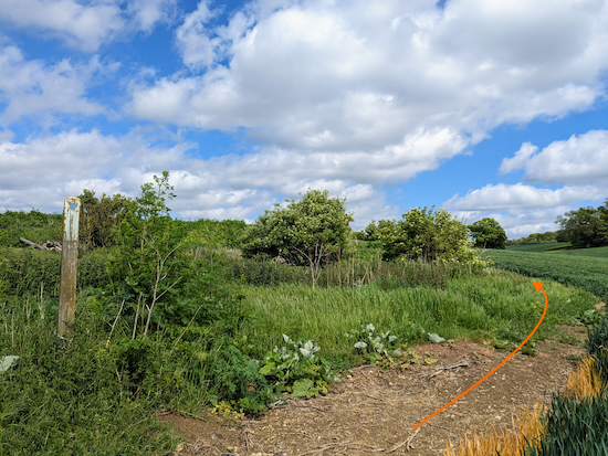
11: Continue on Benington bridleway 20, and keeping to the left of the hedgerow. Continue now heading NNE with the hedgerow on the right and field on the left for 315m until the bridleway cuts to the right then turns left (location -
https://w3w.co/widely.joints.business), see the orange line on the image below.
 |
| Continue on Benington bridleway 20, now heading NE |
12: Continue on Benington bridleway 20, now heading NE, for 110m until you reach a track (location -
https://w3w.co/encodes.manifests.wharfs), see image below.
 |
| Follow Benington bridleway 20 uphill |
13: Cross the track then continue to follow Benington bridleway 20 uphill and ENE for 85m until you skirt round a disused pit on your left (location -
https://w3w.co/broadens.resonates.remove), see images below.
 |
| Benington bridleway 20 skirts round the disused pit |
 |
| Before heading NE across an arable field |
14: Continue heading NE on Benington bridleway 20 for 270m until you reach a junction (location -
https://w3w.co/scars.arranger.migrants), see image below.
 |
| Turn left on Walkern bridleway 7 |
15: Turn left on Walkern bridleway 7 then head NE, with the hedgerow on the left and field on the right 490m until you reach a farmyard (location -
https://w3w.co/fairness.seeing.enthused).
16: Continue heading NE through the farmyard on Walkern bridleway 7 until you reach a white building (location -
https://w3w.co/mass.about.clockwork), see orange arrow on the image below.
 |
| Turn right at the white building |
17: Turn right at the white building then head ESE for 80m where the track bends left (location -
https://w3w.co/started.slices.roosters), see image below.
 |
| Turn left then head NNE for 55m |
Follow the track NNE for 55m before it bends to the right turning right (location -
https://w3w.co/entrusted.reason.relegate). See a map of the route through the farmyard below.
 |
| The route through the farmyard |
18: Head ESE now on Walkern bridleway 2 for 355m until you reach a footpath on the right (location -
https://w3w.co/brief.glares.vies), see image below.
 |
| Turn right on Walkern footpath 40 |
19: Turn right on Walkern footpath 40 then head S for 165m until the footpath bends left then cuts through the hedgerow (location -
https://w3w.co/pages.stormed.roadways), see image below.
 |
| Continue heading S on Walkern footpath 40 |
20: Continue heading S on Walkern footpath 40 with the hedgerow on the right for 690m until you reach a gate (location -
https://w3w.co/splint.ethic.good), see image below.
.jpeg "Go through the gate then continue on Benington footpath 27") |
| Go through the gate then continue on Benington footpath 27 |
21: Go through the gate then head straight and SW on Benington footpath 27 with a brook on the right.
Continue for 275m until the path bends right to cross the brook before bending left to continue heading SW (location -
https://w3w.co/shunning.gently.prospered), see orange arrow on the image below.
 |
| After crossing the brook continue heading SW |
22: After crossing the brook continue heading SW, still on Benington footpath 27 for 390m until you reach a small copse (location -
https://w3w.co/smallest.bulky.project), see image below.
 |
| Benington footpath 27 continues heading SW |
23: Benington footpath 27 continues heading SW to the left of a small patch of woodland (see orange arrow on the image above) but the path was overgrown with nettles when we tested this route on 23 May, 2024. Other walkers had clearly taken a detour shown with a yellow arrow on the image above.
The official route, Benington footpath 27, continues through nettles for 50m to a rickety bridge that needs attention, see image below.
 |
| The bridge on Benington footpath 27 |
We continued to cross the bridge, but it was clear that other walkers had avoided this section by taking a detour (indicated with the yellow arrow on the map below).
 |
| The detour marked in yellow on the image above |
* The first part of the detour, which heads NW from point 21, is an unofficial track but, which, after 70m joins a public right of way beyond the copse then heads SE on Benington bridleway 11 to rejoin the official route at point 24. Both the overgrown public right of way and the rickety bridge have been reported to Hertfordshire County Council's rights of way team, by us, using the helpful online form.
 |
| Head SE on Benington bridleway 11 |
24: After crossing the footbridge turn left then head SE on Benington bridleway 11 for 125m, with the brook on your left, until you reach a junction (location -
https://w3w.co/practical.unloads.alike), see image below.
 |
| Turn right at the junction on Benington bridleway 22 |
25: Turn right at the junction on Benington bridleway 22 then head SW for 40m to another junction (location -
https://w3w.co/loft.puts.haystack), see image below.
 |
| Keep left on Benington bridleway 25 |
26: Keep left at the junction then head SW on Benington bridleway 25 then head SW, with the hedgerow on the right and field on the left, for 280m where the bridleway bends right to cut through hedgerow (location -
https://w3w.co/cubic.sanded.drags), see image below.
 |
| Go through the gap then continue on Benington bridleway 25 |
27: Go through the gap then continue heading SW, still on Benington bridleway 25, for 265m until you reach a junction (location -
https://w3w.co/tram.cabbage.terribly), see image below.
 |
| Turn right at the junction then head NW |
28: Turn right at the junction then head NW for 90m, still on Benington bridleway 25, until you reach a junction (location -
https://w3w.co/obscuring.girder.crunches), see image below.
 |
| Turn left then follow a lane back to the starting point |
29: Turn left at the junction then follow a lane WSW for 340m back to The Lordship Arms and the starting point.
Interactive map


.jpeg "Go through the gate then continue on Benington footpath 27")


I did this walk on Sunday, following a night of rain. It was muddy, which was to be expected, but the puddles in the fields created mirrors which reflected the sunlight and added to the peace and tranquility of the walk. I did find some on-road parking on Town Lane (direction No. 6 above).
ReplyDeleteA lovely and enjoyable Sunday walk. Thank you. - Steve -
Thanks fo the feedback, Steve. Glad you enjoyed the walk. David
DeleteBeautiful walk 2.6.25 on a sunny day but at point 5 be warned it’s very boggy underfoot !
DeleteHi, glad you enjoyed the walk despite the boggy bit. Thanks for the feedback. David
DeleteLovely walk with some good views! However, the crossing of the arable field in point 9 was hard going as it was very overgrown with long grass, weeds and nettles etc. I managed to pick up a tick here so check yourself on this one! Points 20-21 was hard work due to the very long grass and the fact it was quite a long section.
ReplyDeleteHi Gerry, thanks for the update. Sorry to hear about the tick. David
ReplyDelete