Welcome to Hertfordshire Walker

Download and enjoy our FREE walks

Showing posts with label 0m-25m. Show all posts

Walk 289: St Albans to Redbourn Linear

5.3 miles (8.5 km) with 20m of total ascent


The River Ver before point 10 in the walk
This linear route follows sections of both The Hertfordshire Way and The River Ver Trail connecting St Albans and Redbourn. The route weaves alongside the River Ver through some lovely countryside. However there are days when walking this route is not possible because a section of The Hertfordshire Way will be closed to the public, details below.

Walk 284: Rabley Heath North Loop

2.5 miles (4 km) with 21m of total ascent


The view from Codicote bridleway 25 at point 7
This is our second walk from Rabley Heath and is one of the shortest in the Hertfordshire Walker collection. It follows well-defined footpaths, bridleways, and quiet country lanes across some lovely countryside. The walk starts and finishes at The Robin Hood & Little John pub at Rabley Heath then passes close to The Lytton Arms which involves a 525m detour at point 6 in the walk.

Walk 263: Stapleford East Loop

3.1 miles (5.1 km) with 24m of total ascent


Sacombe footpath 15 between points 8 & 9
This is a really lovely and easy walk along the valley of the River Beane. It includes rights of way that feature in other walks in our collection but they are walked in reverse, which results in a totally new walking experience.

Walk 247: Nast Hyde Halt Loop

3.8 miles (6.2km) with 5m of total ascent


Nast Hyde Halt on The Alban Way
We have created this short loop to enable walkers to explore the lovingly restored Nast Hyde Halt along The Alban Way, the route of the former Hatfield to St Albans railway line. You will start at Smallford Station, pass Nast Hyde Halt, then loop around Ellenbrook Fields, which is the site of the former Hatfield Aerodrome. There is one short stretch along the western edge of Hatfield and past the university, but you are soon into open fields with excellent views.

Walk 242: Smallford North Loop

4.5 miles (7.3 km) with 24m total ascent


Colney Heath footpath 14 between points 6 & 7
This is a perfect walk if you are getting your car serviced along Hatfield Road and need to kill a few hours while the mechanics are doing their stuff. The route starts and finishes at what was Smallford Station on the former Hatfield to St Albans railway line, now The Alban Way. There is free car parking at the site (at the time of writing - August 2023). Along the way you will cross livestock fields and a farmyard where there are signs asking dog owners to keep their pets on a lead.

Walk 189: Datchworth Short Loop

2.3 miles (3.7 km) with 13m of total ascent


The view between points 4 & 5
This is a short loop from Datchworth Green which we have created in response to a number of followers of Hertfordshire Walker who asked for shorter routes. A few of the rights of way used in this walk also feature in some of our longer routes but walked in reverse, so the views will be different. This walk involves a stretch along a country lane, but it is quiet and there are opportunities to step aside in the case of traffic.

Walk 161: Sawbridgeworth South Linear

4.5 miles (7.3 km) with 11m of total ascent
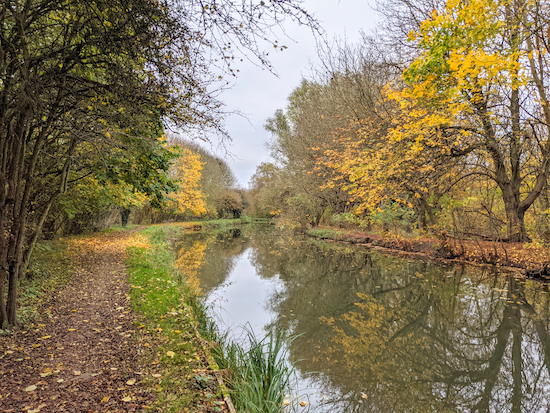

The River Stort (Navigation) along Walk 161
This is a linear walk from Harlow Station to Sawbridgeworth Station, mostly following the towpath alongside the River Stort (Navigation) towpath. There are regular train services connecting the two towns. The first part of the walk is alongside industrial units, but you are soon into open countryside. Birdwatchers should take their binoculars. The walk starts in Essex, close to the Hertfordshire border, then dips in and out of both counties before ending in Hertfordshire.

Walk 64: Gustard Wood Loop

1.5 miles (2.3 km) with 22m total ascent


Photograph of path through the bluebells in Lamer Wood Image by Hertfordshire Walker released under Creative Commons BY-NC-SA 4.0
The bluebells in Lamer Wood picture taken April 29, 2018
This is a great walk at Easter when wild daffodils spread a yellow carpet either side of the path through Lamer Wood. A few weeks later it’s the turn of the bluebells to flood the area with light blue. Amazing how the same woodland can change so much in the space of a few weeks. All year round it’s a popular spot for woodland birds.

Walk 60: The Sculpture Trail

0.6 miles (1 km) with 17m of total ascent


Photograph of sculptures along Walk 60 by Hertfordshire Walker released via Creative commons BY-NC-SA 4.0
 
The Sculpture Trail is ideal for children and those who are finding long walks and lots of ups and downs too much. It's a gentle walk, with lots to see and plenty of benches for rests. Ideal for the young and old of heart.

Walk 49: Ayot Short Loop

1.6 miles (2.6 km) with 19m total ascent


The ruins of the old St Lawrence Church
A pleasant and easy walk around the north side of the village of Ayot St Lawrence circling Ayot Park and passing Shaw’s Corner the former home of the author George Bernard Shaw. You will pass the new St Lawrence Church and the ruins of the old St Lawrence Church. The walk starts and finishes at The Brocket Arms pub/restaurant which has a lovely beer garden. 

Walk 24: Lee Valley Middle Loop

3 miles (4.8 km) with 10m of total ascent


Barges from the bridge between points 11 & 12
Barges from the footbridge between points 11 & 12
This short walk explores part of the middle section of the Lee Valley Regional Park. The entire park is 26 miles long and covers 10,000 acres. It was created to act as a “green lung” for Hertfordshire, Essex, and London. This short walk is the first of three we have planned in this area. The others will explore the southern and northern sections. Please be aware that many of the tracks along this route are shared with cyclists and horse riders. If you are into birdwatching be sure to take your binoculars on this walk.

Walk 3: Water End Loop

2.9 miles (4.7 km) with 22m total ascent


The footbridge mentioned at point 10
A gentle circular walk from Brookmans Park Station to Water End and back. There is a pub called Brookmans at the start and finish, and The Woodman Inn at the halfway point. There are also cafes, restaurants, and shops in Brookmans Park. About a third of the walk is along lanes so if you have dogs or children you might want to pick another route.

Facebook group rules

Facebook group rules
We have set 10 rules for our Hertfordshire Walker Facebook group which are designed to help keep the group focused on walking in the Hertfordshire countryside

Promoted charity: The Trussell Trust

Promoted charity: The Trussell Trust
Supporting those locked in poverty