Welcome to Hertfordshire Walker

Download and enjoy our FREE walks

Showing posts with label Brookmans - Brookmans Park. Show all posts

Walk 269: Gobions South Loop

3.6 miles (5.8 km) with 99m of total ascent


North Mymms footpath 11 soon after point 5 in the walk
This walk explores the rolling countryside south of Brookmans Park. It cuts through a nature reserve that was once the ornamental gardens of a large country manor and passes two WWII pill boxes which are remnants of the Outer London Defence Line. You will cross the abandoned Potters Bar golf course which has been left to grow wild. You will cross some livestock fields.

Walk 179: Swallow Holes Loop

4.5 miles (7.3 km) with 63m of total ascent


A swallow hole in Gobions Wood
A sink hole in Gobions Wood
This walk was inspired by a day spent with geologist Michael Howgate, chair of the Amateur Geological Society. Michael, who leads guided tours in London, Hertfordshire and Essex, kindly agreed to take us on a walk around North Mymms so that we could create a route that passed a number of swallow holes and sink holes in Gobions Wood and at Water End.

Walk 86: Hadley Wood to Brookmans Park Linear

7 miles (11.15 km) with 206m total ascent


The start of the footpath from point 4 Image copyright Hertfordshire Walker released under Creative Commons BY-NC-SA 4.0
The start of the footpath from point 4
A 7-mile linear station-to-station walk from Hadley Wood Station to Brookmans Park Station via the village of Northaw where the walk can be broken for refreshments at the Two Brewers pub/restaurant. This walk can be done in reverse starting from Brookmans Park Station. This walk is hilly and parts, particularly between points 2 and 3 and 6 and 7 can be muddy after rain.

Walk 85: North Mymms Park South Loop

7.1 miles (11.4km) with 101m of total ascent


Hawkshead Wood mentioned at point 18 Image copyright of Hertfordshire Walker released under Creative Commons BY-NC-SA 4.0
Hawkshead Wood mentioned at point 18
This walk is a mix of peaceful remote locations and sections walking alongside the busy M25 and A1(M) motorways. The reason we have included the two sections close to major roads is that it enables walkers to follow a loop that takes in the southern part of North Mymms Park. This is a fairly stretching hike with a fair amount of uphill walking.

Walk 72: Essendon to North Mymms Linear

7.8 miles (12.5 km) with 158m of total ascent


The bridleway between points 4 and 5
This walk starts in the village of Essendon, drops down to the Lea Valley, follows the Lea Valley Walk W for about a mile before heading S through the rolling countryside between Essendon, West End, Wildhill, and Bell Bar. There are two end options, Brookmans Park Station or Welham Green Station.

Walk 71: Welham Green to Brookmans Park Linear East

3.6 miles (5.8 km) with 64m of total ascent


Photograph of The restricted part of the byway along Foxes Lane running from Welham Green to Bulls Lane Image by Hertfordshire Walker released under Creative Commons BY-NC-SA 4.0
 
This walk starts at Welham Green station and follows old footpaths and lanes to Bell Bar, once a busy stopping point for horse-drawn stage coaches travelling between London and the north. It then continues via Gobions Open Space and Gobions Pond to Brookmans Park station.

Walk 70: Welham Green to Brookmans Park Linear West

4.1 miles (6.7 km) with 67m total ascent


Poppies in the field described in point 5 below
This walks starts at Welham Green station, climbs to a trig point with excellent views to the south and west, drops down to follow the route of the old Dellsome Lane, now reduced to a footpath, passes North Mymms Park, and returns to Brookmans Park via the swallow holes at Water End. The route covers part of a much longer walk on this site, the 12-mile North Mymms Way. The start and finish points can be reached by bus or train.

Walk 69: Brookmans Park South-East Linear

3.5 miles (5.70 km) with 75m of total ascent


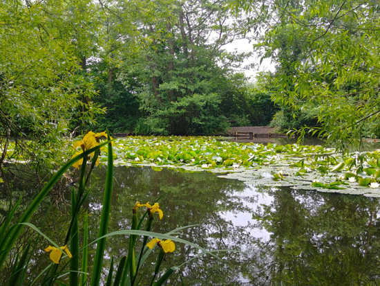
Yellow flag and water lilies on Gobions Pond towards the end of the walk
This is our second linear walk from Potters Bar station to Brookmans Park station. The first, Walk 68, returned via the west side of the railway track skirting both Furzefield Wood and Brick Kiln Wood. This walk returns via the east side of the railway track, crosses the former Potters Bar golf course, and passes through Gobions Wood.

On the way across the old golf course you will come across two WWII pillboxes. The journey between the start and finish points can be by train or by catching the 610 bus.

Walk 68: Brookmans Park South-West Linear

3.3 miles (5.3 km) with 39m total ascent


Photograph of the footpath 15 as it runs west along the north side of Potters Bar Brook  Image by Hertfordshire Walker released under Creative Commons BY-NC-SA 4.0
Footpath 15 as it runs west along the north side of Potters Bar Brook
A walk from Potters Bar station to Brookmans Park station. The route passes by Furzefield Wood and Brick Kiln Wood. The journey between start and finish points can be by train or by catching the 610 bus. The walk starts along the edge of the railway, and cuts through an industrial estate before passing through open countryside.

Walk 50: Bayford - North Mymms Linear

8.6 miles (13.8 km) with 224m total ascent


Photograph of the footbridge through Bayford Wood on Walk 50: Bayford Linear
Bayford Wood
A linear walk from Bayford station going through Bayford, across fields and through woodland to Howe Green, over the golf course to Essendon, via West End, down to Wildhill via a secluded byway, and west over the fields via Bell Bar to Brookmans Park or Welham Green.

Walk 32: Brookmans Park South-West Loop

7.8 miles (12.5 km) with 140m total ascent


Photograph of fields and trees on Walk 32: Brookmans Park SW Loop
 
An undulating walk heading S from Brookmans Park through a local nature reserve, across a disused golf course, over a pine wood hill, and back to Brookmans Park. The route involves quite a bit of hill climbing and some paths can be muddy after rain.

Walk 23: Hatfield-Wildhill-Brookmans Park

8.5 miles (13.7 km) with 182m total ascent


Image taken along Walk 23: Hatfield-Wildhill-Brookmans Park by David Brewer and released under Creative Commons
 
A station-to-station linear walk from Hatfield station, along the Lea Valley and over to West End, Essendon and then via Wildhill to Brookmans Park. Ideal if you want to leave the car at home and have a few pints along the way. The route can be muddy in places after rain. Some gentle hill climbing involved.

We have archived this walk becaue the crossing of the A414 dual carriageway at point 6 has become too dangerous. Sorry about that. Please choose another walk from the 290+ that are free to download. Thanks.

Walk 22: The North Mymms Way

11.8 miles (19 km) with 234m total ascent


Photograph of The path along Foxes Lane near Welham Green mentioned in point 13 below Image by Hertfordshire Walker released under Creative Commons BY-NC-SA 4.0
The path along Foxes Lane near Welham Green mentioned in point 13 below
A half-day walk, keeping, as close as possible using public footpaths, bridleway, byways, permissive paths, and quiet lanes to the boundary of the historic parish of North Mymms in south Hertfordshire, which is mentioned in the Domesday Book. Allow four to five hours.

Walk 19: Welham Green South Loop

4.6 miles (7.4 km) with 32m total ascent


Approaching point 24 near the end of the walk
This walk is another in our collection of walks for those who want like to leave the car at home and travel by train. It starts and finishes at Welham Green Station and passes close to Brookmans Park Station, which is an alternative start and finish point.

About a third of the route is either through built-up areas (close to Welham Green Station) or along lanes and a road which has a pedestrian pavement. Because of this, dog owners might want to choose a different walk from the collection.

The walk passes The Woodman Inn at Water End and close to two other pubs along the way. There are cafes, restaurants, and shops in both Welham Green and Brookmans Park.

Walk 16: North Mymms Ridge Loop

6 miles (9.6 km) with 105m total ascent


Mymmshall Woods between points 10 & 11
This is a good hill walk that starts and finishes at Brookmans Park Station. At one point the route follows an old coaching road from South Mimms to North Mymms and crosses the secluded Potwells valley. There is a short part that is alongside the A1(M), but it is soon over. 

Walk 10: Brookmans Park Long Loop

7.1 miles (11.4 km) with 88m total ascent


North Mymms footpath 11 at point 29 in the walk
This walk offers some great views of the rolling countryside around Brookmans Park following good footpaths and passing by or close to a number of local pubs. The route takes you through the middle of Gobions Wood, which is managed by the Herts and Middlesex Wildlife Trust. The walk starts and finishes at Brookmans Park Station.

Walk 3: Water End Loop

2.9 miles (4.7 km) with 22m total ascent


The footbridge mentioned at point 10
A gentle circular walk from Brookmans Park Station to Water End and back. There is a pub called Brookmans at the start and finish, and The Woodman Inn at the halfway point. There are also cafes, restaurants, and shops in Brookmans Park. About a third of the walk is along lanes so if you have dogs or children you might want to pick another route.

Facebook group rules

Facebook group rules
We have set 10 rules for our Hertfordshire Walker Facebook group which are designed to help keep the group focused on walking in the Hertfordshire countryside

Promoted charity: The Trussell Trust

Promoted charity: The Trussell Trust
Supporting those locked in poverty