10.2 miles (16.5 km) with 210m of total ascent
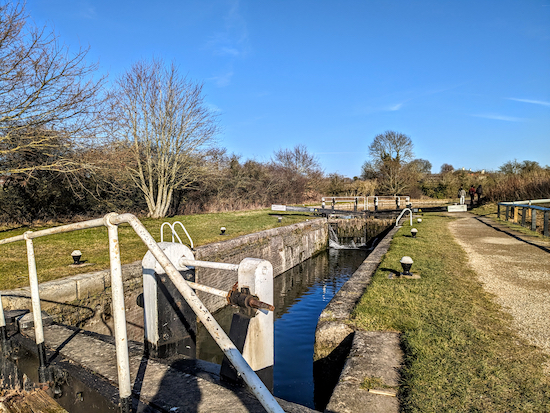
 |
| The route between points 26 & 27 |
This is a wonderful loop around the town of
Tring. The route has a bit of everything. You will walk alongside canals, through woodland, climb to excellent view points, and follow quiet country lanes. The first quarter is flat, the second is almost all uphill, the third quarter is a mix of up and down, and the final leg is flat.
Getting there
Those wanting to access this walk via public transport could catch the train to Tring Station (location -
https://w3w.co/growl.scream.defensive), which is 300m from point 5 in the directions. If you are travelling by bus, the number 167 bus stops close to the start and finish of the walk (location -
https://w3w.co/compliant.pastels.deadline). You can check bus times at
Intalink.
You will pass through a new housing development between points 23 and 24, and alongside 300 acres of
green belt land between points 4 and 5 which
CPRE Hertfordshire says is threatened with 1,400 dwellings which would
"increase the population by 30%, adding around 3,400 more people and 2,000 more cars, adding immense pressure on the infrastructure of Tring and the whole surrounding area."
There is a pub at the start and finish point, one along the way, and two a short detour from the route.
This is the fourth walk in our collection that explores the
Tring Reservoirs Nature Reserve and
The Grand Union Canal. The others are:
Fly through preview of walk
If you want to check what sort of landscape you will be crossing before you set off on this walk you can view a short 3D video of the route below. It's created using the free version of
Relive.
Directions
 |
Map for Walk 228: Tring Loop
Click on the map above for a larger version
Created on Map Hub by Hertfordshire Walker
Elements © Thunderforest © OpenStreetMap contributors
There is an interactive map below these directions |
Those with GPS devices can download
GPX or
KML files for this walk. We've added
What3Words location references for those who use that system. If you print these walks you might want to use the green
PrintFriendly icon at the bottom of these directions to delete elements such as photographs.
Park in the Startop's End car park (location -
https://w3w.co/rents.thumbnail.backed). The rates for the car park when we visited in February 2023 were £2.50 for three hours and £4 for 24 hours. We recommend you pay for 24 hours. The walk took us almost five hours allowing for a 20-minutes break at the halfway point and stopping to take photographs for these directions.
 |
| Startop's End car park charges |
1: From the car park take the footpath that runs between
Startop's End Reservoir and the
Grand Union Canal. This is
Marsworth footpath 13, which starts at a gate in the southern end of the car park (location -
https://w3w.co/convinced.stove.tidal), see image below.
 |
| The footpath heading south from the car park |
Head SSE for 250m until you reach a junction (location -
https://w3w.co/atoms.posting.broached), see image below.
 |
| Take the left fork with the reservoir on the right and the canal on the left |
2: Take the left fork and head ENE along the towpath of The Grand Union Canal and follow it for 1.4km passing a series of locks until you reach the B488 (location -
https://w3w.co/trudges.edgy.badge).
 |
| One of the locks between points 2 & 3 |
 |
| The reservoirs are popular with bird watchers |
3: When you reach the B488 you have the option of turning right to visit
The Grand Junction Arms. If you don't visit the pub, continue along the towpath and head SE with the canal on your left for 960m until you reach a bridge carrying Marshcroft Lane over the canal (location -
https://w3w.co/losing.intent.backlog), see image below.
 |
| Turn left over the bridge then turn right on the towpath |
4: Leave the towpath then turn left over the bridge crossing the Grand Union Canal then turn right (location -
https://w3w.co/available.senses.gashes) and continue following the towpath SE, but now with the canal on your right, for 1.2km until you reach Station Road, Tring (location -
https://w3w.co/foam.cobbles.withdraws), see image below. This is the point where you would join the walk if you decided to travel by train to Tring Station (location -
https://w3w.co/according.today.mule).
 |
| Leave the towpath then turn right over the bridge |
5: Leave the towpath then turn right, cross a bridge over the Grand Union Canal, then turn left along Beggars Lane which heads SSE immediately after the bridge (location -
https://w3w.co/intervals.dwarf.dive). Regular users of our site will recognise the next section if they had previously walked
Walk 158: Wiggington E Loop.
Head down Beggars Lane for 160m. There isn't a pavement along this stretch. Continue until you reach a footpath on the right (location -
https://w3w.co/status.paradise.shook). This is
The Ridgeway, see image below.
 |
| Turn right on The Ridgeway, which is also Aldbury footpath 66 |
6: Turn right on The Ridgeway, which is also Aldbury footpath 66 along this stretch, then head SW for 810m until you reach the A4251,
Akeman Street, a former Roman road (location -
https://w3w.co/thrusters.haggle.scarred), see image below.
 |
| Cross the A4251, then follow the path on the other side |
7: Cross the A4251, then follow the path on the other side, Wigginton footpath 14, uphill as it weaves its way WSW for 240m until you reach a footbridge over the A41 (location -
https://w3w.co/lies.attic.tunes). Cross the footbridge then continue heading SW, still on Wigginton footpath 14 and The Ridgeway, for 520m until you reach a lane called The Twist (location -
https://w3w.co/lyricist.durations.quality), see image below.
 |
| Turn right on lane then take a footpath on the left |
8: Turn right on The Twist then head NW for 25m until you reach a footpath on the left (location -
https://w3w.co/quality.caressed.lemons). Take this path, which is still The Ridgeway and also Wigginton footpath 20, then head SW then WSW. After 340m you will pass a
trig point on the left of the footpath (location -
https://w3w.co/udder.reclaimed.offhand), see image below.
 |
| The trig point alongside The Ridgeway |
Continue for another 160m until you reach Fox Road, Wigginton (location -
https://w3w.co/opts.wooden.backed), see image below.
* If you want refreshments you could turn left on Fox Road and take a 750m detour to visit The Greyhound pub/restaurant at the corner of Wick Road and Chesham Road (location - https://w3w.co/essays.preoccupied.promises).
 |
| Cross Fox Road then head WNW along The Ridgeway |
9: Cross Fox Road then head WNW along The Ridgeway, which is also Wigginton footpath 18 at this point, for 70m until you reach a footpath junction (location -
https://w3w.co/signified.clown.loafer), see image below.
 |
| Continue heading WNW along The Ridgeway |
Head WNW along The Ridgeway, which is also Tring Town footpath 21 along this stretch. Continue for 90m until you reach a footpath junction (location -
https://w3w.co/copying.shuttled.grant), see image below.
 |
| Turn left to stay on The Ridgeway |
10: Turn left on Tring Town footpath 85, which, at this stage is both The Ridgeway and
The Icknield Way, then head SW then SSW for 1.5m. There is an excellent view point on the right along this stretch, and, if you have children with you, look out for the 'Natural Play Area' on the left, see image below.
 |
| The 'Natural Play Area' alongside The Ridgeway |
Continue along The Ridgeway until you reach Martin Hill (location -
https://w3w.co/enrolling.amazed.bets), see image below.
 |
| Go through the gate then turn left on Martin Hill |
11: Go through the gate and continue to a lane called Martin Hill where you turn left then head S for 190m to a junction (location -
https://w3w.co/sweetener.name.nutrients).
 |
| Turn right on Church Lane |
12: Turn right on Church Lane, which is also The Ridgeway along this stretch, then head W then WSW for 590m to a junction (location -
https://w3w.co/trifling.tile.pronouns), see image below.
 |
| Turn left at the junction then take the track on the right |
13: Turn left at the junction then take the track on the right (location -
https://w3w.co/support.blurs.scan). This is Tring Town BOAT 75 (
byway open to all traffic), which you follow NW for 280m until you reach a junction in front of a cottage (location -
https://w3w.co/firework.rejoiced.terms), see image below.
 |
| Take the byway, Tring Town BOAT 74, to the left of the cottage |
Take the byway to the left of the cottage and continue heading NW, now on Tring Town BOAT 74, for 85m to another junction (location -
https://w3w.co/lighters.drops.nuance), see image below.
 |
| Tring Town BOAT 74 now heads N |
14: Tring Town BOAT 74 now heads N for 225m to a junction (location -
https://w3w.co/mocking.intruders.loitering), see image below.
 |
| Turn sharp left at the junction then head SSW |
15: Turn sharp left at the junction on Tring Town
bridleway 27 then head SSW for 230m to another junction (location -
https://w3w.co/moment.pies.published), see image below.
 |
| Turn sharp right and then head NNW on Tring Town BOAT 36 |
16: Turn sharp right and then head NNW on Tring Town BOAT 36 for 280m to a junction (location -
https://w3w.co/undercuts.dart.curve), see image below.
 |
| Continue on Tring Town BOAT 36 for 340m |
17: Continue on Tring Town BOAT 36 for 340m until you reach Duckmore Lane (location -
https://w3w.co/photo.hesitate.reassured).
We stopped for a picnic just through the gate on the image above. It was a lovely spot with uninterrupted views across the Chilterns.
 |
| Cross Duckmore Lane then continue on Tring Town BOAT 36 |
18: Cross Duckmore Lane then continue heading NNW, still on Tring Town BOAT 36, for 650m until you reach a bridge over the A41 (location -
https://w3w.co/freshen.overlaps.defeated).
19: Cross the A41 then head NNE, still on Tring Town BOAT 36, for 190m until you reach the B4635, Aylesbury Road (location -
https://w3w.co/dazzling.unfilled.command), see image below.
 |
Cross Aylesbury Road then head N, now on Tring Town footpath 71
Photograph courtesy of Susie Jackson |
20: Cross Aylesbury Road then head N, now on Tring Town footpath 71. This footpath has housing on the right and new housing being built on the left but the public right of way has been protected with fencing (Feb 2023). After 210m the path bends right then left (location -
https://w3w.co/delivers.less.badminton), see image below.
 |
Continue on Tring Town footpath 71 until you reach the B488
Image courtesy of Susie Jackson |
Follow Tring Town footpath 71 which along this stretch is a yellow gravel path (see photograph above). Continue for 210m until you reach the B488 (location -
https://w3w.co/protected.escalates.crafts), see image below.
 |
| Turn right on the B488, then head NE for 20m |
21: Turn right on the B488, then head NE for 20m before taking a footpath on the left (location -
https://w3w.co/really.protected.exotic), see orange arrow on the image above.
You are now in Buckinghamshire. Follow this path, Drayton Beauchamp footpath 17, NW for 710m through farmland and a farm yard, until you reach a lane called The Holloway (location -
https://w3w.co/crowned.tabs.monorail).
22: Turn right on The Holloway then head N for 210m until you reach a bridge over
The Wendover Arm of The Grand Union Canal (location -
https://w3w.co/published.simmer.radiated), which is being renovated by the
Wendover Arm Trust. Cross the bridge then take the footpath on the right leading to the towpath, see image below.
 |
| Turn right after crossing the bridge then head NE on the towpath |
23: Turn right after crossing the bridge then head NE for 400m at which point (location -
https://w3w.co/blizzard.expressed.fans) you are back in Hertfordshire and on Tring Rural footpath 47. This is a particularly lovely and peaceful part of the walk with several benches along the way.
 |
| Tring Rural footpath 47 alongside The Wendover Arm |
Continue along this footpath heading NE for 1.5km until you reach Little Tring Road (location -
https://w3w.co/incur.spins.herring).
24: Turn right on Little Tring Road then head S for 25m until you reach a footpath on the left (location -
https://w3w.co/overused.mentioned.milkman), see image below.
 |
| Turn left on Tring Rural footpath 59 |
Turn left on Tring Rural footpath 59, then head SE for 130m until you reach a footpath junction in an area that was being used as a car park when we visited (location -
https://w3w.co/rather.human.tailwind), see image below.
 |
| Turn left on Tring Town footpath 20 |
25: Take the left of two footpaths then head N on Tring Town footpath 20 for 400m until the path bends to the right (location -
https://w3w.co/renewals.expressed.snappy), see image below. You will pass a birdwatching hide on the right.
 |
| Head NE, still on Tring Town footpath 20 |
26: Head NE, still on Tring Town footpath 20, for 250m with Tringford Reservoir on the right, until you reach Tringford Road (location -
https://w3w.co/spaceship.flap.impresses), see image below.
 |
| Cross Tringford Road, go down some steps, then turn sharp right |
27: Cross Tringford Road, go down some steps, then turn sharp right on a footpath which runs along the bank of Startop's End Reservoir with a fence on your left, see image below.
 |
| Continue for 185m with the reservoir on the left |
Continue for 185m with the reservoir on the left and road on the right until you reach a junction (location -
https://w3w.co/denser.astounded.airship), where you turn left on Tring Rural footpath 41, see image below.
 |
| Turn left on Tring Rural footpath 41 |
Follow Tring Rural footpath 41 through a gate and then along a spit of land between Startop's End Reservoir on the left and Marsworth Reservoir on the right.
 |
| Tring Rural footpath 41 runs between two reservoirs |
Continue along Tring Rural footpath 41 for 430m until you reach the junction you passed at point 2 in the walk (location -
https://w3w.co/meatballs.notices.compiler). Turn left then follow the path back to the Startop's End Reservoir car park. As well as the
Anglers Retreat pub close to the car park, there is also
The Red Lion at Marsworth 700m N along the towpath. And there is a cafe,
The Waters Edge (location -
https://w3w.co/chitchat.chickens.uttering).
Interactive map


David . The link to the Grand Junction Arms is not the one you intended in point 3 . Mick
ReplyDeleteHi Mick, thanks for that feedback. I have fixed the link. Really grateful to you for pointing it out. I usually check all links when I write the directions but I must have forgotten to check that one. Hope you enjoyed the walk. David
DeleteLove the walks David . This looks like a good one ..
ReplyDeleteIt is a lovely walk. Unfortunately 10 miles was a bit too far for my poor foot and I have been hobbling around since. Need to recognise my limitations. :-)
DeleteThanks for yet another superb walk. We did the walk yesterday and were struck by the microclimatic changes, starting off freezing cold as we walked along the reservoir, which then warmed up considerably as we walked along the canal, which felt positively spring like. We took a detour to enjoy lunch at the award winning Wiggington Village Cafe, where all of the tables were taken by keen hikers! The walk alongside the newlyly reclaimed Wendover Canal was fascinating, funded by many donors including David Suchet. When we got back to the reservoir, the temperature dropped again, the wind picked up and our faces were pelted by hale stones, reminding us that we were still in February.
ReplyDeleteGreat report on the walk. Thanks for that feedback. And glad you enjoyed it. David
DeleteGreat walk, David, thanks. I did the walk yesterday and loved it all. It's a great mix of the canal towpaths and woodland. Some muddy patches along the canal but nothing was impassable and I quite like a challenge! Your instructions were great, as always. Thank you.
ReplyDeleteI've put a few pics up on my instagram @watfordwalker
Thanks, Emma
Thanks Emma, glad you liked it. It was quite a challenge and one I injured my foot on. But it's getting better and I will be back creating new routes soon. I saw your Instagram post and liked it. Well done completing it. David
DeleteBrilliant walk David. It was beautiful on a sunny early spring morning. Can I be cheeky and request a few more longer ones like this!
ReplyDeleteGlad you enjoyed it. A really nice walk. We have a few more that are longer than 8-miles. Find the 'locations' tab in the menu, open the interactive map, uncheck all the location boxes other than the purple 8-miles plus box, then you will see the starting points for all the longer walks.
DeleteIf you haven't already done so please join our friendly Facebook group where fellow-walkers are sharing their experiences and photos of walking in the Hertfordshire countryside.
https://www.facebook.com/groups/hertfordshirewalker
Such a great walk! I missed an important instruction between 9-10 and so added about a mile onto the walk, but just got to see more of Tring Park! Will be doing this one again, thank you!
ReplyDeleteWow, well done, that's already a long walk without having an extra mile tagged on. Hope your legs survived. David
DeleteThank you for a great walk. We very much enjoyed it.
ReplyDeleteNote that, at step 21, Drayton Beauchamp footpath 17 is currently closed (building work; should be finished by November). We walked along the road to the roundabout and then turned right onto The Holloway to rejoin the walk at step 22.
Thanks for adding that update regarding the footpath temporary closure. Very helpful. David
Delete