Another lovely walk in the north-east of the county affording expansive views across rolling countryside. The walk starts in the town of Buntingford then heads west via Throcking then east via Chipping before passing through Wyddial then returning to Buntingford. You will cross the River Rib twice.
Video highlights
Below is a video of some of the highlights of this walk. It's been created by Gerry Gross, who has completed all 300 of the free walks on Hertfordshire Walker. We are grateful to Gerry for the time and effort he has put into recording - for the benefit of all - some of his favourite walks on the site.
To view the video in full screen click the expand arrows at the bottom right of the video screen. They are recorded in 4K but YouTube reduces the quality by default so you can change the video quality to 2160p (aka 4K) in settings once you play the video.
Several rights of way cross arable fields that might be in the process of being harvested, ploughed over prior to sowing the next crop, or obscured by ripened crop. There are two sections, at points 15 & 16, where nettles and brambles are growing over the public right of way (August 2024) but both can be avoided. Both have been reported to Hertfordshire County Council's rights of way service.
Getting there
Parking is in Buntingford car park off Bowling Green Lane (charges apply during the week). The nearest bus stops to the start of the walk are close to The Crown pub (location - https://w3w.co/thread.homes.stocks), 250m SSE from the start of the walk. They are served by the number 18, 36, 36A, 37, 331, 831, 836 buses. You can check times at Intalink.
Fly through preview of walk
If you want to check what sort of landscape you will be crossing before you set off on this walk you can view a short 3D video of the route below. It's created using the free version of Relive.
Those with GPS devices can download GPX or KML files for this walk. We've added What3Words location references for those who use that system. If you print these walks you might want to use the green PrintFriendly icon at the bottom of these directions to delete elements such as photographs.
Charges at the public car park in Buntingford (Aug 2024)
2: Turn left on Buntingford footpath 36. Be sure to take the path beyond the signpost not before. Head W for 350m until you reach a footbridge over the A10 (location - https://w3w.co/goodbyes.animals.local), see image below.
Cross the footbridge then continue heading W
3: Cross the footbridge then continue now on Cottered footpath 40.
Head W on Cottered footpath 40
Head W on Cottered footpath 40 with woodland on the left. Continue for 200m until you reach the end of the woodland (location - https://w3w.co/follow.starlight.jiggle), see image below.
Cottered footpath 40 heads across an arable field
4: Cottered footpath 40 now heads WNW across an arable field. Continue for 255m before reaching a gap in the hedgerow (location - https://w3w.co/sizes.pave.riskiest), see image below.
Go through the gap then head across a second arable field
5: Go through the gap then continue heading WNW across a second arable field, still on Cottered footpath 40. Continue for 275m until you reach a gap in the hedgerow (location - https://w3w.co/projects.satellite.fictional), see image below.
Cross a third arable field on Cottered footpath 40
6: Go through the gap then continue heading WNW across a third arable field.
Continue heading WNW still on Cottered footpath 40
8: Turn right on the lane then head in a northerly direction for 255m until you reach Cottered Road at its junction with Throcking Road (location - https://w3w.co/unsigned.zones.eagle).
9: Turn right on Throcking Road then head NE for 50m until you reach a footpath on the left (location - https://w3w.co/height.scanning.roofer), see image below.
Turn left on Cottered footpath 42
Turn left on Cottered footpath 42 then head NNW across an arable field.
10: Turn right at the woodland then head NE, with the woodland on the left and field on the right. Continue for 35m until you reach a footpath on the left (location - https://w3w.co/champions.flopping.gender), see image below.
Turn left on Sandon footpath 30
Turn left on Sandon footpath 30 then cross a wooden footbridge. Head NW, with the woodland on the left.
Continue for 330m until you reach a footpath on the right
11: Turn right on Sandon footpath 31 then head NE between two arable fields. Continue for 360m until you reach woodland (location - https://w3w.co/skip.beeline.tweed), see image below.
Continue heading NE, still on Sandon footpath 31
12: Continue heading NE, still on Sandon footpath 31, with the woodland on the left, for 280m until you reach the end of the woodland where the footpath bends right then left (location - https://w3w.co/outlast.camcorder.hence).
Follow Sandon footpath 31 as it heads NNE
13: Sandon footpath 31 now heads NNE, with hedgerow on the left and a field on the right. Continue for 350m until you reach Throcking Lane (location - https://w3w.co/roost.yawned.label), see image below.
Turn right on Throcking Lane
14: Turn right on Throcking Lane. This is a quiet lane without a pedestrian pavement, but there are verges where you can stand aside if traffic approaches.
Head in an easterly direction along Throcking Lane for 650m until you reach a footpath on the left (location - https://w3w.co/truly.protests.teardrop), see image below.
Turn left on Buckland footpath 1
15: Turn left on Buckland footpath 1. The beginning of this path was overgrown with nettles when we tested the route in August 2024 but we got through okay in shorts by using a hiking pole to hack away the nettles. There is a way to walk to the left of the worst of the nettles in order to avoid them.
Head NE with the hedgerow on the left and field on the right. After 125m the footpath you are on becomes Buckland bridleway 1 (location - https://w3w.co/labs.tearfully.star).
Continue now heading ENE on Buckland bridleway 1 for 560m until the bridleway cuts to the right through the hedgerow (location - https://w3w.co/clothed.seaside.perfectly), see image below.
Follow the bridleway E for 95m until you reach the A10
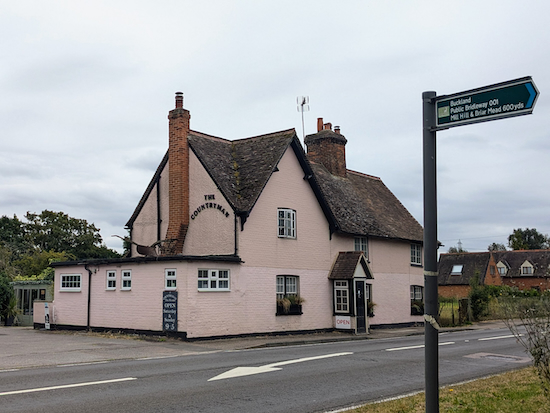
* The Countryman cafe will be on the right (location - https://w3w.co/thinnest.empire.melts). The cafe is open on Saturdays and Sundays from 9am to 5pm.
16: Cross the A10 then turn left. Head N for 35m crossing Chipping Bridge over the River Rib. Immediately after the bridge you will reach a bridleway on the right (location - https://w3w.co/promoting.pranced.stocked), see image below.
Turn right on a bridleway after crossing Chipping Bridge
Turn right on Buckland bridleway 11 then head SE for 40m until the bridleway goes off to the left (location - https://w3w.co/hugs.soulful.ruling), see image below.
The overgrown section can be avoided
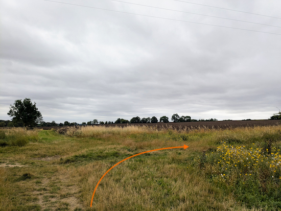
This short section was overgrown with brambles and nettles when we tested this route. We managed it in shorts using hiking poles to hack our way through. If you are unable to get through you could continue on the track (see orange arrow on the right on the image above) for 50m to rejoin Buckland bridleway 11 (location - https://w3w.co/spins.rave.irrigate).
17: Continue on Buckland bridleway 11 between two arable fields. This is a lovely bridleway with excellent views. Head ENE for 830m until you reach a junction on the edge of woodland (location - https://w3w.co/shelf.employ.loopholes), see image below.
Keep right still on Buckland bridleway 11
18: Keep right then continue heading ENE then SE, still on Buckland bridleway 11. Continue until you reach the end of the woodland (location - https://w3w.co/cloud.unspoiled.sagging), see image below.
Go through a gap in the hedgerow
19: Go through a gap in the hedgerow, cross a wooden footbridge, now on Wyddial bridleway 4, then head SE across an arable field.
20: Turn right on Wyddial bridleway 3 then head SW for 150m until you reach a bridleway on the left (location - https://w3w.co/subtitle.suitcase.walls), see image below.
22: Turn right on Wyddial Road then head SW for 35m until you reach Moles Lane on the left (location - https://w3w.co/replying.envisage.miles), see image below. There is a bench on the small traffic island.
Turn left on Moles Lane
Turn left on Moles Lane then head SSE for 335m until the lane ends and becomes a bridleway (location - https://w3w.co/slam.pronouns.bulb), see image below.
Head SSE on Wyddial bridleway 9
Continue heading SSE, now on Wyddial bridleway 9, for 100m until you reach a junction (location - https://w3w.co/idealist.cover.navy), see image below.
24: Turn right on Buntingford bridleway 4 then head ESE. Continue for 665m until you reach a junction (location - https://w3w.co/gossiping.neat.mirror), see image below.
Continue heading ESE, still on Buntingford bridleway 4
25: Follow Buntingford bridleway 4 as it bends right then heads SW for 315m, with hedgerow on the left and fields on the right, to a footpath junction (location - https://w3w.co/entrust.ground.according), see image below.
Head SW now on Buntingford bridleway 6
26: Keep heading SW now on Buntingford bridleway 6 for 115m, with hedgerow on the left and field on the right. Continue to a footpath junction (location - https://w3w.co/width.custard.bottle), see image below.
Continue heading SW, now on Buntingford footpath 34
Continue heading SW, now on Buntingford footpath 34, with hedgerow on the left and fields on the right, for 315m to a junction (location - https://w3w.co/hopes.regarding.learns), see image below.
28: Turn left on The Causeway then head in a westerly direction for 645m until you reach a ford and then a bridge over the River Rib (location - https://w3w.co/rainwater.tasters.grounded), see images below.
On 26 Aug 2024 the path near point 16 had been completely strimmed back and was clear. The Council seem to have acted promptly. We're enjoying the walk. Cheers Steve.
Fantastic walk, completed today 22/3/25. No problems with directions, but the large field between 9-10 has been smoothly ploughed, so you just need to keep an eye on your App, as there’s no physical marker for where you need to head. Brilliant walk. Lots of places for food and drink in Buntingford, and if it’s the weekend, the Chequers Tea rooms at Chipping is highly recommended Thanks David.
Comments and feedback If you try any of the walks on this site, please let us know what you thought of them by adding a comment here or on our members-only Facebook group. Comments here are checked before they are published. Comments on the Facebook group go live immediately.






On 26 Aug 2024 the path near point 16 had been completely strimmed back and was clear. The Council seem to have acted promptly. We're enjoying the walk. Cheers Steve.
ReplyDeleteHi Steve, thanks for the update. Good to know.
DeleteFantastic walk, completed today 22/3/25. No problems with directions, but the large field between 9-10 has been smoothly ploughed, so you just need to keep an eye on your App, as there’s no physical marker for where you need to head.
ReplyDeleteBrilliant walk. Lots of places for food and drink in Buntingford, and if it’s the weekend, the Chequers Tea rooms at Chipping is highly recommended Thanks David.
Wonderful, glad you enjoyed it Andrew, and thanks for the tearoom tip. David
DeleteAnother great walk with clear instructions. Endorse a previous comment recommending the tearoom in Chipping, a great discovery. Thanks Dave & Ellie
ReplyDeleteHi Carolyn, thanks for the feedback and update on the cafe.
Delete