6.1 miles (9.8 km) with 138m of total ascent
 |
| Much Hadham bridleway 5 between points 4 & 5 |
This is a lovely walk that follows footpaths, bridleways and byways on either side of the
River Ash between
Much Hadham and
Hadham Ford. It involves a fair amount of up and down, but it's worth it for the great views along the way.
There are several signs along the way asking dog owners to keep their pets on a lead, although we didn't come across any livestock when we did the walk. The route goes across a golf course on public rights of way, but crosses one fairway only.
Getting there
There are bus stops close to the start of the walk which are served by the numbers 35 and 35C buses. You can check bus times at
Intalink.
Fly through preview of walk
If you want to check what sort of landscape you will be crossing before you set off on this walk you can view a short 3D video of the route below. It's created using the free version of
Relive.
Directions
 |
Map for Walk 201: Much Hadham North Loop
Click on the map for larger version
Created on Map Hub by Hertfordshire Walker
Elements © Thunderforest © OpenStreetMap contributors
There is an interactive map below these directions |
Those with GPS devices can download
GPX or
KML files for this walk. We've added
What3Words location references for those who use that system. If you print these walks you might want to use the green
PrintFriendly icon at the bottom of these directions to delete elements such as photographs.
 |
| The Bull on High Street, Much Hadham |
1: With your back to
The Bull on High Street, Much Hadham (location -
https://w3w.co/cost.thus.probe), turn left then walk N along High Street for 190m until you reach a bridleway on the left (location -
https://w3w.co/comb.apples.known), see image below. There are some cute cottages along this stretch.
 |
| Turn left on Much Hadham bridleway 7 |
2: Turn left on Much Hadham
bridleway 7 then head W for 220m until you reach a junction, with a path going off to the right (location -
https://w3w.co/storms.moon.loads), see image below.
 |
| Ignore the path on the right and keep heading W |
Ignore the path on the right (it's not a public right of way) and keep heading W on Much Hadham bridleway 7 for a further 170m until you reach a
footpath on the right (location -
https://w3w.co/shout.fame.grand), see image below.
 |
| Turn right on Much Hadham footpath 6 |
3: Turn right on Much Hadham footpath 6 then follow it N for 65m across a field until you reach a gap in the hedgerow (location -
https://w3w.co/waters.skin.cars), see image below.
 |
| Cross the field then turn left before the hedgerow |
One across the field don't go through the gap but, instead, turn left before the hedgerow then head WNW for 175m with the hedgerow on your right and field on the left until you come to a gap in the hedgerow leading to a footbridge (location -
https://w3w.co/sunset.having.during), see image below.
 |
| Go through the gap, cross the footbridge, then turn right |
Go through the gap, cross the footbridge, then turn right and head N for 30m at which point Much Hadham footpath 6 bends left then heads WNW for 175m, with the hedgerow on the right and field on the left, until the footpath turns right into the hedgerow (location -
https://w3w.co/opens.tidy.family), see image below.
 |
| Much Hadham footpath 6 cuts through the hedgerow |
Follow Much Hadham footpath 6 through the hedgerow then head NW for 170m across a field, see image below.
 |
| Much Hadham footpath 6 heading NW across a field |
When you reach the other side of the field you will come to a gate (location -
https://w3w.co/crisp.blows.ties), see image below.
 |
| Go through the gate then keep right |
Go through the gate then keep right at a junction (location -
https://w3w.co/powder.pack.lock), see image below.
 |
| Go through the gate then keep right at a junction |
Keeping the house on the left, follow the footpath as it heads NW across a lawn for 120m to reach New Barns Lane (location -
https://w3w.co/launch.scouts.tribal), see image below.
 |
| Follow the footpath as it heads NW across a lawn |
This section of Much Hadham footpath 6 is not well marked after the gate so I have added an orange line to a satellite image of the area below to help you find the right direction.
 |
| Much Hadham footpath 6 as it reaches New Barns Lane |
4: Turn left on New Barns Lane then head W for 60m until you reach a junction (location -
https://w3w.co/neck.skin.falls), see image below.
 |
| Much Hadham bridleway 5 heading W |
New Barns Lane then becomes Much Hadham bridleway 5 then heads W then NW for 740m until it reaches a gap in the hedgerow leading to a junction (location -
https://w3w.co/space.unique.line), see images below.
 |
| Go through the gap on Much Hadham bridleway 5 to reach a junction |
 |
| Turn right then head NE on Standon footpath 82 |
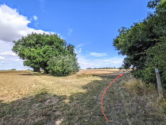
5: Once through the hedgerow, turn right at the junction then head NE on Standon footpath 82 with the hedgerow on the right and field on the left and continue for 540m until you reach a footpath joining from the left (location -
https://w3w.co/robot.regard.mercy). Ignore this path and continue heading NE through a gap in the hedgerow, still on Standon footpath 82. There is a handily placed bench on the right at this point. Continue on Standon footpath 82 for 530m until you reach Bromley Lane (location -
https://w3w.co/nods.stroke.knots).
6: Turn left on Bromley Lane then head N for 125m until you reach a footpath sign on the right (location -
https://w3w.co/pools.robots.safe), see image below.
 |
| Turn right on Standon footpath 76 |
Turn right on Standon footpath 76 then head NE and downhill for 310m to a footpath junction (location -
https://w3w.co/cats.poker.crush) just before you reach a vineyard, see image below.
 |
| Turn right on Much Hadham footpath 2 |
7: Turn right on Much Hadham footpath 2 then head SE with hedgerow and woodland on your left for 490m until you reach a footpath on the left just after the woodland ends (location -
https://w3w.co/neat.rarely.cross), see image below.
 |
| Turn left on Little Hadham footpath 5 |
8: Turn left on Little Hadham footpath 5 then cross a footbridge. Once on the other side you are entering the golf course belonging to
Ash Valley Golf Club, see image below.
* I have drawn a line on a satellite image just before point 10 below showing the route of the public right of way across the golf course for those who want to check.
 |
| Follow Little Hadham footpath 5 NNE across a fairway |
The public right of way, Little Hadham footpath 5, heads NNE across a fairway, see arrow on image above taken immediately after crossing the footbridge (location -
https://w3w.co/rubble.slang.galaxy), and the image below taken 70m NNE from the footbridge as you reach a group of trees where the path crosses the fairway (location -
https://w3w.co/burn.basket.admit).
 |
| Little Hadham footpath 5 NNE crossing the fairway |
Once across the fairway you will reach a footpath marker post (location -
https://w3w.co/cool.lions.stones). Continue heading NNE keeping a green on the left and a tee on the right until you reach a track (location -
https://w3w.co/money.stored.liner) where the path bends slightly to the right then heads NE for 60m until it reaches a footpath in the hedgerow on the left (location -
https://w3w.co/fumes.behave.phones), see image below.
 |
| Turn left as Little Hadham footpath 5 goes through the hedgerow |
Turn left through the hedgerow then head NNE, still on Little Hadham footpath 5, for 90m with a house on the left then a tennis court on the right until you reach a farm track (location -
https://w3w.co/splash.chained.rally). Cross the farm track then take a gate between the farm buildings (location -
https://w3w.co/flows.voted.expect), see image below.
 |
| Go through the gate on Little Hadham footpath 7 |
9: Little Hadham footpath 7 now goes between farm buildings. Look to your left when you pass one of the buildings and you will see a beamed barn with a green wooden horse-drawn caravan. According to Steve, a regular user of our walks who
posted a comment at the foot of these directions,
"the barn was made from the upturned hull of a wooden ship. There is a date 1830 on a beam", see image below.
 |
| The beamed barn, apparently made from the upturned hull of a wooden ship |
Continue on Little Hadham footpath 7 for 90m heading NE to a junction (location -
https://w3w.co/vegans.clocks.modifies), see image below.
 |
| Head NE with the hedgerow on the left and field on right |
Head NE for 170m with the hedgerow on the left and field on right until the path bends left then heads N and downhill to a dip and a gap in the hedgerow by a stream (location -
https://w3w.co/self.slant.stint), see image below.
 |
| Cross the stream on Little Hadham footpath 7 then turn right |
Cross the stream on Little Hadham footpath 7. Turn right after the tree (see image above) then head E and SE for 180m with the stream on your right and the golf course on the left until the footpath crosses the stream (location -
https://w3w.co/topical.rely.basics), see image below.
 |
| Cross the stream then head SE and E |
Cross the stream then turn left and head SE and E for 500m with the stream on your left and continue until you reach New Road (location -
https://w3w.co/shave.lines.lock), see image below.
 |
| Little Hadham footpath 7 approaching New Road |
I have drawn an orange line on the satellite image below showing the route of the public right of way across the golf course.
 |
| Little Hadham footpath 7 crossing the golf course |
10: Cross New Road then continue heading E, now on Little Hadham bridleway 13, for 185m before the path turns left just before the River Ash (location -
https://w3w.co/winter.taxi.limp), see image below.
 |
| Turn left before the footbridge, still on Little Hadham bridleway 13 |
11: Head NE, still on Little Hadham bridleway 13, with the River Ash on your right and continue until you reach a road called The Ford (location -
https://w3w.co/basher.stability.fevered). Turn left on The Ford then, when you reach the
Nag's Head on the left (location -
https://w3w.co/ages.funky.sooner), cross the road to reach a footbridge crossing Hadham Ford (location -
https://w3w.co/collision.boat.sparkle), see images below.
 |
| The Nag's Head |
 |
| Cross the footbridge on Little Hadham footpath 44 |
12: Cross the footbridge over the River Ash on Little Hadham footpath 44 then head E ignoring two footpaths on the right and continuing uphill for 540m until you reach a footpath on the right which crosses a field (location -
https://w3w.co/resonated.rival.hence), see image below.
 |
| Turn sharp right at the junction then head SW across a field |
13: Turn sharp right at the junction then head SW on Little Hadham footpath 49 crossing a field for 230m until you reach woodland and a junction (location -
https://w3w.co/opera.swan.hurry), see image below.
 |
| Little Hadham footpath 49 crossing the field |
When you reach the hedgerow go through a gap, ignoring a footpath on your right, then turn right on a byway called Hoecroft Lane, which is also Little Hadham BOAT 45 (
byway open to all traffic). There is a bench at this spot which we found particularly welcome (location -
https://w3w.co/formal.grew.icons).
Head SW on Little Hadham BOAT for 260m until you reach a lane called Acremore Street.
14: Turn right on Acremore Street then head W for 80m until you reach a bridleway on the left (location -
https://w3w.co/beans.before.looks), see image below.
 |
| Turn left on Little Hadham bridleway 16 |
Turn left on Little Hadham bridleway 16 then head SSW for 1.3km. Continue along Little Hadham bridleway 16 until you reach a gap in the hedgerow and a junction (location -
https://w3w.co/shell.heap.sheet), see image below.
 |
| Head S at the junction, now on Much Hadham bridleway 16 |
15: Go through the gap, ignore the bridleway on the right, and keep heading S with the hedgerow on the left and field on the right. (Soon after the junction you should find a bench on your left). Continue heading S, now on Much Hadham bridleway 16, for 330m until you reach a bridleway junction (location -
https://w3w.co/finest.being.villa), see image below.
 |
| Keep right at the junction, still on Much Hadham bridleway 16 |
Keep right at the junction, still on Much Hadham bridleway 16, then head SW for 210m until you reach a junction where you keep left, still on Much Hadham bridleway 16, then head S for 30m until you reach a road called Winding Hill (location -
https://w3w.co/arena.full.crops). Cross Winding Hill then take the footpath on the other side, see image below.
 |
| Much Hadham footpath 18 off Winding Hill |
16: After crossing Winding Hill take Much Hadham footpath 18 then head SSE for 205m, passing a tennis court on the left and continuing to a junction (location -
https://w3w.co/nights.shadow.looked), see image below.
 |
| Keep left at the junction on Much Hadham footpath 19 |
17: Keep left at the junction, now on Much Hadham footpath 19, then head SSE and uphill for 100m to a junction (location -
https://w3w.co/begun.void.repair). Ignore the footpath on your right which goes downhill and instead turn right on a lane, which is also Much Hadham footpath 21, see image below.
 |
| Turn right on Much Hadham footpath 21 |
18: Head W on Much Hadham footpath 21 for 200m until you reach a footpath on the right (location -
https://w3w.co/cook.feel.soup), see image below.
 |
| Turn right at the gate, still on Much Hadham footpath 21 |
19: Turn right at the gate, still on Much Hadham footpath 21, then head downhill and WSW for 200m until you reach a footbridge leading to Church Lane (location -
https://w3w.co/blocks.glaze.deny), see image below.
 |
| The footbridge leading to Church Lane |
20: Turn left on Church Lane then head S for 55m to a bend (location -
https://w3w.co/staple.dawn.over). Follow Church Lane to the right at the bend then continue heading W along Church Lane for 130m back to the starting point.
Interactive map


Another excellent walk - thank you for sharing. Clear instructions and helpfully annotated photographs.
ReplyDeleteWe very much enjoyed the extensive views and big skies. The blackberries between points 14 and 15 were the best we have found this year. There is an interesting old "shepherd's hut" in the farm barn at point 9 - we were told it had been in the woods near an old quarry where an old lady had lived in it.
However, disappointingly the Nag's Head was closed (Friday lunchtime) when we did this walk. No sign of any opening times that we could see.
Yes, we really enjoyed this walk, too. And I took a picture of the shepherd's hut but didn't add it to the directions. It was in a lovely barn. I was more focused on the beams. You can see the picture here. https://photos.app.goo.gl/gxd57RmhES5rpjxu7
DeleteDave
We were told that the barn was made from the upturned hull of a wooden ship. There is a date 1830 on a beam
ReplyDeleteGreat research Steve, I have added that fact (and a photo of the barn) to the directions (above). Thanks for sharing that info.
DeleteDave
No worries Dave. Great walk. We tried it today. A bit wet but loads of blackberries to keep us going
ReplyDeleteA beautiful autumn walk today with excellent directions.The blackberries are still prolific. May thanks
ReplyDeleteYes, a lovely day for walking. The autumn colours are really nice just now. Glad you enjoyed it.
DeleteThank you. Yet another great walk. https://www.johnslabourblog.org/2023/05/hertfordshire-walker-much-hadam-north.html
ReplyDeleteHi John, glad you liked the walk. I enjoyed reading your write-up on your site. Sorry to hear you got a bit lost on the golf course, but glad the GPX files helped; they are so useful for sections of walks where signposts and landmarks are not that clear or easy to describe. Thanks for the feedback. David
DeleteI have just completed this walk. Such a lovely area with lots of wide open views. Shame the double gate at the farm was padlocked shut (#9) but fortunately my large dog could push past the overgrowth to the side. The GPS is great - today was my first time using it. My only concern is that I will become lazy about map reading!! Thank you again for such a brilliant website which I wish I had discovered years ago. I have done at least 6 of your walks over the past couple of months.
ReplyDeleteSo glad you enjoyed the walk. Do we need to report the blocked right of way to Herts County Council? Good the GPX helped. I use it alongside maps (on my phone). It's very useful in wooded areas where it's sometimes difficult to describe the twists and turns. If you haven't already done so, please consider of joining our members-only Facebook group where fellow walkers are posting about their walks and sharing photos taken along the way.
Deletehttps://www.facebook.com/groups/hertfordshirewalker
Did this one today David. Another really lovely loop . Point 13 with the sharp right turn was not possible as the field was full of crops and the path not yet reinstated . Easy fix to continue around the edge of the field which we did . All the best ..
ReplyDeleteThanks for the tip regarding point 13 Mick.
Delete