This is a good walk for anyone who can't manage ups and downs or climbing over stiles. It’s mainly on the flat and along wide tracks. Ideal for anyone pushing a buggy. You will be following bridleways through fields and footpaths through woodland. There are a couple of footbridges along the route, but few obstacles. The walk circles the largely defunct Hunsdon Airfield, used by the RAF between 1941 and 1945 under the name of RAF Hunsdon.
Video highlights
Below is a video of some of the highlights of this walk. It's been created by Gerry Gross, who has completed all 300 of the free walks on Hertfordshire Walker. We are grateful to Gerry for the time and effort he has put into recording - for the benefit of all - some of his favourite walks on the site.
To view the video in full screen click the expand arrows at the bottom right of the video screen. They are recorded in 4K but YouTube reduces the quality by default so you can change the video quality to 2160p (aka 4K) in settings once you play the video.
Those with GPS devices can download GPX or KML files for this walk. We've added What3Words location references for those who use that navigation system. If you print these walks you might want to use the green PrintFriendly icon at the bottom of these directions to delete elements you don't need.
Hunsdon footpath 17 going through the crop - point 1
1: Park in Hunsdon (location - https://w3w.co/equal.chose.proven) after checking for any parking restrictions. Head NE up Drury Lane for 260m until it becomes a track and you reach a fork (location - https://w3w.co/minus.libraries.acting). Take the left fork and follow Hunsdon footpath 17 NE for 660m, at first with the hedgerow on the left and the field on your right then across the crop heading for Black Hut Wood.
Turn right on Hunsdon footpath 21 Image courtesy Gerry Gross
3: Turn right on Hunsdon footpath 21 then head ENE for 740m with Marshland Wood on your left. At the end of the wood cross a field before reaching more woodland, this time Lawns Wood (location - https://w3w.co/putty.ports.head).
Take the right fork mentioned in point 4
4: At a junction where the track goes left, you take the right fork (location - https://w3w.co/tiny.owners.opera) and head SE through Lawns Wood on Eastwick & Gilston footpath 21 for 310m until you come to a footbridge leading to a field (location - https://w3w.co/stores.powers.state).
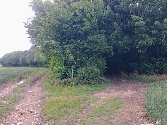
Eastwick & Gilston restricted byway 24 mentioned in point 5
5: Turn right on High Wych restricted byway 37 and head first SW and then S for 370m until you reach a crossing in the track. Continue S, now along Eastwick & Gilston restricted byway 24, for 1km until you reach Overhall Farm on the left (location - https://w3w.co/neon.scary.reason) and a T-junction beyond the farm buildings (location - https://w3w.co/twig.grace.begin).
6: Turn right on a lane and head W and SW for 630m to Home Wood.
Turn right on the lane, Eastwick & Gilston footpath 8
8: When you reach the wall, pictured above, turn right on the lane, which is also Eastwick & Gilston footpath 8. Walk past some houses and head W for 590m passing Eastwick Hall Farm on the right (location - https://w3w.co/booth.intervals.shell).
The footpath and bench mentioned in point 9
9: When you reach a footpath junction (with a bench on the left) where the track bends to the right (location - https://w3w.co/woes.means.loyal), you keep straight and head NW through the woodland on Hunsdon footpath 5 for 490m. The path veers right (location - https://w3w.co/attend.tuned.rests) and leaves the woodland, crosses a field, enters woodland via a footbridge (location - https://w3w.co/punk.shelf.detect) , and continue heading NW past a pond on the left (pictured at the top of the page) and continue to Acorn Street (location - https://w3w.co/fortunate.bucked.boost).
Hunsdon footpath 5 crossing the field mentioned in point 9
10: Turn right on Acorn Street and head N. Ignore the first path on the left and continue for 160m until you reach a byway on the left (location - https://w3w.co/kick.boom.sang).
Turn left on Hunsdon restricted byway 3A Image courtesy Gerry Gross
Turn right on High Street Image courtesy Gerry Gross
12: Turn right on High Street then head NNE for 70m looking out for a track on the left (location - https://w3w.co/tools.nation.raced). Take this track Hunsdon restricted byway 3 and head NW for 490m until you reach a footpath on your right (location - https://w3w.co/quit.chain.wiring).
Hunsdon footpath 6 mentioned in point 13
13: Turn right on Hunsdon footpath 6 and head NE for 500m with the hedge on your left and the field on your right. After 330m you cross Tanners Way (location - https://w3w.co/likes.jeeps.rooms) and continuing through a park to High Street (location - https://w3w.co/ages.storm.season).
Turn left on High Street Image courtesy Gerry Gross
14: Turn left on High Street then head NE for 200m back to Hunsdon village centre.
A brilliant walk in the gorgeous sunshine today but there is not a lot of shade on this pretty flat walk. Lovely and mud free right now, but you can tell in wetter conditions it will be very muddy in places! On the way round you get some wonderful distant views and this would be a great one for autumn as you do pass woodlands as well as walk through them. So I'll be back then!
Comments and feedback If you try any of the walks on this site, please let us know what you thought of them by adding a comment here or on our members-only Facebook group. Comments here are checked before they are published. Comments on the Facebook group go live immediately.




A brilliant walk in the gorgeous sunshine today but there is not a lot of shade on this pretty flat walk. Lovely and mud free right now, but you can tell in wetter conditions it will be very muddy in places! On the way round you get some wonderful distant views and this would be a great one for autumn as you do pass woodlands as well as walk through them. So I'll be back then!
ReplyDelete