6.5 miles (10.5 km) with 93m total ascent
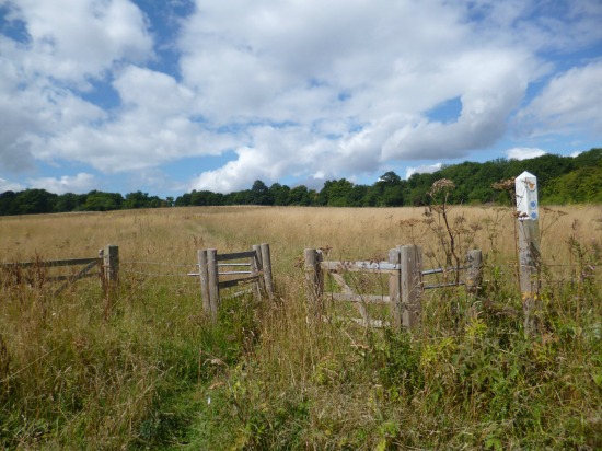 |
| North Mymms bridleway 90 at point 3 in the walk |
This circular walk starts from St Mary’s Church, North Mymms, and heads S through Cangsley Grove then over the Potwells Valley then down to the Colne Valley and via Colney Heath before looping back to North Mymms.
The route crosses several livestock fields and there are several signs asking dog owners to keep their pets on a lead.
There is a diversion between points 19 and 21 which, according to Hertfordshire County Council is in place up to 20 March 2025, details below.
 |
| Diversion notice in Roestock |
The map below shows the diversion in orange. The green line is the original route of this walk.
 |
| The orange line is the diversion mentioned above |
Getting there
There is a bus stop close to the start of the walk. The stop is called 'North Mymms Tollgate Road War Memorial'. It is served by bus numbers 200, 230, 305, 313, 355, and 356. You can check bus times at the
Intalink site.
Fly over the route before you set off
If you want to check what sort of landscape the long version of this walk covers before setting off you can view a short 3D video of the route below. It's created using the free version of
Relive.
Directions
 |
Map for Walk 31: North Mymms South-West Loop
Click on the map above for a larger version
Created on Map Hub by Hertfordshire Walker
Elements © Thunderforest © OpenStreetMap contributors
There is an interactive map at the end of these directions |
Those with GPS devices can download
GPX or
KML files for this walk. We've added
What3Words location references for those who use that system. If you print these walks you might want to use the green
PrintFriendly icon at the bottom of these directions to delete elements such as photographs.
1: Park along St Mary’s Church Road (location -
https://w3w.co/heavy.claims.hits), which is also North Mymms bridleway 2, then head SSW until the road forks (location -
https://w3w.co/take.remind.bunch), see image below.
 |
| Keep left at the fork then continue heading SSW |
Keep left at the fork then continue heading SSW for 470m until the road bends to the right (location -
https://w3w.co/cook.erase.onions), see image below.
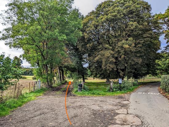 |
| Keep left at the fork on North Mymms bridleway 2 |
2: Keep left at the fork then head SSW along North Mymms bridleway 2 for 770m as it climbs the hill through Cangsley Grove. Continue until you reach a gate on the right with views across the Potwells Valley (location -
https://w3w.co/output.chips.navy), see image below.
 |
| Go through the gate then follow North Mymms bridleway 90 |
3: Go through the gate then follow North Mymms bridleway 90 SW for 215m with the woodland on the right and field on your left. This bridleway crosses a parish boundary (location -
https://w3w.co/dress.ends.beyond) and you will continue on Ridge bridleway 44 then head SW for 440m until you reach to a footpath on your right (location -
https://w3w.co/surely.robots.hurls), see image below.
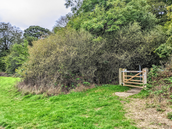 |
| Turn right on Ridge bridleway 10 |
4: Turn right on Ridge bridleway 10 then head SW for 850m until you reach a farm and a footpath on the right (location -
https://w3w.co/salsa.dunes.fields), see image below.
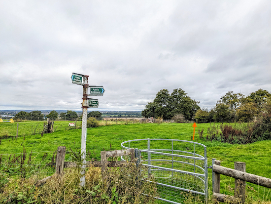 |
| Go through the gate then follow Ridge footpath 8 |
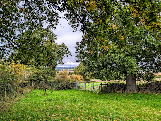
5: Go through the gate then follow Ridge footpath 8, which heads NW and downhill for 120m to a gate (location -
https://w3w.co/open.advice.rocks), see image below.
 |
| Go through the gate then head N |
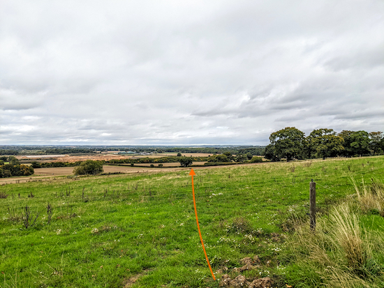
6: Go through the gate then head N and diagonally across a field, still on Ridge footpath 8, for 155m to a gate (location -
https://w3w.co/ready.lock.cheek), see orange line on the image below to judge the direction you need to walk to reach the gate.
 |
| Head N and diagonally across a field |
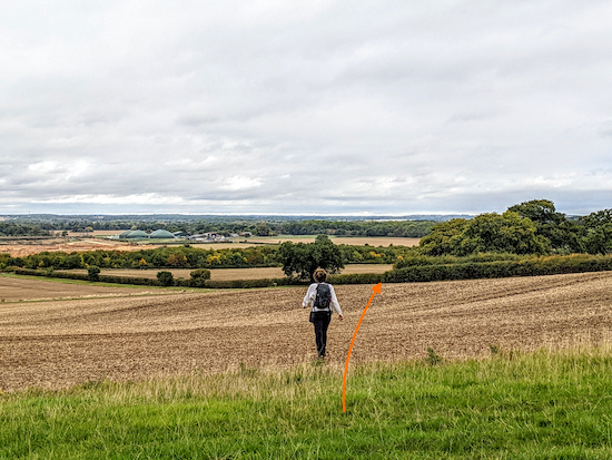
7: Once through the gate, continue heading N across a second field, still on Ridge footpath 8. The field had just been ploughed when we revisited this walk. See orange line on the image below for the direction you need to walk.
 |
| Head N across the field, still on Ridge footpath 8 |
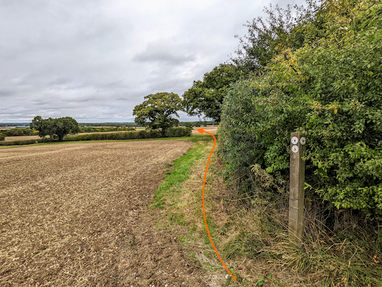
Continue heading N, still on Ridge footpath 8, for 180m, until you reach the corner of the field (location -
https://w3w.co/pipe.allow.grass), see image below.
 |
| At the corner of the field go through the gap then turn left |
8: When you reach the corner of the field (see orange arrow on the image above), go through the gap then turn left and head NNW, still on Ridge footpath 8, with the hedgerow on your left and the field on your right. Continue for 130m until you reach a signpost on the right (location -
https://w3w.co/spot.sketch.plus), see image below.
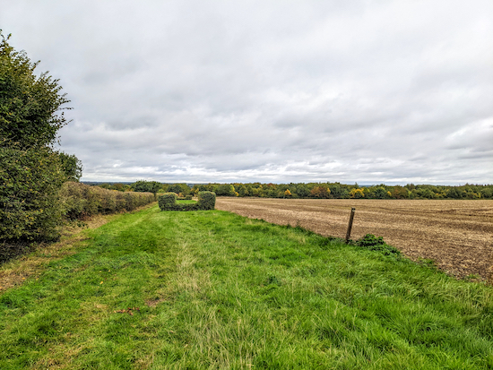 |
| The permissive path follows the hedgerow NW |
9: At this point Ridge footpath 8 crosses a field, but there is an alternative permissive path which continues to head NW with the hedgerow on the left and the field on the right for 185m until it meets a track (location -
https://w3w.co/notice.fans.forgot). We took this route because the field had just been ploughed and Ridge footpath 8 had not been reinstated.
10: Turn right when you meet the track then head ENE for 300m along a
permissive path until the path bends left (location -
https://w3w.co/vanish.work.timing) then heads NW for 350m to a junction just beyond an industrial area (location -
https://w3w.co/open.tiny.librarian) where you turn right, see image below.
 |
| Head NNE then NNW, still on Ridge footpath 8 |
11: Continue on Ridge footpath 8 heading NNE then NNW for 730m until you reach Coursers Farm (location -
https://w3w.co/builds.meal.adding). Follow Ridge footpath 8 through the farmyard for 270m until you reach a stile (location -
https://w3w.co/hello.broad.shorts), see image below.
 |
| Cross the stile and the next field to reach Coursers Road |
Cross the stile and the next field to reach Coursers Road (location -
https://w3w.co/trades.strong.varieties).
12: Cross Coursers Road then turn right on Ridge bridleway 32 and follow it ENE for 260m until the bridleway bends left (location -
https://w3w.co/dices.fuel.price), see image below.
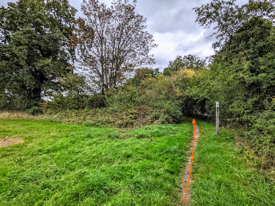 |
| Go through the gap and continue heading N |
13: Go through the gap then continue heading N with the hedgerow on the right and a field on the left for 290m until you reach a gate on the left (location -
https://w3w.co/buns.smooth.curvy), see image below.
 |
| Go through the gate then follow the path WNW |
14: Go through the gate then follow the path WNW then NW for 250m until you reach a track (location -
https://w3w.co/every.useful.adding), see image below.
 |
| Turn right on the track then head NNE |
15: Turn right on the track then head NNE for 230m until you reach Coursers Road (location -
https://w3w.co/ruins.guitar.brand), see image below.
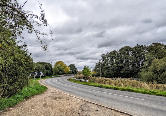 |
| Turn left on Coursers Road then head NE |
16: Turn left on Coursers Road then head NE for 160m crossing the River Colne and continuing until you reach the end of the crash barrier on the left (location -
https://w3w.co/rooms.curiosity.survey). Turn left after the crash barrier then follow the path down to the common, see image below.
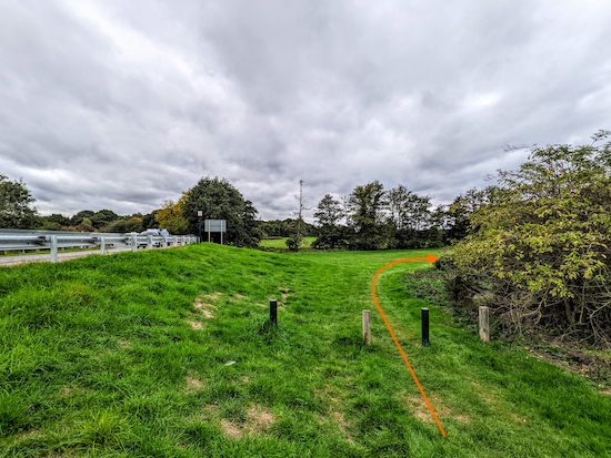 |
| Keep right then follow the path round to the right |
Keep right then follow the path round to the right to reach High Street Colney Heath (location -
https://w3w.co/cult.laser.gates).
* There is a pub, The Crooked Billet, in Colney Heath as well as some shops selling refreshments. The Crooked Billet is 440m on the left along High Street.
17: Cross High Street then take Colney Heath footpath 24 and head NE for 505m until you reach a track (location -
https://w3w.co/gift.thanks.evenly).
18: Turn right on the track, Colney Heath restricted byway 51, then follow it S then SE for 170m until you reach Roestock Lane (location -
https://w3w.co/under.leaps.bless), see image below.
 |
| Cross Roestock Lane then take Colney Heath footpath 23 |
19: Cross Roestock Lane then head SE on Colney Heath footpath 23 for 170m until you reach a junction (location -
https://w3w.co/settle.tunnel.become), see image below.
 |
| Turn left at the junction |
20: Turn left at the junction on Colney Heath footpath 48 then head E for 260m until you reach Bullens Green Lane (location -
https://w3w.co/love.drift.onion).
21: Turn right on Bullens Green Lane and follow it SSW then S for 560m until you reach Tollgate Road (location -
https://w3w.co/summer.shady.larger).
22: Turn left and head SSE on Tollgate Road for 50m before taking the footpath on your left just after the farm (location -
https://w3w.co/clever.runner.quit). This is North Mymms footpath 41. Here you go diagonally to your left heading ESE for 260m towards the energy pylon in the middle of the field. Go under the pylon and continue now heading ENE for 350m towards the A1(M) crossing a farm track on the way.
23: When you reach the A1(M) turn right (location -
https://w3w.co/brave.hints.edits) and head S until you reach the farm track again. Cross the track to the right of the bridge over the A1(M) and take the stairs on the other side of the track (location -
https://w3w.co/scam.puff.shut). Do not cross the A1(M) bridge but stay on the W side heading SE with the A1(M) on your left and the field on your right for 55m until you reach a footpath on your right (location -
https://w3w.co/complains.cards.plays).
24: Turn right on the North Mymms footpath 55 then follow it WSW for 550m following a line of trees until you reach Tollgate Road (location -
https://w3w.co/town.upper.shut).
25: Turn left inside the field and then follow a permissive path SE for 210m until you reach a gate on the right (location -
https://w3w.co/known.gifted.lined). see image below
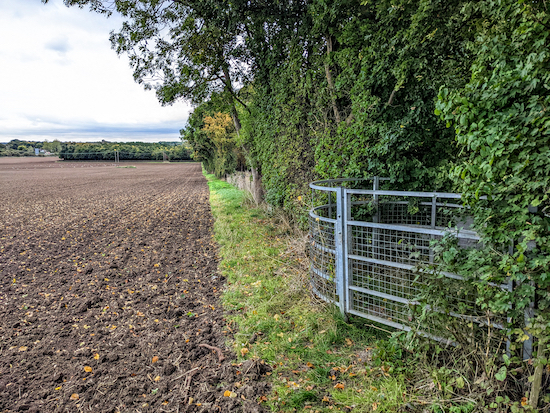 |
| Go through the gate, cross Tollgate Road |
26: Go through the gate, cross Tollgate Road, then go through a gate on the other side, then follow North Mymms footpath 29 SE for 380m until you reach a gate leading to a footbridge (location -
https://w3w.co/froth.dive.large), see image below.
 |
| Cross the footbridge then follow North Mymms footpath 29 SE |
27: Cross the footbridge then follow North Mymms footpath 29 SE for 280m crossing a track along the way (location -
https://w3w.co/dark.editor.waters) and continuing until you reach St Mary's Church churchyard (location -
https://w3w.co/complains.hedge.tulip).
28: Continue through the churchyard back to St Mary's Church Road and the starting point.
* There is a pub, The Woodman Inn (location - https://w3w.co/toast.loving.soil), a 790m detour from the start and finish point.
Interactive map


I did this walk yesterday which sounded pleasant. Sadly - new buildings, overgrown gates and paths across fields not reinstated resulting in clomping across ploughed fields rather spoiled the enjoyment. Thank you for the gpx file which talks to my OSMaps app. Without that I would have struggled. I did take a few photos of the better bits 😊
ReplyDeleteSo sorry you had a bad experience. We have not done that walk for several years. Sad to hear parts of the rights of way are overgrown or have not been reinstated. Would you have time to report these sections of the walk to Hertfordshire County Council? The rights of way team has an online form where you can let them know where public rights of way need attention. They are usually quick to respond.
Deletehttps://www.hertfordshire.gov.uk/services/highways-roads-and-pavements/report-a-problem/report-a-highway-fault/public-rights-of-way/public-rights-of-way.aspx
David
We revisited this walk today, added loads of pictures, rerouted it slightly, and have contacted Hertfordshire County Council and a landowner about the status of a footpath. Thanks for raising these issues.
DeleteDavid
Excellent, thank you- it definitely has potential to be a pleasant walk 👍
DeleteThank you.
DeleteThanks for a great walk as ever. No issues with ploughed fields but lots of wading through temporary swamps (my wife's choice of boots was superior to mine of shoes). At point 9 we were able to follow the correct path. At 13 it might be clearer to say that the hedgerow has the road at the other side of it. Unless we missed something, I think the footpath at 20 is closed because of the enormous building site, so we made our way through the village and then had a longer walk along Tollgate.
ReplyDeleteThanks for the feedback. Another walker has posted a similar comment about the building work and the closed footpath which also affects walk 42. We will revisit both when we can and see if we can find a detour. Regarding point 13, I think that if people keep the hedgerow on the right and follow the footpath they should be fine. I mention hedgerows a lot to try to give walkers help in finding the right direction. If you haven't already done so please consider joining our friendly Hertfordshire Walker Facebook group where fellow walkers are sharing tips and photos from their walks. Thanks again for the feedback. David
ReplyDeletehttps://www.facebook.com/groups/hertfordshirewalker
Hi David, I did this walk today and really enjoyed it, thank you. Lots of sweeping views of the hills and fields which I always love. The first field at Point 6 is grass/wild flowers at the moment, just like in your photo, and it was very uneven under foot. The grass is deceptive and hides some quite big drops so I urge caution as you walk through that bit. The ploughed field just after it was a breeze in comparison!
ReplyDeleteThe footpath at point 10 was almost hidden by the bushes but thankfully the sign is very clear so it was easy enough to fine it. The industrial area that you also mention in point 10 is now almost blocking the footpath where you need to come out to find the gate. I have reported it to the Council and sent them some photos (will add to my report on FB so you can see too). You can get through but it's not ideal. At point 15, I went via the heath instead of going along Coursers Road. It does mean crossing the River Colne via stepping stones rather than the bridge but I like that! The closed footpath due to the building work that previous people have commented on is still there. I think the sign you have at the top refers to that but it's not at points 6-8 like it says - it's more like point 20. I found it easy enough to divert by going through the gate on your photo (instead of left) and through the playground, then round a small residential area onto Fellowes Lane, then rejoining by turning right on Bullen's Green Lane. Hope this helps for others when doing this during the building work. Thanks for another good walk.
Thanks Emma, I will take a look. Really good of you to share such detailed feedback.
Delete