3.5 miles (5.6 km) with 88m of total ascent
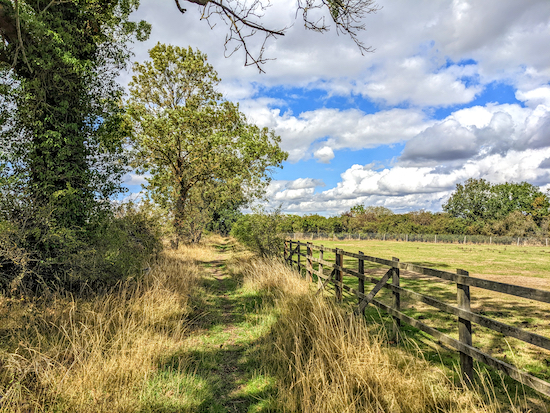 |
| Hertford footpath 107 between points 12 & 13 |
This is a lovely walk along a winding path that runs along the western edge of
Waterford Heath Nature Reserve. It's worth pausing as you walk through the heath to read the information boards along the way. The route then follows the River Beane before circling parkland on a public right of way.
The starting point is a car park off Vicarage Lane which is two miles N of Hertford North station by road. At the time we tested this walk in August 2022 the car park was free of charge.
Getting there
There are bus stops at various points in the walk including point 6 (location -
https://w3w.co/among.shave.magma), 17 (location -
https://w3w.co/soap.wakes.adopt), and 18 (location -
https://w3w.co/birds.vibrates.spots) in the walk which are served by the number 390 bus. You can check bus times at
Intalink.
There are several signs along the way asking dog owners to keep their pets on a lead. At one point the route crosses a livestock field where sheep were grazing when we walked the route.
We have another walk in this area. It's
Walk 84: Waterford Heath Loop.
Fly through preview of walk
If you want to check what sort of landscape you will be crossing before you set off on this walk you can view a short 3D video of the route below. It's created using the free version of
Relive.
Directions
 |
Map for Walk 203: Waterford South-West Loop
Click on the map above for a larger version
Created on Map Hub by Hertfordshire Walker
Elements © Thunderforest © OpenStreetMap contributors
There is an interactive map below these directions |
Those with GPS devices can download
GPX or
KML files for this walk. We've added
What3Words location references for those who use that system. If you print these walks you might want to use the green
PrintFriendly icon at the bottom of these directions to delete elements such as photographs.
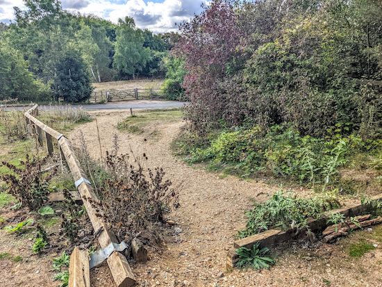 |
| Leave the car park then cross Vicarage Lane |
1: From the car park off Vicarage Lane (location -
https://w3w.co/elbow.skirt.reward) cross the road to reach a gate leading to
Waterford Heath, a
Herts & Middlesex Wildlife Trust nature reserve (location -
https://w3w.co/pinch.hills.sums), see images above and below.
 |
| Go through the gate leading to Waterford Heath |
There are various signs on the gate indicating what is and is not allowed to take place on the heath. There are also some rules for dog owners.
Waterford Heath used to be a sand and gravel quarry until the early 1990s when it was transformed into a "community nature park". It is mainly grassland with areas of scrub, wood plantation and semi-natural woodland.
Wikipedia.
Our walk follows a route along the western edge of the reserve passing information boards describing the landscape along the way.
As you go through the gate look to your left to see the 'cliffs' (location -
https://w3w.co/lands.winner.soup). If you wander over you will see a sign which reads:
"Several lengths of sandy cliff remain from the quarrying activities. These provide a rare opportunity to study underlying geology. Several large blocks of gravel mother-stone jut out from the cliff. The cliffs are mainly bare with scattered scrub of Willow and Birch clinging to the eroding sand and gravel faces. The bare soils are quickly warmed by the sun and therefore provide a valuable habitat for insects, especially burrowing bees and wasps."
 |
| The information sign at the cliffs on Waterford Heath |
From the gate, head 110m SE until you reach a rock outcrop on the right (location -
https://w3w.co/bowls.flap.fruit) where
Ice Age fossils have been found, see image below.
 |
| The rocks on Waterford Heath |
According to an information board in front of the rock formation:
"The rock outcrop in the foreground is a conglomerate of gravel, cemented by calcium carbonate. Too tough to be quarried, it has survived the former mineral workings. Also typical of disused sand and gravel workings in East Hertfordshire are fossils brought from further north by the Ice Age glacier."
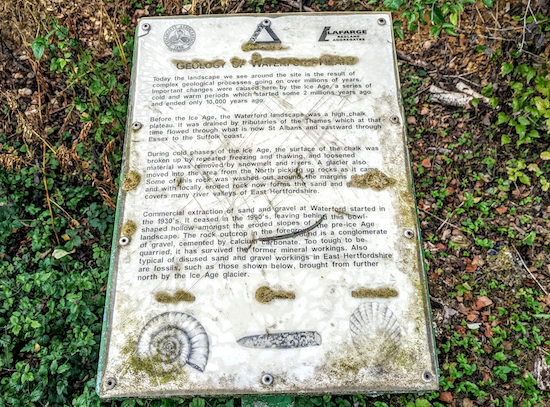 |
The information sign at the rocks on Waterford Heath
Click here or on the image above for a larger version |
From the rocks continue heading SE for 70m, with the rocks on the right, until the path bends to the right by a bench (location -
https://w3w.co/facing.buck.tent). This spot has great views over the southern section of the heath, see image below.
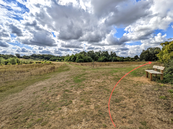 |
| Follow the path as it bends to the right after the bench |
2: From the bench the path bends right then heads SW for 110m to a metal gate (location -
https://w3w.co/chief.cover.zone). Go through the gate, cross a path, then go through a second metal gate (location -
https://w3w.co/badge.emerge.rots), see image below.
Immediately after going through the gate you will come to another information board on the left. Follow this lovely path S, see image below.
 |
| The track along the western edge of the heath |
Continue weaving S along this path for 350m until you reach silt beds on the left. According to the information board the shallow lagoons have become a habitat for common orchids and bee orchids which can be seen in June (location -
https://w3w.co/jets.river.zone), see image below.
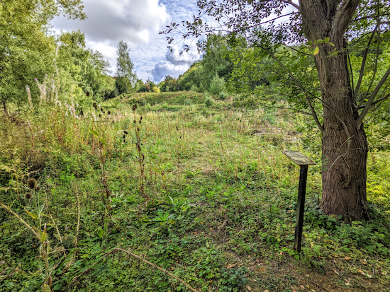 |
| The silt beds have created shallow lagoons |
3: Continue heading S for another 70m until you come to a bend (location -
https://w3w.co/bugs.drums.fuzzy), see image below. This is one of two points where there is a shortcut on the right, but the path is steep and it's better to keep left.
 |
| Keep left at the first junction |
Turn left at the junction then head NE for 40m to a second junction, also with a shortcut on the right (location -
https://w3w.co/resist.earth.backup). Again, keep left at this junction then continue uphill, see image below.
 |
| Keep left at the second junction then walk uphill |
Head NE for 80m passing a bench on the left and then reaching a junction at the top of the hill (location -
https://w3w.co/drum.canny.glee) where you keep right, see image below.
 |
| Keep right at the third junction at the top of the hill |
When you reach the junction at the top of the hill head E for 30m looking for a path on the right (location -
https://w3w.co/shots.farm.deep), see image below.
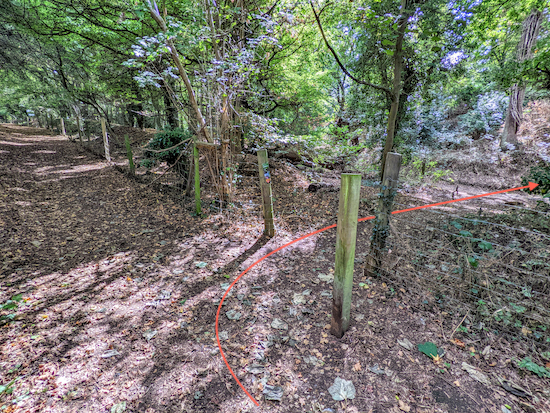 |
| Turn right at the junction then head SSW |
4: Turn right at the junction then head SSW for 20m until you reach a T-junction with Hertford
footpath 24 (location -
https://w3w.co/groom.apron.push), see image below.
 |
| Turn right on Hertford footpath 24 then head SSW |
Turn right on Hertford footpath 24 then head SSW for 55m until you reach a junction (location -
https://w3w.co/crest.scuba.hogs), see image below.
 |
| Keep right at the junction, still on Hertford footpath 24 |
Keep right at the junction, still on Hertford footpath 24 then head WSW for 115m until you reach a footbridge (location -
https://w3w.co/stay.putty.crust), see image below.
 |
| Cross the footbridge then continue heading WSW to a tunnel |
Cross the footbridge then continue heading WSW for 80m, still on Hertford footpath 24, to a tunnel under the railway (location -
https://w3w.co/beans.table.guess), see image below.
 |
| Go through the tunnel under the railway |
Go through the tunnel under the railway then continue on Hertford footpath 24 now heading W for 95m until you reach the banks of the River Beane (location -
https://w3w.co/hungry.ants.scuba).
There is a shortcut on the left immediately after you emerge from the tunnel, but if you take this you will miss a lovely part of the River Beane where
weeping willow almost touches the clear water, see image below.
 |
| Turn left when you reach the River Beane on Hertford footpath 26 |
5: Turn left when you reach the River Beane on Hertford footpath 26 then head S for 140m until the river bends right and the path bends with it (location -
https://w3w.co/water.foam.wiping). Continue on Hertford footpath 26, now heading SW with the river on the right for 170m until you reach a gate at the SW exit of Waterford Heath (location -
https://w3w.co/begins.ticket.branch), see image below.
 |
| The gate at the SW exit of Waterford Heath |
Continue heading SW, still on Hertford footpath 26, with the river on the right (see image below), until you reach North Road, the A119 (location -
https://w3w.co/award.hopes.finds).
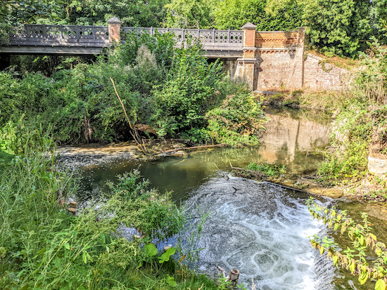 |
| Continue with the River Beane on the right until you reach North Road |
Turn left on North Road, the A119, then head S along the pedestrian pavement for 240m until you reach a footpath across the road (location -
https://w3w.co/teach.wooden.faster), see image below.
 |
| Cross the A119 with care to reach Hertford footpath 107 |
Cross the A119 with care to reach Hertford footpath 107. This is a particularly lovely footpath with shaded woodland stretches at first, then open parkland, followed by stretches of hedgerow walking.
Follow Hertford footpath 107 N for 190m until you reach a private drive (location -
https://w3w.co/rates.tall.exact). At this point, the public right of way turns left along this drive and crosses a bridge over the River Beane (location -
https://w3w.co/member.linked.twice), see image below.
 |
Hertford footpath 107 crossing the River Beane
|
8: Cross the River Beane then head NW for 140m until you reach a junction (location -
https://w3w.co/juices.tens.chase). Keep left at the junction, still on Hertford footpath 107, then head W for 70m to another junction (location -
https://w3w.co/truly.fend.transmitted), see image below.
 |
| Keep left at the junction then take the footpath on the left |
Keep left at the junction then take the footpath on the left, still Hertford footpath 107, as it leaves the paved drive (location -
https://w3w.co/robot.pens.voting), see image below.
 |
| Follow Hertford footpath 107 SW for 185m to a bend |
Follow Hertford footpath 107 SW for 185m to a bend (location -
https://w3w.co/stands.dating.blitz), see image below.
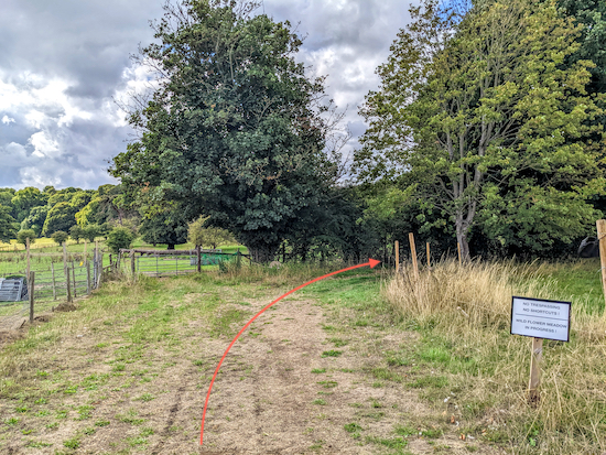 |
| Follow Hertford footpath 107 as it bends right then heads WNW |
9: Follow Hertford footpath 107 as it bends right then heads WNW for 220m until it reaches another corner of the field (location -
https://w3w.co/ranged.kicked.worth), see image below.
 |
| Turn right, still on Hertford footpath 107 then head N |
10: Turn right, still on Hertford footpath 107 then head N for 85m to another junction (location -
https://w3w.co/before.output.puns), see image below.
 |
| Turn left at the junction then follow Hertford footpath 107 into the woodland |
11: Turn left at this junction and follow Hertford footpath 107 as it zig-zags through the woodland for 275m until you reach a stile on the left just as the footpath leaves the woodland (location -
https://w3w.co/meal.flight.pool), see image below.
 |
| Ignore the stile and continue NW |
12: Ignore the stile and continue heading NW for 340m until you reach a right-hand bend (location -
https://w3w.co/folds.scuba.grow), see image at the top of these directions showing Hertford footpath 107 between points 12 & 13.
13: Turn right at the bend then continue following Hertford footpath 107 as it now heads NE for 340m to a gate (location -
https://w3w.co/ship.lives.fields), see image below.
 |
| Go through the gate then head E, with the hedgerow on the left |
14: Go through the gate then head E, with the field on your right and hedgerow on the left, for 200m until you reach a fork in the path (location -
https://w3w.co/depend.cards.twig), see image below. When we tested this walk on 30 August 2022 there were sheep in this field.
 |
| When you reach the fork keep to the right |
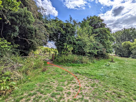
15: When you reach the fork keep to the right. The actual right of way shown on the OS map follows the hedgerow and goes round the edge of the field, but the well-worn path cuts the corner (shown with an orange arrow on the image above).
Head SE then S for 130m until you reach the last house on the left and the path bends to the left after the house (location -
https://w3w.co/parks.pretty.gold), see image below.
 |
| Follow Hertford footpath 107 ESE for 50m |
16: Follow Hertford footpath 107 ESE for 50m until you reach a gate on the left (location -
https://w3w.co/enable.bride.labels), see image below.
 |
| Go through the gate then head NNE along Goldings Lane |
Go through the gate then head NNE along Goldings Lane for 330m until you reach
St Michael and All Angels church (a
Grade II* listed building) on the right (location -
https://w3w.co/stove.vent.chat) and then North Road, the A119 (location -
https://w3w.co/note.trials.fall).
17: Cross the A119 then turn left and follow the pedestrian pavement NNW for 260m until you reach Vicarage Lane on the right (location -
https://w3w.co/secret.saying.vote).
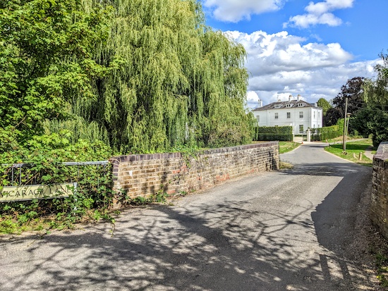 |
| Turn right on Vicarage Lane then head WNW |
Turn right on Vicarage Lane then head WNW for 190m until you reach a footpath on the right (location -
https://w3w.co/traded.newest.maybe), see image below.
 |
| Turn right on Stapleford footpath 2 then enter Waterford Marsh |
18: Turn right on Stapleford footpath 2 then enter Waterford Marsh. Head S for 120m with the hedgerow on the left until you reach a footpath on the left (location -
https://w3w.co/hungry.free.rise), see image below.
 |
| Turn left on Stapleford footpath 2A then head ENE |
19: Turn left on Stapleford footpath 2A then head ENE for 140m until you reach Vicarage Lane (location -
https://w3w.co/modest.fills.hunter).
20: Turn right on Vicarage Lane then follow it for 250m S then E over the railway bridge and back to the car park.
Unlike most of our walks there isn't a pub or cafe on or close to the route. The nearest places to find refreshments are in Bengeo which is about a mile to the south of the start and finish point by road. They are
The Greyhound (location -
https://w3w.co/helps.blunt.calculating),
The White Lion (location -
https://w3w.co/golf.cabin.thick), and
The Secret Garden cafe (location -
https://w3w.co/define.knots.gift).
Interactive map


Really enjoyed this walk. I wondered whether you saw Goldings mansion as there was no mention of it. You had to look back behind you to see it.
ReplyDeleteHi Beryl, yes, we saw the mansion. I did take a photograph but it didn't turn out very well. Glad you enjoyed the walk. David
DeleteHi David Another wonderful walk in this area. One of the shorter walks but wow for me one of the longest in time, so much information to take in and explore. Will definitely walk again in a different season. Thank You. .IR.
ReplyDeleteYes, a lovely walk, and so much to take in. Thanks for the update. Dave
Delete