4.4 miles (7 km) with 73m of total ascent
 |
| Offley footpath 3 between points 4 & 5 |
We have added this walk because we found out that there are plans for a solar farm in the area and we wanted to take the chance to enjoy the rolling Hertfordshire countryside before the landscape changes.
The walk starts and finishes at The Red Lion in Breachwood Green and is one of
four walks that start and finish in the village. It passes close to three other pubs along the way. You will be walking close to Luton airport, so you will hear the planes taking off and landing during the walk.
We didn't see any livestock along the route. The start/finish point is 4.6 miles E from Luton railway station by road.
Getting there
There are bus stops close to the start of the walk which are served by the number 88 bus. You can check bus times at
Intalink.
Fly through preview of walk
If you want to check what sort of landscape you will be crossing before you set off on this walk you can view a short 3D video of the route below. It's created using the free version of
Relive.
Directions
 |
Map for Walk 202: Breachwood Green North-West Loop
Click on the map for larger version
Created on Map Hub by Hertfordshire Walker
Elements © Thunderforest © OpenStreetMap contributors
There is an interactive map below these directions |
Those with GPS devices can download
GPX or
KML files for this walk. We've added
What3Words location references for those who use that system. If you print these walks you might want to use the green
PrintFriendly icon at the bottom of these directions to delete elements such as photographs.
 |
| The Red Lion, Chapel Road, Breachwood Green |
1: With your back to
The Red Lion on Chapel Road, Breachwood Green (location -
https://w3w.co/water.scrubber.beauty) turn left then head N along Chapel Road for 90m until you reach Colemans Road on the left (location -
https://w3w.co/innocence.clasps.winning).
Turn left on Colemans Road then head W for 230m to the point where Colemans Road bends right (location -
https://w3w.co/booster.pampered.identity). Ignore a
footpath on the left then head NW, still on Colemans Road, for 310m ignoring a footpath on the right (location -
https://w3w.co/noble.bunk.faded) and then a
bridleway on the left (location -
https://w3w.co/spare.match.spike), and continue until you reach a footpath on the left (location -
https://w3w.co/insect.vets.just), see image below.
 |
| Turn left on Kings Walden footpath 9 |
2: Turn left on Kings Walden footpath 9 then head NW for 470m until you reach Darley Road at Darley Hall (location -
https://w3w.co/gold.tummy.flash).
3: Turn right on Darley Road then head NE for 45m until you reach a footpath on the left (location -
https://w3w.co/sweep.librarian.affair), see image below.
 |
| Turn left off Darley Road on Kings Walden footpath 32 |
Turn left on Kings Walden footpath 32 then head NW for 90m until you reach a footpath junction (location -
https://w3w.co/spine.bunch.angel), see image below.
 |
| Offley footpath 4 crosses the area of the proposed solar farm |
Keep heading NW, now on Offley footpath 4 for 430m until you reach a farm track with Tankard's Farm on the right (location -
https://w3w.co/cover.traded.gaps).
As you walk along this stretch of Offley footpath 4 look to your left and right to see the land that is being proposed for a solar farm, see images above and below.
 |
| Part of the area included in the proposal for a solar farm |
The proposal for
Wandon End Solar is being promoted by
Evolution Power. The company says the proposed site would
"produce low carbon, affordable, unsubsidised renewable electricity, reducing the UK’s dependence on fossil fuels and its associated carbon impact". According to Evolution Power, if the project goes ahead the panels could be in place for 40 year.
CPRE Herts has
more information about the proposed development. The CPRE site says the industrial nature of the solar panels and associated infrastructure
"would cause harm to this landscape and change the nature of the countryside for more than a generation".
The map below shows the route of this walk in green and the area covered by the proposal for a solar farm in yellow.
Click here or on the map for a larger version.
 |
The area covered by the proposal for a solar farm in yellow
Click here for the sources used in creating this map |
When you reach the farm lane keep heading WNW for 260m until you reach a lane (location -
https://w3w.co/joke.assure.status).
4: Turn left on the lane then head SW for 130m until you reach a footpath on the right immediately after a farm (location -
https://w3w.co/toys.nasal.price), see image below.
 |
| Turn right on Offley footpath 3 |
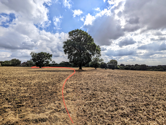
Turn right on Offley footpath 3 then head NW for 340m until the footpath leaves the hedgerow and crosses a field to hedgerow on the far side (location -
https://w3w.co/taking.mice.tubes), see image below. When we tested this route the field had recently been ploughed and the right of way wasn't clear so I have added an orange line to the image below to show the way.
 |
| Offley footpath 3 heads diagonally across a field for 80m |
When you reach the other side of the field turn left then head NW, with the hedgerow on the right and the field on the left, for 60m until you reach Brick Kiln Wood (location -
https://w3w.co/went.tell.gears). As soon as you enter Brick Kiln Wood you will come to a junction (location -
https://w3w.co/elaborate.finds.spicy), see image below.
 |
| Take the right fork then continue heading NW |
Take the right fork then continue heading NW, still on Offley footpath 3 for 130m until you reach Brick Kiln Lane (location -
https://w3w.co/dream.donor.sunset).
 |
| Offley footpath 3 heading NW through Brick Kiln Wood |
5: Turn left on Brick Kiln Lane then head NW for 480m until you reach a junction (location -
https://w3w.co/steps.hint.frock).
6: Turn left on Chalk Hill then head WSW for 85m until you reach a footpath on the right (location -
https://w3w.co/shed.range.stacks), see image below.
 |
| If you want to visit The King William IV pub take the footpath on the right |
* At this point you could take a detour to visit The King William IV pub in Mangrove Green. To reach the pub, turn right on Offley footpath 25 then head NW for 300m until you reach a lane. Turn right on the lane then head N for 170m to the pub. To rejoin the route head S from the pub for 500m to point 7 in the directions.
If you don't take the detour to the pub continue heading WSW along Chalk Hill and through the village of Cockernhoe. After 150m you will pass a magnificent oak tree on the right which was planted in 1953 (location -
https://w3w.co/drop.shapes.proven), see images below.
 |
| The coronation oak on Cockernhoe village green |
 |
| The coronation oak plaque on Cockernhoe village green |
Continue past the coronation oak, now on Luton Road, for 55m until you reach the junction with Mangrove Road (location -
https://w3w.co/voters.boom.burns).
7: Keep left on Luton Road then head S for 240m looking for a footpath on the left (location -
https://w3w.co/fish.race.squad), see image below.
 |
| Turn left on Offley footpath 2 |
8: Turn left on Offley footpath 2 then follow the footpath SSE for 360m until it bends to the right and then immediately left (location -
https://w3w.co/energetic.league.images), see image below.
 |
| Offley footpath 2 cuts in and out of the woodland |
Offley footpath 2 now cuts in and out of the woodland and alongside fields for 820m until you reach Darley Road at Wandon End. (location -
https://w3w.co/pays.rabble.jets). It's important not to miss the points where Offley footpath 2 dips into the woodland. The two most important turns are pictured below along with their What3Words references.
 |
| The first turn into the woodland - What3Words ref below |
The first turn into the woodland is at (location -
https://w3w.co/dates.inch.parent), see image above. The second turn into the woodland is at (location -
https://w3w.co/moment.talent.deals), see image below.
 |
| The second turn into the woodland - What3Words ref above |
9: When you reach Darley Road, cross the triangle at the junction then take the footpath on the opposite side of Darley Road (location -
https://w3w.co/retail.hush.clubs), see orange line on the image below.
 |
| Take this footpath then head E |
Take this footpath then head E along the south side of Darley Road for 550m until you reach a road junction (location -
https://w3w.co/urgent.angel.glory), see image below. You will be close to Luton airport at this stage.
 |
| Head E along Darley Road until you reach a bridleway on your right |
10: Head E along Darley Road for 80m until you reach a bridleway on your right at the point where the road bends left (location -
https://w3w.co/baked.hunt.basket), see image below.
* When you reach the bridleway you have the option of taking a 350m detour NW along the lane you are on to The Fox at Darley Hall.
 |
| Turn right on Kings Walden bridleway 52 |
Turn right on Kings Walden bridleway 52 then follow it ESE for 620m to a junction (location -
https://w3w.co/second.librarian.hidden), see image below.
 |
| Turn right on Kings Walden footpath 6 |
11: Turn right at the junction then head S on Kings Walden footpath 6 for 25m at which point the path bends left then heads E (see orange arrow on the image above) for 330m to another junction (location -
https://w3w.co/latest.shrimp.online), see image below.
 |
| Turn right then head S for 30m then left again, still on Kings Walden footpath 6 |
12: Turn right then head S for 30m then left again, still on Kings Walden footpath 6 (see direction of orange arrow on the image above), then follow the footpath ESE for 170m until the path crosses a field and reaches an oak tree (location -
https://w3w.co/booklets.fillings.scorching), see image below.
 |
| Follow Kings Walden footpath 6 to the left of the oak to another oak |
Keep to the left of the oak then follow Kings Walden footpath 6 as it bends left and head NE to another oak before bending right then heading E for 110m to Chapel Road in Breachwood Green (location -
https://w3w.co/secrets.crowned.gossiping), see orange line on the image above.
13: Turn left on Chapel Road then head N for 200m back to the stating point.
Interactive map
Attribution
The satellite image map of the site of the proposed solar farm is courtesy of the following sources: Esri, DigitalGlobe, GeoEye, Earthstar Geographics, CNES/Airbus DS, USDA, USGS, AEX, Getmapping, Aerogrid, IGN, IGP, swisstopo, and the GIS User Community. The map was created on MapHub by Hertfordshire Walker.


Another lovely walk with great views . Especially liked Brick Kiln Wood the earthy smell this time of year . Thank you . Unfortunately came across two fly tippings. Have reported it . .IR.
ReplyDeleteWhat a pity about the fly tipping. Well done reporting it.
DeleteFYI In Oxford Road , a few yards from the start of this walk there is a bus shelter where you can change into your boots in comfort, there are also books available!
ReplyDelete