4.8 miles (7.7 km) with 72m of total ascent
 |
| The pond at Standon Lodge Farm between points 3 & 4 |
This is our third walk from the village of Standon. This route explores the countryside to the south-east. The route offers great views over open fields. It starts and finishes at The Star on High Street Standon where there is another pub, The Bell, and Days Bakery which serves tea, coffee, and cold drinks.
There are several sections along the way where dog owners are urged to keep their dogs on a lead, and the route passes through one field which, when we did the walk, had a 'Bull in field' sign. We saw the bull, but he took no notice of us. However, I have added a detour for those who don't want to enter a field if there is a bull present.
Getting there
There are bus stops close to the start of the walk (location -
https://w3w.co/clerics.destroyer.recliner) which are served by the number 386 bus. There are other stops in the village served by the numbers 36, 36A, and 331. You can check bus times at the
Intalink site.
Fly through preview of walk
If you want to check what sort of landscape you will be crossing before you set off on this walk you can view a short 3D video of the route below. It's created using the free version of
Relive.
Directions
 |
Map for Walk 200: Standon South-East Loop
(click here or on the map for larger version)
Created on Map Hub by Hertfordshire Walker
Elements © Thunderforest © OpenStreetMap contributors
There is an interactive map below these directions |
Those with GPS devices can download
GPX or
KML files for this walk. We've added
What3Words location references for those who use that system. If you print these walks you might want to use the green
PrintFriendly icon at the bottom of these directions to delete elements such as photographs.
 |
| The Star on Standon High Street |
1: With your back to
The Star on Standon High Street (location -
https://w3w.co/field.jugs.drones) turn right then head S for 80m passing St Mary's Church on the left (location -
https://w3w.co/puppets.happier.rural) and continuing to the junction with Paper Mill Lane and Hadham Road (location -
https://w3w.co/freezers.mouse.blossom).
Turn left at the junction then head E along Hadham Road for 350m until you reach a right hand bend and a footpath straight ahead heading E (location -
https://w3w.co/collide.fatherly.onions), see image below.
* There isn't a pedestrian pavement along this stretch of Hadham Road, but if you want to avoid the traffic you will find a path on the left that climbs to run alongside the houses and parallel to the road before rejoining Hadham Road after the houses.
 |
| Take the path at the bend, Standon footpath 5 |
2: At the bend take Standon footpath 5, then head first E then NE for 730m to a junction (location -
https://w3w.co/typed.enveloped.detained), see image below.
 |
| Turn right on Standon restricted byway 6 |
3: Turn right on Standon restricted byway 6. Immediately after turning right you will come to a gate which, when we did the walk on 20 August 2022 had a "Bull in field" sign, see image below.
 |
| Standon restricted byway 6 heading through a field of livestock |
The distance between the gate into the field and the gate out of the field is 180m. We saw the bull lying on the ground while a herd of cows ate their lunch. They paid no attention to us and the bull didn't even look up or get up.
 |
| Livestock grazing off Standon restricted byway 6 |
If you are worried about crossing a field if there is a bull in it there is a detour you can take, which is marked in orange on the map below. There are also directions for the detour below the map. If you take the detour you will miss the pond pictured at the top of this page.
 |
| Detour between points 3 & 4 in orange |
* Detour to avoid 'Bull in field': When you reach point 3, instead of turning right on Standon restricted byway 6, keep heading NE on Standon footpath 5 for 100m until you reach Froghall Lane (location - https://w3w.co/mammoths.straddled.reduction). Turn right on Froghall Lane then head E for 420m to a junction (location - https://w3w.co/less.handlebar.remodel). Turn right at the junction then head SSE along a lane for 360m until you reach another junction (location - https://w3w.co/lend.encoding.pleasing). Turn right at the junction then head SW along a lane for 320m until you reach Standon footpath 11 on the left (location - https://w3w.co/blizzard.evaded.treatment) where you can rejoin the route.
If you don't take the detour, go through the gate mentioned in point 3 then continue heading SSE through a field on Standon restricted byway 6 for 180m, with the hedgerow on the left and field on the right, until you reach a gate leading to a farmyard (location -
https://w3w.co/holiday.advice.lawns). Continue heading SSE with the farm buildings on the left for 70m until you reach a pond on the right (location -
https://w3w.co/peach.pills.houseboat), see image below.
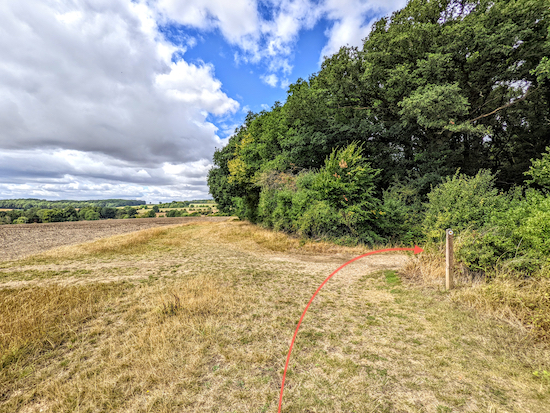
Once past the farm head S, still on Standon restricted byway 6, for 290m until you reach a lane (location -
https://w3w.co/anchors.modest.prospered). Turn left then head ENE for 250m looking out for a footpath on the right (location -
https://w3w.co/roofs.buns.breaches), see image below.
 |
| Turn right on Standon footpath 11 |
4: Turn right on Standon footpath 11 then head SE for 750m until you reach Bromley Lane (location -
https://w3w.co/trumped.admire.professes). Turn left on Bromley Lane then head N for 15m looking out for a double right of way sign on the right (location -
https://w3w.co/handbag.woke.presuming), see image below.
 |
| Take the first path on the right, Standon footpath 76 |
5: When you reach the right of way sign on the right be sure to take the first path on the right, Standon footpath 76, then head SSE for 300m crossing several footbridges until you reach the footbridge pictured below (location -
https://w3w.co/energetic.lies.soaks).
 |
| The final footbridge on Standon footpath 76 |
Once across the footbridge, which is the last you will cross on Standon footpath 76, head straight and SE with the hedgerow on the right and field on the left until you reach the end of the hedgerow (location -
https://w3w.co/pillow.trendy.first), see image below. This is a complicated part of the walk, which I have shown with an orange arrow on the image below.
 |
| Follow the line of the orange arrow down to the vineyard then uphill |
6: At the end of the hedgerow follow the path down to the vineyard (see orange line on the image above) then keep right until you reach a track heading uphill to your right (location -
https://w3w.co/cats.poker.crush). Follow the track SW and uphill along a line of telegraph poles for 300m until you reach Bromley lane, see images below.
 |
| Follow the track uphill and alongside the telegraph poles |
 |
| Head SW and uphill until you reach Bromley Lane |
7: Turn left on Bromley Lane then head S for 125m until you reach a bridleway on the right (location -
https://w3w.co/nods.stroke.knots), see image below.
 |
| Turn right on Standon bridleway 82 |
8: Turn right on Standon bridleway 82 then head SE for 1.1km, ignoring a footpath on the right along the way (location -
https://w3w.co/robot.regard.mercy), and continuing until you reach a junction just beyond woodland (location -
https://w3w.co/smashes.trap.cycles), see image below.
 |
| Turn right on Standon bridleway 19 |
9: Turn right on Standon bridleway 19 then, with the trees on your right and field on your left, head NW for 790m until you reach Standon Lodge Farm (location -
https://w3w.co/closes.loaf.slam). Keeping the farm buildings on your left head N for 180m until you reach a junction with a lake on the left (location -
https://w3w.co/novel.reader.newly), see image below.
 |
| Turn left at the junction, still on Standon bridleway 19 |
 |
| The lake on the left of Standon bridleway 19 |
10: Turn left at the junction beyond the lake, still on Standon bridleway 19, then head NW for 750m until you reach a junction (location -
https://w3w.co/puff.dices.direct), see image below.
 |
| Turn right at the junction on Standon footpath 24 |
11: Turn right at the junction, now on Standon footpath 24, then follow it N for 370m to a footpath junction (location -
https://w3w.co/shatters.streetcar.outsmart), see image below.
 |
| Turn left, still on Standon footpath 24 |
12: Turn left at the junction, still on Standon footpath 24, then follow it WNW for 260m until it turns right into woodland (location -
https://w3w.co/clockwork.latter.plays), see image below.
 |
| Turn right then head N still on Standon footpath 24 |
13: Turn right then head N through the wood, still on Standon footpath 24, then continue for 490m until you reach Hadham Road (location -
https://w3w.co/shopper.spoke.dictation). There are signs warning dog owners to keep their pets on a lead through the woodland.
14: Turn left on Hadham Road then follow it WNW then N for 220m back to
The Star and the start of the walk.
 |
| One of the houses in Standon village |
There are two pubs and a bakery on Standon High Street. The pubs are
The Star (location -
https://w3w.co/protected.submerged.final) and
The Bell (location -
https://w3w.co/jingles.enthused.path), and
Days Bakery (location -
https://w3w.co/cubed.rhino.spaces) which is situated between the two pubs.
If you enjoyed this walk you might want to join
our friendly Facebook group where fellow walkers are sharing photographs and experiences after following our walks in the Hertfordshire countryside.
Interactive map


Hi Dave another enjoyable walk with great views on route will do it again in better weather than today . Must admit at point three the Bull half way up the hill looked at me ,I looked at him, he looked at me again. OK I took the Orange Route 🤣😂🤣 Thanks for the walk and instructions. .IR.
ReplyDeleteGlad you didn't challenge the bull. When you wrote 'the Bull half way up the hill' I thought you had found a pub I had missed. :-)
DeleteDave
That’s your wishful thinking Dave 🤣😂
ReplyDelete:-)
DeleteNo sign of the bull yesterday or any livestock and upon reaching the top of the field the reason for this became apparent. The cows are in the barn for calving and we witnessed a new arrival which was very special. Really enjoyed the walk- highly recommend it.
ReplyDeleteThanks for the feedback and for the report and photo on our Facebook group. Appreciated.
DeleteThe cattle were all sitting down basking in the sunshine and ignored me!
ReplyDeleteHi Gerry, they probably figured out your are a nice guy and meant no harm. :-)
Delete