5.6 miles (9.1 km) with 118m of total ascent
 |
| A field of poppies just after point 9 in the directions below |
This lovely linear walk between Hertford North Station and Watton-at-Stone Station follows the River Beane. The route crosses Waterford Marsh and Waterford Heath, and passes through the grounds of Woodhall Park. There are two pubs close to the finish point, The George and Dragon and The Bull, as well as Crumbs bakery and cafe. A short detour to visit all three is included towards the end of the directions. There is one pub, The Millstream, close the start of the walk.
Getting there
There are bus stops close to Hertford North Station at the start of the walk (location -
https://w3w.co/sands.rivers.next), which are served by the following buses, numbers 324, 341, 378, 379, 390, 395, 641, and 724. There is also bus stops at Watton-at-Stone Station at the end of the walk which is served by the number 201 bus. You can check bus times at
Intalink.
Fly through preview of walk
If you want to check what sort of landscape you will be crossing before you set off on this walk you can view a short 3D video of the route below. It's created using the free version of
Relive.
Directions
 |
Map for Walk 182: Hertford to Watton-at-Stone Linear
Click on the map for a larger version
Created on Map Hub by Hertfordshire Walker
Elements © Thunderforest © OpenStreetMap contributors
There is an interactive map below the directions |
Those with GPS devices can download
GPX or
KML files for this walk. We've added
What3Words location references for those who use that system. If you print these walks you might want to use the green
PrintFriendly icon at the bottom of these directions to delete elements such as photographs.
1: Leave Hertford North Station at the North Road exit (location -
https://w3w.co/ripe.intervals.merit), then cross North Road via the pedestrian crossing. Once on the other side, turn left then head NNE for 40m until you reach Beane Road on the right (location -
https://w3w.co/meant.leader.agreed). Turn right on Beane Road then head NE for 310m until you reach Molewood Road on the left (location -
https://w3w.co/humid.bath.fish).
* I realise it's early in the walk, but if you already need refreshments there is a pub a short walk from this point. It's The Millstream (location - https://w3w.co/daring.lung.score), 115m to the right along Port Vale.
2: Turn left on Molewood Road then head NNW for 290m until you reach a footpath going uphill to the right (location -
https://w3w.co/shot.pipes.corner).
 |
| Ignore the footpath on the right and continue heading NNW |
3: Ignore the footpath on the right, see image above, and continue heading NNW, now on Hertford footpath 95, for 285m until you reach Molewood House on the left and the former Borough of Hertford Water Works on the right (location -
https://w3w.co/sounds.limit.error).
Those interested in industrial archaeology might want to look out for the old Hertford Water Works at this point, as well as some leftover pieces of machinery.
 |
| Hertford Water Works erected 1888 |
 |
| Rusting water works machinery |
 |
| Sluice gates further along the River Beane |
 |
| Turn left on Hertford footpath 93 |
4: Turn left after Molewood Lodge on Hertford footpath 93, see image above, then head NW, passing under the railway line (location -
https://w3w.co/talent.swift.groups), then continuing for 295m until you reach North Road, the A119 (location -
https://w3w.co/trails.trim.either).
5: Turn right on North Road then head N along the pedestrian pavement for 360m looking out for a footpath on the right just before a bridge over the River Beane (location -
https://w3w.co/gaps.guitar.apple).
 |
| Turn right on Hertford footpath 26 |
6: Turn right on Hertford footpath 26, then follow it NE for 50m until you reach a gate leading to
Waterford Marsh, see image below.
 |
| The entrance to Waterford Marsh on Hertford footpath 26 |
Continue heading NE, then NW across Waterford Marsh keeping close to the eastern bank of the River Beane on your left.
After 890m the path you are on crosses the parish boundary and becomes Stapleford footpath 2 (location -
https://w3w.co/chin.nation.rider). This is a lovely stretch with several benches facing the river for those who want to take a break and soak in the view.
 |
| Hertford footpath 26 running alongside the River Beane |
Continue to follow Stapleford footpath 2 N for 400m until you reach Vicarage Lane in Waterford (location -
https://w3w.co/thank.crowds.test).
 |
| Stapleford footpath 2 continuing at the end of Barley Croft |
7: Turn right on Vicarage Lane then head E for 60m until you reach Barley Croft on the left (location -
https://w3w.co/crust.rises.cafe). Turn left on Barely Croft then head N for 105m, still on Stapleford footpath 2, until you pass the last house (location -
https://w3w.co/boxer.twigs.letter), see image above. Follow the path for 145m, crossing a field and continuing until you reach a tunnel under the railway, see image below.
 |
| Go under the railway line again and continue heading NNE |
 |
| The route follows the River Beane through Waterford Heath |
Go under the railway line (location -
https://w3w.co/from.beams.donor) and continue heading NNE, still on Stapleford footpath 2, through the river section of
Waterford Heath for 280m until you reach Bullsmill Lane (location -
https://w3w.co/fingernails.shovels.films).
 |
| The track on the right off Bullsmill Lane |
8: Turn left on Bullsmill Lane then head N for 50m until you reach a track on the right (location -
https://w3w.co/final.wires.alert), see image above. Turn right on the track then follow it NNE for 220m until it bends right. Ahead you will see a footpath sign to the right of a gate (location -
https://w3w.co/fell.drops.moss).
 |
| Head NNE on Stapleford footpath 3 for 120m until you reach a junction |
9: Take this footpath, Stapleford footpath 3, and head NNE for 120m until you reach a junction. Keep left, still on Stapleford footpath 3 (location -
https://w3w.co/bumpy.speak.warm), following the path into woodland. The footpath heads NNW for 85m before heading NNE, N, then NNW alongside the eastern bank of the River Beane for 915m until it reaches Church Lane, Stapleford (location -
https://w3w.co/fonts.vent.proof).
 |
| Sacombe footpath 18 at the end of Clusterbolts |
10: Turn right on Church Lane then head E for 50m until you reach Clusterbolts on the left (location -
https://w3w.co/rush.venues.fits). Head NNE along Clusterbolts for 240m until you reach a footpath to the left of the last house (location -
https://w3w.co/card.aware.living), see image above.
 |
| Sacombe footpath 18 with the River Beane on the left |
Take this path, Sacombe footpath 18, then follow it N, NNE, then N for 590m until you reach a junction (location -
https://w3w.co/worker.flock.casino).
 |
| Sacombe footpath 18 heading NNE |
11: Continue heading NNE, still on Sacombe footpath 18, for 370m until the path crosses the parish boundary and becomes Watton-at-Stone footpath 12A (location -
https://w3w.co/stage.bonds.charm).
 |
| Go through the metal gate then continue NNE for 60m to a junction |
Keep heading NNE, now on Watton-at-Stone footpath 12A, go through a metal gate, then continue heading NNE for 60m until you reach a footpath junction (location -
https://w3w.co/drove.chips.unless).
 |
| Turn left on Watton-at-Stone footpath 10A then head NNW |
Turn left on Watton-at-Stone footpath 10A then head NNW for 70m to a stone bridge just before a footpath junction (location -
https://w3w.co/almost.remark.bolt), see image below. You are now walking through
Woodhall Park.
 |
| Cross the bridge then turn left on Watton-at-Stone footpath 10 |
Cross the bridge then turn left on Watton-at-Stone footpath 10. Head W for 110m at which point the path you are on becomes Watton-at-Stone footpath 12 (location -
https://w3w.co/store.stored.tribune).
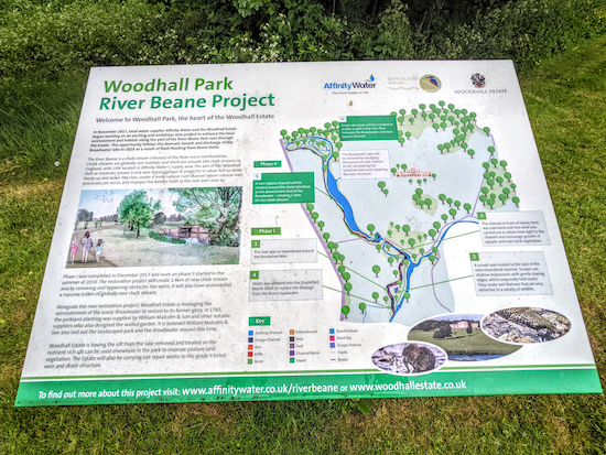
Look out for information boards explaining the environmental work that is being carried out as part of the
Woodhall Park River Beane Project.
 |
| River Beane flowing through Woodhall Park |
 |
| Weir on River Beane in Woodhall Park |
 |
| The widened section of the River Beane through Woodhall Park |
Evidence of the River Beane Project is visible in all directions at this point. It was raining heavily when we walked this stretch at the end of May 2022 and so the photographs, above, are not great. Keep heading W, now on Watton-at-Stone footpath 12, for 620m crossing the River Beane (location -
https://w3w.co/burns.timing.lend) and continuing until you reach the A119 (location -
https://w3w.co/elite.jumped.bumpy).
 |
| Cross the A119 then take the footpath on the opposite side |
12: Cross the A119, taking the footpath on the opposite side. This is Watton-at-Stone footpath 24, which you follow NW for 60m to a junction (location -
https://w3w.co/pile.table.sing).
 |
| The junction where you can follow Watton-at-Stone footpath 24 or take a detour |
Here you have two options. You could continue to follow Watton-at-Stone footpath 24 for 910m crossing a field, walking through a short stretch of woodland, and across another field until you reach Perrywood Lane (location -
https://w3w.co/counts.page.prep), or, if the field has recently been ploughed or planted and not yet reinstated, there is an alternative detour along a permissive path and a public right of way. Both end up at the same point. I have included a map showing the detour in orange below.
 |
The optional detour mentioned above in orange
Click here or on the map for a larger version
Created on Map Hub by Hertfordshire Walker
Elements © Thunderforest © OpenStreetMap contributors |
13: Turn right on Perrywood Lane then head N for 120m until you reach Church Lane on the left (location -
https://w3w.co/album.wide.tulip). Turn left on Church Lane.
* Just past the church of St Andrew and St Mary on Church Lane, there is a footpath which offers the option of a detour for refreshments. There are two pubs and a cafe in Watton-at-Stone. They are The Bull (location - https://w3w.co/over.fruit.vouch), The George and Dragon (location - https://w3w.co/wakes.intent.frozen) and Crumbs Bakery and Cafe (location - https://w3w.co/dance.reds.race). If you take that detour (see map below), you can continue to Watton-at-Stone station after your refreshments by heading NW on High Street then turning left and heading SW on Station Road to Watton-at-Stone station.
 |
The detour in orange for those wanting refreshments
Click here or on the map for a larger version
Created on Map Hub by Hertfordshire Walker
Elements © Thunderforest © OpenStreetMap contributors |
If you don't take the detour, head NW for 305m along Church Lane looking out for a footpath on the right (location -
https://w3w.co/brains.look.gently).
 |
| Turn right on Watton-at-Stone footpath 17 |
14: Turn right on Watton-at-Stone footpath 17 then follow it NW for 190m until you reach Glebe Close (location -
https://w3w.co/newest.scars.escape). Head N along Glebe Close for 140m until you reach Station Road (location -
https://w3w.co/taken.settle.spoke).
 |
| Watton-at-Stone station at the end of the walk |
15: Turn left on Station Road then head WSW for 140m to Watton-at-Stone station (location -
https://w3w.co/about.slick.finely).
If you have any comments about this walk, or tips for other walkers, please use the comment box at the foot of these directions. Thanks
And thanks to Mustafa Suleman for suggesting we map, test and add this walk to our collection.
Interactive map


I walked this a couple of weeks ago on a sunny day. Lovely walk - thank you for the directions! I stopped at Crumbs Cafe for late lunch and can recommend it
ReplyDeleteGreat, glad you enjoyed it. And thanks for the tip about Crumbs Cafe. David
DeleteDid this walk a few weeks ago. Really pretty and quiet. Your instructions are excellent, Thank you!
ReplyDeleteSo glad you enjoyed it. We really like that walk too. Thanks for the feedback.
DeleteThis was a beautiful walk with an interesting variety of terrain. Enjoyed it immensely and intend to repeat in summer and in reverse (see point 5 below!) Notes:
ReplyDelete1. Ref. points 2 & 3: it's Molewood, not Moleswood and Molewood Lodge appears to have changed its name (to Molewood House IIRC but anyway not Lodge).
2. Ref. point 7: the last house had a car parked in front of it obscuring the view of the footpath entrance. If there's a car you have to go round behind it. Ignore the locked metal gate which is not the footpath.
3. Ref. point 11: the directions and picture imply that after going through the gate you take a path (clear on picture) to the right of the tree. This path wasn't there, no way makers and after much deliberation we bore left through the field which turned out to be correct.
4. DO NOT miss out point 13, as we did and ended up going the wrong way.
5. The final section from about point 12 onwards is uphill.
Great feedback, thanks. I will go through all your points when I am in front of my computer and update the directions where required. David
DeleteLovely walk yesterday. The wild flowers were beautiful by the river bank. Train back to Hertford.
ReplyDeleteGlad you enjoyed it. The wildflowers are amazing this year - the best I have seen for some time.
DeleteJust back from doing this walk today, in the wintry early December sunshine - but it was dry! Really enjoyed it - thank you! Directions are very clear and the footpaths are well marked. We saw an egret, buzzards and several large kites. All in all a very good day's walking. We ended with a good lunch in The Bull (The other pub was full!) and a stroll back to the station. THANK YOU!
ReplyDeleteSounds like a perfect day. So glad you enjoyed it. We really like that walk.
DeleteJust did this walk in the early spring sunshine - it was lovely. Clear instructions and guidance.
ReplyDeleteThis website is a gem for London dwellers like me who need train access to walks and the countryside. Thank you so much for all work putting it together!
Great to know the walks work for you regarding the trains. Thanks for the feedback.
DeleteWe completed this very pleasant and enjoyable walk today - it was our first "proper" walk this year for various reasons and we chose it because it was accessible by public transport. It took us 3 hours, including a break to eat our sandwiches.
ReplyDeleteIf people use the trains, be aware that contactless payment is available at Hertford North, but not at Watton-at-Stone, where you need to buy a ticket at the machine.
Thanks for the travel tip Richard
DeleteThank you thank you thank you so much for this walk. After weeks of rain we desperately wanted to get a good walk in. And we weren't disappointed. Such a beautiful walk. Looking forward to doing it in the summer. The v clear instructions made it a total hour.
ReplyDeleteSo glad you enjoyed it. It's a lovely walk. Thanks for the feedback. David
Delete