This walk follows The Cole Green Way, a former branch line between Hertford and Welwyn Garden City which is now a long-distance recreational route. Our route starts at the former Cole Green Station, then heads W before looping round through Panshanger Park. There is a pub, The Cowper Arms, close to the start of the walk. Be sure to check opening times.
Getting there
For those travelling by bus there are three options. There are bus stops on Cole Green Lane close to point 3 in the walk (location - https://w3w.co/liked.blues.wheels) which are served by the number 201 and 324 buses. There are also bus stops in Birch Green close to point 13 (location - https://w3w.co/city.press.powers) which are served by number 324 and 641 buses and close to point 14 (location - https://w3w.co/shunts.pushy.riding) which are served by the number 380 bus. You can check bus times at Intalink.
Fly through preview of walk
If you want to check what sort of landscape you will be crossing before you set off on this walk you can view a short 3D video of the route below. It's created using the free version of Relive.
Those with GPS devices can download GPX or KML files for this walk. We've added What3Words location references for those who use that system. If you print these walks you might want to use the green PrintFriendly icon at the bottom of these directions to delete elements such as photographs.
Cole Green station platform and The Cole Green Way
1: Standing on the former station platform and facing what would have been the track (location - https://w3w.co/dots.chemistry.breath), turn right then head W along the platform then down the ramp to join the Cole Green Way. Follow the route of the old railway line for 980m until you reach a tunnel under Hatfield Road, the A414 (location - https://w3w.co/putty.smiles.paint), see image below.
Continue through the underpass beneath the A414
2: Go through the underpass. As you do take time to study some of the murals either side, some of which have been created by artist Mark Tanti who goes by the name Demograffix. Below is a selection of Mark's work.
Underpass mural by Demograffix
Underpass mural by Demograffix
Mark explains more about his work in the following YouTube video.
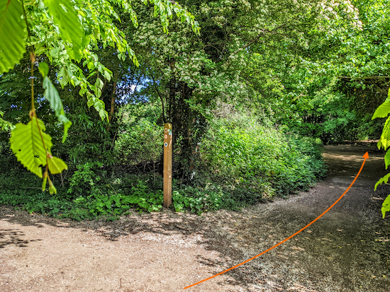
Continue along the Cole Green Way, which is paved at this point. Head NW for 1.5km until you reach Cole Green Lane (location - https://w3w.co/makes.assist.sheets), see image below.
Cross Cole Green Lane keep right then turn left on Black Fan Road
3: Cross Cole Green Lane then keep right and head NE for 50m until you reach Black Fan Road (location - https://w3w.co/leans.estate.joke), see orange arrows on the image above. Keep left alongside Black Fan Road heading NW for 70m looking for a gate on the other side of the road (location - https://w3w.co/levels.else.visual).
Welwyn Garden City bridleway 69 off Black Fan Road Image courtesy of Gerry Gross
Go through the gate then Head NE on Welwyn Garden City bridleway 69, which is also known as Green Lane, see image above.
The remains of the WWII bunker Image courtesy of Gerry Gross
Continue heading NE, still on Green Lane, for 480m
4: Continue heading NE, still on Green Lane, for 480m with playing fields through the trees on your left, until you reach a junction where several tracks head off into the woodland (location - https://w3w.co/occurs.plug.hits).
Green Lane after point 4
When you reach the junction (point 5) keep straight and to your right
5: When you reach the junction keep straight and to your right, then head W for 150m until the path bends left (location - https://w3w.co/axed.cliff.burns), see image below.
The path bends left then heads N with the fields on the right
The turn mentioned in point 5 above is marked with an A on the map below.
Continue to follow this path through woodland with the fields on your right, first N for 150m to a right-hand bend (location - https://w3w.co/zoom.chained.system), marked with a B on the map above. Then head NE for 120m to another bend to the right (location - https://w3w.co/finds.craft.space), marked with a C. Then head ESE for 310m until you reach Panshanger Lane (location - https://w3w.co/debit.rats.folds).
The entrance to Butterfield Way off Panshanger Lane
6: Turn left on Panshanger Lane then head NE for 50m looking out for a footpath on the right marked Butterfield Way (location - https://w3w.co/rear.bump.bill), see image above.
The Butterfield Way heading ESE
Head ESE for 190m along Butterfield Way until the path joins a track (location - https://w3w.co/rails.kicks.bonds), see image below.
8: Take the middle path to the right of the gate then continue heading ENE for 140m to a track (location - https://w3w.co/calms.game.giving). Cross the track then continue ENE for 160m until you reach a junction (location - https://w3w.co/cable.grant.tops), see image below.
Turn right at the junction on Hertingfordbury footpath 10
9: Turn right at the junction on Hertingfordbury footpath 10 then follow it SE and uphill for 560m until you reach a path going off to the left (location - https://w3w.co/wished.audio.piper).
Head SE on Hertingfordbury footpath with Forty Acres on the right
10: Ignore this path and continue heading SE for 360m with the woodland on your left and an area called Forty Acres on the right.
Forty Acres information board, Panshanger Park
According to a sign along the way:
"Forty Acres is an area of grassland and wetland pools. The area provides nesting places for solitary wasps and bees which dig burrows in the bare ground. The area also provides habitat for migrant birds such as the rare little ringed plover. Ditches and ponds provide breeding places for amphibians such as frogs, toads and newts and in the summer you will see plenty of wild flowers".
At this point you will begin to hear the noise of traffic on the A414 which you are approaching. Continue until you reach a junction (location - https://w3w.co/mice.famed.forms).
Keep right at the junction to continue on Hertingfordbury footpath 10
11: When you reach the junction (see image above) keep right and continue heading SE, still on Hertingfordbury footpath 10. Cross a quarry track (location - https://w3w.co/flight.entry.impose) then continue heading SE until you reach another junction, see image below (location - https://w3w.co/foil.modes.cost).
Hertingfordbury footpath 10 heading to the footbridge over the A414
Keep right at the junction then follow Hertingfordbury footpath 10 up a ramp and across a footbridge over the A414 (location - https://w3w.co/snow.curve.limbs).
Once across the bridge, ignore a footpath on your right
12: Once across the bridge you will come to a junction (see image above) where Hertingfordbury footpath 10 turns to the left (location - https://w3w.co/acid.robot.daily). You head S at this point along a permissive path, with a hedgerow on the left and a field on the right. Continue for 300m until you reach The Old Coach Road (location - https://w3w.co/slower.view.combining). Turn left on The Old Coach Road then head E for 210m until you reach Birch Green on the right (location - https://w3w.co/senses.pouch.scuba).
Turn left on The Old Coach Road then turn right on Birch Green
13: Turn right then head S on Birch Green for 450m looking for a footpath on the right just after the road bends right (location - https://w3w.co/give.guises.socket). If you are in need of refreshments at this point, look out on the left as you walk along this stretch for the Four Rivers Coffee (location - https://w3w.co/frock.voters.uses). Check opening times to avoid disappointment.
Take the footpath between the houses, Hertingfordbury footpath 7
14: Take this path, Hertingfordbury footpath 7, then follow it W for 60m to a field.
Hertingfordbury footpath 7 heading SW to Cole Green Way
Great walk, took a group of 17 (children and older adults), all really enjoyed the walk.Easy and fun. Great start and finish with a lovely lunch at the Cowper arms.
The sun was shining so that made for another good walk today. Heads up for anyone doing this walk in the next few days that there is a tree down blocking the footpath about 50m after the bridge mentioned at point 12 (location - https://w3w.co/dish.strict.lifts) also the Four Rivers cafe is now closed down. None of that spoiled the walk. This is a great website, I'm looking forward to many more walks throughout the year
Comments and feedback If you try any of the walks on this site, please let us know what you thought of them by adding a comment here or on our members-only Facebook group. Comments here are checked before they are published. Comments on the Facebook group go live immediately.


Great walk, took a group of 17 (children and older adults), all really enjoyed the walk.Easy and fun. Great start and finish with a lovely lunch at the Cowper arms.
ReplyDeleteGreat to hear. So glad you all enjoyed it.
DeleteThoroughly enjoyed this walk. Only one hill that didn't last for long. I love rolling countryside views and the end part of the walk provided this.
ReplyDeleteYes, it's a nice walk. Hope the hill didn't spoil it.
DeleteNot atall. Was fabulous.
ReplyDeleteThe sun was shining so that made for another good walk today. Heads up for anyone doing this walk in the next few days that there is a tree down blocking the footpath about 50m after the bridge mentioned at point 12 (location - https://w3w.co/dish.strict.lifts) also the Four Rivers cafe is now closed down. None of that spoiled the walk. This is a great website, I'm looking forward to many more walks throughout the year
ReplyDelete