5.5 miles (8.8km) with 109m of total ascent
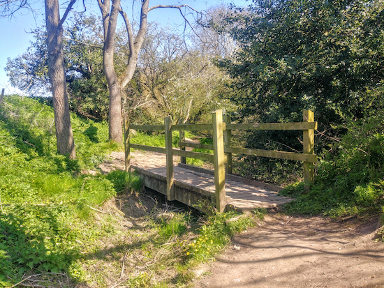 |
| A footbridge over Braughing Bourne |
A circular walk from the village of Braughing along the attractive Braughing Bourne, across open countryside with views on all sides, through shady woodland following winding footpaths, and along byways and bridleways. Towards the end children, dogs and adults have the chance for a paddle in a clear running river at a ford. There are three pubs in the village.
Fly through preview of walk
If you want to check what sort of landscape you will be crossing before you set off on this walk you can view a short 3D video of the route below. It's created using the free version of
Relive.
Directions
 |
Map for Walk 129: Braughing North-East Loop
Click on the map for a larger version
Created on Map Hub by Hertfordshire Walker
Elements © Thunderforest © OpenStreetMap contributors
There is an interactive map below these directions |
Those with GPS devices can download
GPX or
KML files for the walk. We've added
What3Words location references for those who use that system. If you print these walks you might want to use the green
PrintFriendly icon at the bottom of these directions to delete elements such as photographs.
 |
| Turn right on Braughing bridleway 6 when the lane bends left |
1: With your back to
The Brown Bear in Braughing village turn right then head NNE along The Street heading uphill until the road forks. Take the left fork and continue N for 260m until the road bends left and you reach a footpath sign on your right (location -
https://w3w.co/lungs.hydration.once). This is Braughing bridleway 6 (see image above).
 |
| Follow either the path over the bridge or the one to the right of the hedge |
2: Turn right and take Braughing bridleway 6. Immediately you have two choices of paths - both end up in the same place.
 |
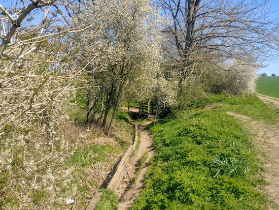
| The bridleway along Braughing Bourne |
Option 1: is to drop down to your left to a footbridge (location -
https://w3w.co/coder.surprises.elated) over Braughing Bourne and follow the brook through the woodland. This route, which is really charming but uneven underfoot (see image above), is marked in green on the maps above and below. It is probably muddy after rain.
Option 2: which is probably best if it’s muddy, is to continue heading ENE with the woodland and Braughing Bourne on your left and the fields on your right for 800m until you reach the point where the two paths converge (location -
https://w3w.co/kebab.skewing.lecturing).
 |
| Keep left with the hedgerow on the left and the field on the right |
At this point continue heading ENE for 200m with the hedgerow on the left and the field on your right ignoring the path across the crops to your right (see image above). Continue until you reach a junction in the tracks (location -
https://w3w.co/splint.polishing.mats).
 |
| Braughing footpath 6 continues to the left of the trees (point 3) |
3: Continue heading straight and NE, now on Braughing footpath 6, which at this point is also a metalled farm lane. Head uphill for 720m then follow the track as it bends left and heads N for 230m before reaching a left-hand bend with woodland ahead. Here you leave the lane and head NNE aiming to the left of the trees (location -
https://w3w.co/conquests.congratulations.stuff), see image above.
 |
| Braughing footpath 6 going into the woodland (point 4) |
4: Continue on Braughing footpath 6 with the woodland on your right for 140m until the path goes into the woodland (location -
https://w3w.co/replaces.airstrip.tribe), see image above.
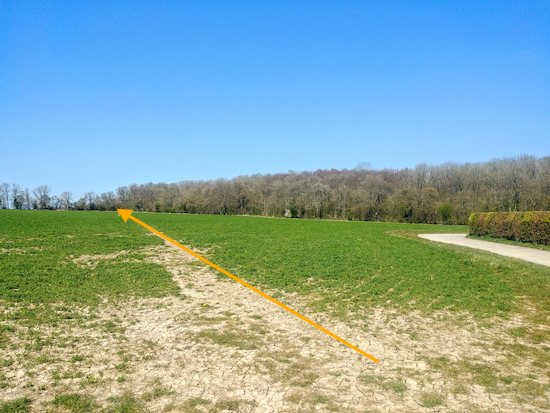 |
| Braughing bridleway 8 heading NW across the crops |
Continue through the woodland as the path heads ENE, then N for 400m to a junction (location -
https://w3w.co/rationed.views.punters). Here you turn right on Braughing bridleway 14 and head ENE for 350m until you reach a junction in the track (location -
https://w3w.co/finely.inhaled.corkscrew), with Braughing bridleway 8 on your left.
5: Turn left here and follow Braughing bridleway 8 NW across the field for 430m until you reach woodland (location -
https://w3w.co/probable.alike.unicorns).
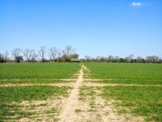 |
| Braughing restricted byway 31 heading towards Hormead footpath 21 |
6: When you reach the woodland take Braughing restricted byway 31 and, keeping the woodland on your right, and head N for 300m at which point the track you are on becomes Hormead footpath 21 and heads NNW for 120m before turning sharp left (location -
https://w3w.co/radiating.droplet.bets).
7: Follow Hormead footpath 21, which at this point is also the Hertfordshire Way, and head W for 1.2km ignoring a path to the right and left and continuing until you reach a T-junction in the track (location -
https://w3w.co/reforming.tolerable.inspected).
8: Turn left at the T-junction and head SW on Hormead footpath 16, which at this point is also the
Greenwich Meriden Trail, for 420m until you reach woodland (location -
https://w3w.co/teacher.educated.contemplate).
 |
| Walk through the woodland on Braughing restricted byway 24 (point 9) |
9: At this point your path becomes Braughing restricted byway 24 which you follow SSE for 360m until you reach the end of the woodland.
 |
| Follow the path through the woodland (point10) |
10: Here you turn left (see image above) and, with the hedgerow on your left and the field on your right head SE for 90m before the track bends to the right and you head SSE for 150m. Follow the path through the woodland (location -
https://w3w.co/ally.risky.surcharge), see image above.
11: Continue along this track as it bends to your left and heads E for 30m before it bends right to head SSE for 310m before reaching a junction with Braughing bridleway 12 (location -
https://w3w.co/promises.probing.hunk).
Turn right on Braughing bridleway 12 and head S for 170m to another junction (location -
https://w3w.co/calendars.dangerously.buckets).
 |
| Braughing bridleway 14 heading WSW (point 12) |
12: Turn right on Braughing bridleway 14 and head WSW then SW for 520m until you reach a path on your right (location -
https://w3w.co/resembles.senior.modules), see image below.
 |
| Braughing footpath 2B leaving Braughing bridleway 14 (point 13) |
13: Turn right on Braughing footpath 2B and head W then SSE for 540m until you reach a junction (location -
https://w3w.co/lavender.speeds.paintings).
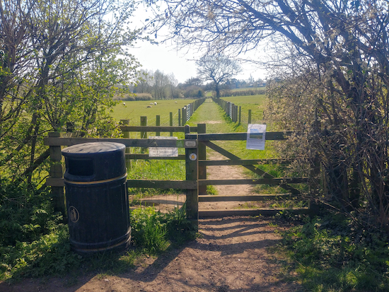 |
| Braughing footpath 25 leaving Braughing Boat 29 (point 14) |
14: Turn right on Braughing BOAT 29 (byway open to all traffic) and head W for 70m until you cross the River Quin. After crossing the river continue heading W for 60m looking out for a footpath on your left. (location -
https://w3w.co/waffle.mysteries.gives), see image above.
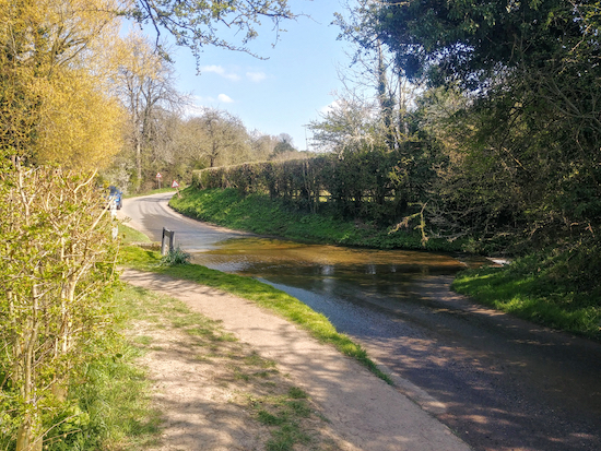 |
| The ford over the River Quin mentioned below |
Turn left on this path, Braughing footpath 25, and head S for 540m passing through two gates and eventually reaching a lane (location -
https://w3w.co/specifies.oxidation.depths).
Turn left on the lane, cross a footbridge over the River Quin, and follow the road E for 170m until it bends to the right and heads S back to the starting point.
* There is another pub in Braughing, The Golden Fleece (location - https://w3w.co/universal.ideals.overpaid) which is 420m W from the stating point, reached by heading W along Church End then Fleece Lane.
Interactive map


I'm about to walk this route for the third time, just love it, particularly the path along the Braughing Bourne. A great leisurely walk
ReplyDeleteHi Maggie, glad to hear it. We also enjoyed that walk and especially the section you mentioned.
DeleteDavid
Brilliant walk. Recommend to anyone to try it.
ReplyDeleteThanks for the feedback. Glad you enjoyed it.
DeleteBeautiful walk 🌷
ReplyDeleteThank you for the feedback. Glad you enjoyed it.
DeleteBrown Bear pub currently closed but Axe and Compasses good for lunch
ReplyDelete