5.4 miles (8.7 km) with 83m total ascent
 |
| Ayot St Peter bridleway 16 at point 9 in the walk |
This walk starts and ends in the Ayot Greenway car park just north of Ayot Green. It crosses open fields, reaches the halfway point at Ayot St Lawrence where you can take a break at The Brocket Arms, and then returns through wooded paths and bridleways as they weave their way back to the car park via the Ayot Greenway.
There is an option of refreshments close to the start and finish point at The Waggoners in Ayot Green and The Red Lion.
Directions
 |
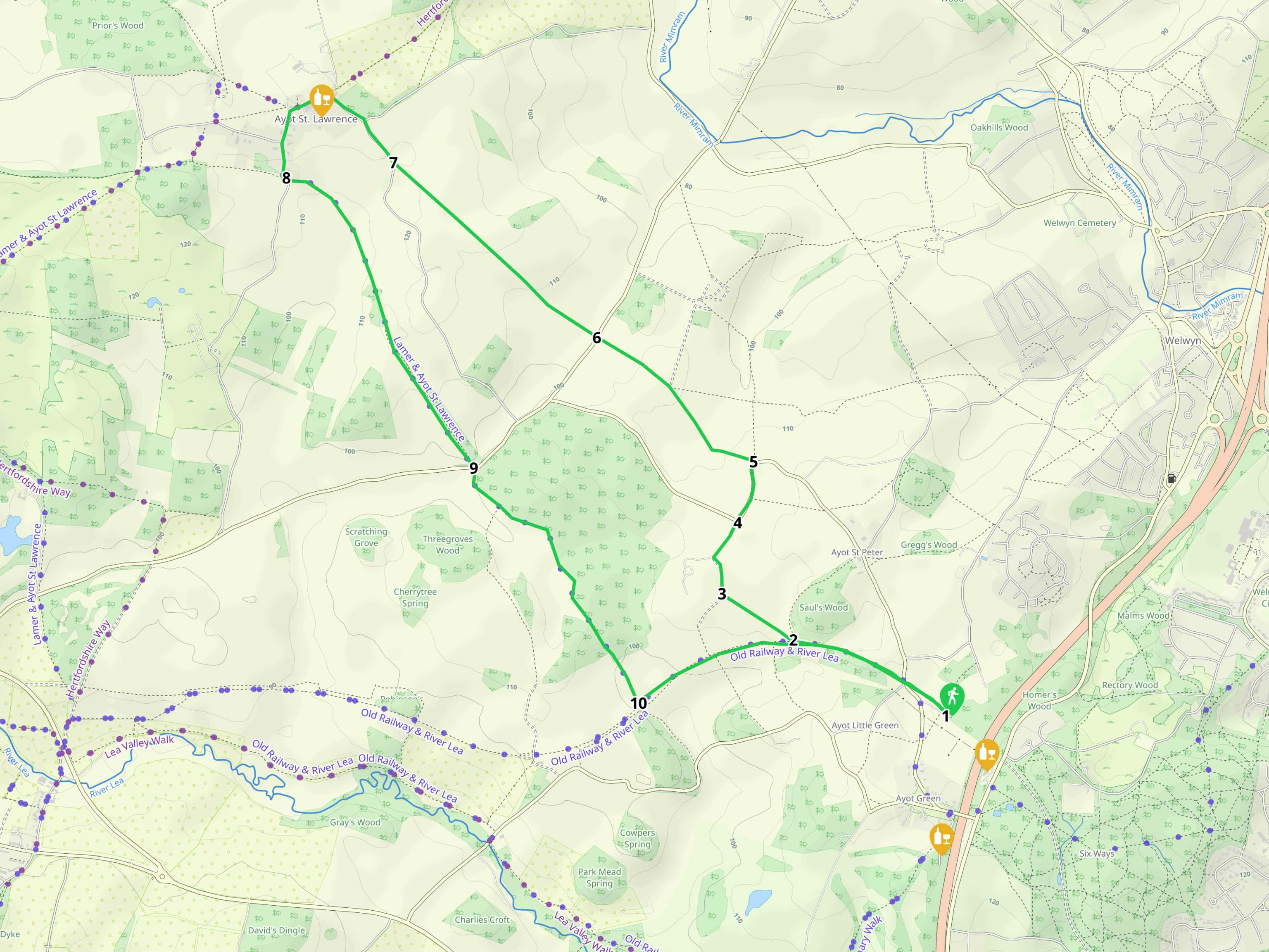
Map for Walk 40: Ayot Greenway North Loop
Click here or on the map above for a larger version
Map created on MapHub - copyright details here
There is an interactive map embedded at the end of these directions |
Those with GPS devices can download
GPX or
KML files for this walk. We've added
What3Words location references for those who use that system. If you print these walks you might want to use the green
PrintFriendly icon at the bottom of these directions to delete elements such as photographs.
1: From the car park (location -
https://w3w.co/saving.trade.loving), take the path on the right of the track you drove in on, see arrow on image below.
 |
| Take the path to the right of the track you drove in on |
Follow the course of the old railway branch line, the
Ayot Greenway, it heads W. You will go through a fence, see image below.
 |
| Go through the fence then continue heading NW |
Continue down some steps to reach Ayot St Peter Road (location -
ttps://w3w.co/broke.spins.shady). Cross the road then climb a set of stairs or walk up the ramp to reach the former track again (location -
https://w3w.co/crowned.ruby.bugs), see image below.
 |
| Climb the steps or walk up the ramp to reach the former track |
Continue along the Ayot Greenway for 710m heading NW passing Saul’s Wood on your right.
 |
| Immediately after the woodland take the path on the right |
2: Immediately after the woodland take the path on your right (location -
https://w3w.co/lance.dive.league). There are two paths here. Ignore the one that heads N along the edge of Saul’s Wood but, instead, take the one that heads NW diagonally across the field. This is Ayot St Peter footpath 18 which you follow for 350m across an arable field until you reach a track (location -
https://w3w.co/loans.search.codes), see image below.
 |
| Turn right then follow Ayot St Peter footpath 19 |
3: Turn right then follow Ayot St Peter footpath 19 for 350m as it bends NNW then NNE round Ayot Place and reaches a drive where it turns right (location -
https://w3w.co/crush.junior.storms), see image below.
 |
| Turn right then follow the main drive NE |
Turn right then follow the main drive NE for 160m until you reach a door to the right of large gates ahead (location -
https://w3w.co/tree.diary.retire).
 |
| Go through a door to the right of the gate |
4: Go through a door to the right of the gate and then another door on your left. Once through the second door turn right to emerge on Ayot St Peter Road.
 |
| Once through the second door turn right |
Continue straight heading NE along Ayot St Peter Road for 270m until you reach a bend and a bridleway on the left (location -
https://w3w.co/skills.rare.honest), see image below.
 |
| Follow Ayot St Peter bridleway 5 WNW |
5: Follow Ayot St Peter bridleway 5 as it heads WNW and then NW between the fields for 650m.
 |
| Follow Ayot St Peter bridleway 5 as it heads WNW between the fields |
Continue until you reach Codicote Road (location -
https://w3w.co/gravel.speaks.vines).
 |
| Cross the road then continue heading NW |
6: Cross the road then continue heading NW for 1.1km across the fields until you reach a gap in the hedge leading to Hill Farm Lane (location -
https://w3w.co/sector.label.adjust).
 |
| Cut through the hedgerow, turn right then follow Hill Farm Lane |
7: Turn right and follow this lane NW for 490m as it bends round to the left and into Ayot St Lawrence.
The Brocket Arms is on your left (location -
https://w3w.co/commented.racing.rank).
 |
| The Brocket Arms - Ayot St Lawrence |
 |
| The Brocket Arms - Ayot St Lawrence |
After leaving The Brocket Arms, turn left and head SW. You will pass Old St Lawrence Church on your right (location -
https://w3w.co/tender.poet.movies), see image below.
 |
| Old St Lawrence Church is a Grade II* listed building |
Old St Lawrence Church is a Grade II* listed building, and dates back to the 12th century. Continue following Bride Hall Lane as it bends S then passes
Shaw's Corner, the former home of George Bernard Shaw on the right (location -
https://w3w.co/farms.tilt.flute), see image below.
 |
| Shaw's Corner, the former home of George Bernard Shaw |
Continue until you reach a bend and a bridleway on your left (location -
https://w3w.co/clean.storm.copy).
 |
| Turn left on Wheathampstead bridleway 1 |
8: This is Wheathampstead bridleway 1, which later becomes Wheathampstead bridleway 11 then heads SE for 1.5km past
Stocking Springs (location -
https://w3w.co/puts.serves.loft), a Herts and Middlesex Wildlife Trust reserve (you can cut through Stocking Springs because a path through the reserve runs parallel to the one you are taking).
 |
| Our route follows the path on the right |
Our route follows the path on the right, but you can take the path on the left if you want to walk through Stocking Springs; they both end up in the same place. Continue until you reach Codicote Road (location -
https://w3w.co/agents.upgrading.manage).
 |
| Turn left on Codicote Road then take the bridleway on the right |
9: Turn left on Codicote Road then almost immediately take Ayot St Peter bridleway 16 on the right.
 |
| Take Ayot St Peter bridleway 16 |
Follow this bridleway for 1.3km along the side of Fish Wood and Warren Wood until you reach the Ayot Greenway (location -
https://w3w.co/plot.sits.descended). You will know you have reached the former railway line when you come to a bridge, see image below.
 |
| Climb the embankment just before the bridge to reach Ayot Greenway. |
10: Climb the embankment just before the bridge to reach Ayot Greenway.
 |
| Turn left on Ayot Greenway then follow it NE then SE |
Turn left on Ayot Greenway then follow it NE then SE for 1.4km until you reach Ayot St Peter Road (location -
https://w3w.co/lanes.finishing.savee), see images below.
 |
| Both options at the end of Ayot Greenway end up in the same place |
At the end of Ayot Greenway the path splits - don't worry, one is a ramp and the other leads to steps - they both end up on Ayot St Peter Road.
 |
| Cross Ayot St Peter Road then follow the path back to the car park |
Cross Ayot St Peter Road then climb the steps to follow the path you walked at the start of the walk back to the car park.
* If you want refreshments after the walk there is The Waggoners pub in Brickwall Close, Ayot Green, which is 620m S of the car park (location - https://w3w.co/pills.lasts.spices) and The Red Lion close by on Digswell Hill (location - https://w3w.co/nation.goes.fires).
Interactive map



I did this today, plus also the full Ayot Greenway to Wheathampstead and back. Exhausted now!
ReplyDeleteWell done combining two long walks. I wonder how many miles you clocked?
Delete